Showing 21775 results

Archival description
2023.2.2.12 · Deelreeks · 2007-2009
Part of Dr. Paul Sanborn fonds

A comparative study of grassland soils at 3 sites in northwestern BC and southern Yukon was published as:
Sanborn, P. 2010. Topographically controlled grassland soils in the Boreal Cordillera ecozone, northwestern Canada. Canadian Journal of Soil Science 90: 89-101. https://doi.org/10.4141/CJSS09048

This grew out of a field trip with Ministry of Forests range personnel to the Stikine and Tuya River valleys, near Telegraph Creek BC on August 27-28, 2007. (Two pedons were sampled in 2007, BC07-03 and BC07-04, but those results were not included in the paper.)

In August 2008, Dr. Paul Sanborn returned to the Stikine to sample pedon BC08-06, after field work in Yukon which collected the other two pedons used in the paper, from near Carmacks (Y08-39) and Kluane Lake (Y08-41). (An additional pedon from Kluane, Y08-43, was sampled and analyzed, but it was from a forested site and was not included in the paper.)

2023.2.2.13.1 · Bestanddeel · 2007-2008
Part of Dr. Paul Sanborn fonds

File contains the following data sets:

  • S925finl.xls [chemical analysis data, Ministry of Forests & Range, Analytical Chemistry Laboratory for pedons Y07-06 & Y07-07; also includes data for BC07-03 & BC07-04 (Boreal Cordillera grassland soils – see associated file note)]
  • S1007finl_revised2.xls [chemical analysis data, Ministry of Forests & Range, Analytical Chemistry Laboratory for pedons Y07-06 & Y07-07: oxalate & dithionite extractions, P retention; also includes P retention data for Nazko pedons BC07-07 & BC07-09]
  • CANTEST lab report 90206003.pdf [particle size analyses for Klutan Glacier pedons Y07-06 & Y07-07; also Tuya pedons BC07-03 & BC07-04 &]
Klutlan Glacier soils
2023.2.2.13 · Deelreeks · 2007-2010
Part of Dr. Paul Sanborn fonds

With the assistance of the Yukon Geological Survey, Dr. Paul Sanborn was able to visit the terminus of the Klutlan Glacier, a major outlet glacier which originates in the Alaska portion of the St. Elias Mountains. The stagnant terminus has a thick cover of debris, including a large component of White River tephra, providing enough soil material to support a boreal forest. Field work occurred on July 8, 2007, and results were published as:

Sanborn, P. 2010. Soil formation on supraglacial tephra deposits, Klutlan Glacier, Yukon Territory. Canadian Journal of Soil Science 90: 611-618. https://doi.org/10.4141/cjss10042

2023.2.2.12.3 · Stuk · Aug. 2007
Part of Dr. Paul Sanborn fonds

This document contains transcribed August 2007 field notes from 5 observation sites for Sanborn's comparative study of grassland soils in the Boreal Cordillera ecozone.

2023.2.2.12.5 · Bestanddeel · 2007-2009
Part of Dr. Paul Sanborn fonds

File contains the following data sets:

  • BC & Yukon 2008 soils data – compiled.xls [combined chemical & physical data for BC08-06, Y08-39, Y08-41, Y08-43]
  • S925finl.xls [chemical analysis data, Ministry of Forests & Range, Analytical Chemistry Laboratory for pedons BC07-03 & BC07-04; also includes data for Y07-06 & Y07-07 (Klutlan Glacier – see associated file note)]
  • S979finl(revised) – PS edits.xls [chemical analysis data, Ministry of Forests & Range, Analytical Chemistry Laboratory for BC08-06, Y08-39, Y08-41, Y08-43]
  • S994finl_revised.xls [chemical analysis data, Ministry of Forests & Range, Analytical Chemistry Laboratory for BC07-04 (CaCO3-equiv, total & inorganic C, pyrophosphate, oxalate & dithionite extractions) & selected horizons from BC07-07 & BC07-09 (Nazko basaltic soils))
  • CANTEST lab report 91010076.pdf [particle size analyses for BC08-06, Y08-39, Y08-41, Y08-43]
  • CANTEST lab report 90206003.pdf [particle size analyses for Tuya pedons BC07-03 & BC07-04 & Klutan Glacier pedons Y07-06 & Y07-07]
Llama in Kaleden, BC
2020.4.8.1.0020 · Stuk · May 1968
Part of G. Gary Runka fonds

Slide depicts a close up of a llama eating hay. The photograph was taken in Kaleden, BC. Original slide index description: "Llama, Kaleden."

Lion in Kaleden, BC
2020.4.8.1.0019 · Stuk · May 1968
Part of G. Gary Runka fonds

Slide depicts a close up of a lion lying on wood shavings in an enclosed area. The photograph was taken in Kaleden, BC. Original slide index description: "lion, Kaleden."

Eagles in Kaleden, BC
2020.4.8.1.0017 · Stuk · May 1968
Part of G. Gary Runka fonds

Slide depicts two eagles in an enclosure. The photograph was taken in Kaleden, BC. Original slide index description: "Eagles, Kaleden."

Camel in Kaleden, BC
2020.4.8.1.0016 · Stuk · May 1968
Part of G. Gary Runka fonds

Slide depicts a close up of a camel behind a fence. The photograph was taken in Kaleden, BC. Original slide index description: "Camel, Kaleden."

2020.4.8.1.0015 · Stuk · May 1968
Part of G. Gary Runka fonds

Slide depicts a camel and two llamas in an enclosed pasture. The photograph was taken in Kaleden, BC. Original slide index description: "Camel & Llamas in pasture, Kaleden."

Apple blossom in Kelowna
2020.4.8.1.0013 · Stuk · May 1968
Part of G. Gary Runka fonds

Slide depicts an apple tree blossoming in a backyard. The yard is surrounded by a wooden fence. Original slide index description: "Apple blossoms Kelowna."

Cherry blossoms
2020.4.8.1.0008 · Stuk · May 1968
Part of G. Gary Runka fonds

Slide depicts a close up of cherry blossoms on a branch. Original slide index description: "Cherry blossoms Kel."

Peach blossoms in Casa Loma
2020.4.8.1.0007 · Stuk · May 1968
Part of G. Gary Runka fonds

Slide depicts a close up of two peach trees blossoming in someone's yard. Original slide index description: "Close up of Peach Blossoms, Casa Loma."

2020.4.8.1.0006 · Stuk · May 1968
Part of G. Gary Runka fonds

Slide depicts a row of red and yellow tulips in front of a row of blossoming cherry trees. Original slide index description: "Tulips & Chery Blossoms Ok. Mission."

Mount Boucherie orchards
2020.4.8.1.0005 · Stuk · May 1968
Part of G. Gary Runka fonds

Slide depicts orchards surrounding Mount Boucherie. The Okanagan Lake and mountains can be seen in the background. Original slide index description: "Orchards & sunflowers from Mt. Boucherie."

Kelowna park entrance
2020.4.8.1.0004 · Stuk · May 1968
Part of G. Gary Runka fonds

Slide depicts the park entranceway to Kelowna on the East side of the Okanagan Lake Bridge. Original slide index description: "Park entrance to Kelowna."

Mission Flats
2020.4.8.1.0003 · Stuk · May 1968
Part of G. Gary Runka fonds

Slide depicts Mission Flats from South East Kelowna. Photograph taken from an empty field and depicts a developed field and a wooden house. Mountains and the Okanagan Lake can be seen in the background. Original slide index description: "Mission Flats from SE Kel."

Kelowna and Casa Loma
2020.4.8.1.0002 · Stuk · May 1968
Part of G. Gary Runka fonds

Slide depicts Kelowna and Casa Loma photographed during the day from across the Okanagan Lake in the Lakeview Heights area. Original slide index description: "Kel & Casa Loma from Lakeview Hts."

Apple blossom in Kelowna
2020.4.8.1.0001 · Stuk · May 1968
Part of G. Gary Runka fonds

Slide depicts a tree with apple blossoms in a backyard of a brown house. The yard is surrounded by a wooden fence. The neighbor's white house can be seen next door. Photographed in Kelowna, BC. Original slide description: "Apple Blossom bkyd. Kel."

"Prince George B.C."
2012.13.2.21.08.1 · Stuk · 26 Apr. 1967
Part of J. Kent Sedgwick fonds

This very large drawing shows CN leases and private property buildings on Island Cache in detail.

Zonder titel
2021.06.100 · Stuk · Apr. 1932
Part of Emil Bronlund Photograph Collection

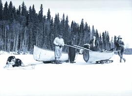
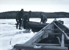
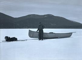
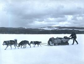
Photograph depicts Emil Bronlund, H. Witter, and rescue party alongside two canoes on sleds. A dog is harnessed to one of the sleds. The searching party consisted of E.H. Burden, C.H. Van Somer and Clarence Waldof from Prince George.

The following Prince George Citizen newspaper articles describe the incident:

“Searching Party Sets Out to Look for Emil Bronlund”
Prince George Citizen, April 21, 1932, p. 5

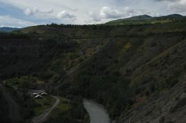
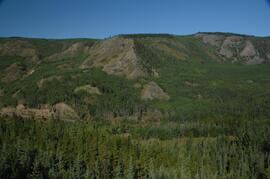
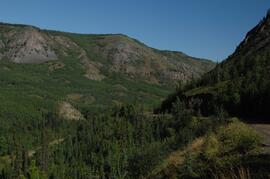
A searching party consisting of E.H. Burden, C.H. Van Somer and Clarence Waldof started out on Tuesday afternoon to look for Emil Bronlund, an engineer connected with the Consolidated Company who has been associated with a local syndicate in prospecting at the headwaters of the McLeod river. According to arrangements made Mr. Bronlund was to have arrived in Prince George last week, coming out by way of Fort McLeod, but in the absence of means of communication it was impossible to learn whether he started or whether he was detained in the vicinity of the area being prospected. Mr. Burden had the broadcasting station CKCD send out a message to J.E. McIntrye, in charge of the Hudson’s Bay post at McLeod, advising that Mr. Bronlund failed to arrive here, and suggesting a search if the missing man had passed the post.
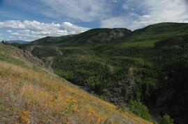
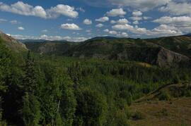
The search party from the end will travel by canoe from Summit Lake to Davie Lake, from which point it will mush over the trail to McLeod. It may be several days before word is received from it.

“Emil Bronlund was held up by bad weather”
Prince George Citizen, April 28, 1932, p. 1

Emil Bronlund, whose delay on the trip from the headwaters of McLeod River occasioned his friends in this city much uneasiness, reached Prince George on Saturday afternoon, accompanied by E.H. Burden and Henry Waldof, who started out some days ago to search for him. Messrs. Burden and Waldof had difficult going. Summit Lake is still frozen, and it was necessary for them on Thursday morning to drag their canoe over four miles of ice until they could strike open water in the Crooked River. Davie Lake was also covered with ice, and they were dragging their canoe over this when they came upon Bronlund and Ham Witter, making their way south in the same tedious way, dragging their boat over the ice. Bronlund explained he had been held up at Fort McLeod on his way out as it was impossible to travel. There was about a foot of water on the ice, and the trail being close to the water level it would have been foolhardy to attempt to come through.
It was at McLeod that Bronlund fell in with Witter. The latter had been trapping in the Nation River section but had been taken ill. He was delirious and unable to eat, and his boys decided to bring him out as far as the fort, and having the patient strapped to a toboggan. Witter improved rapidly at the fort and when Bronlund started south on Wednesday morning he decided to accompany him. They had been on the trail two days when they met Burden and Waldof.
The local syndicate, with which Bronlund is associated, has made a number of locations on the headwaters of McLeod River, and is preparing to do further prospecting to determine more fully the probable values contained in the gravels.