Item is an original copy of a 1989 "Program Review: The Agricultural Land Reserve Program" for the BC Ministry of Agriculture and Fisheries.
Item is a map depicting proposed land use between 1978 and 2012 in the City of Prince George. This map was drawn for the City of Prince George Community Plan; this particular version of the map was displayed in City of Prince George council chambers through 1979.
Item is the Proposed Land Use Map, 1978-2012, referred to in By-law No. 3138, the City of Prince George Official Community Plan. The original draft of this map was completed on October 24, 1977. This version of the map was amended in July 1982.
This 2-disc set contains the Prosperity Mine "Application for an Environmental Assessment Certificate pursuant to the British Columbia Environmental Assessment Act and Environmental Impact Statement for submission to the Federal Review Panel pursuant to the Canadian Environmental Assessment Act" of 2009. Contains 9 volumes of digital documents with accompanying appendixes, in PDF or Word document format.
Item is a photocopied journal reprint from Queen's Quarterly entitled "Public Management and Mismanagement of Natural Resources in Canada" from Vol. 73, No. 1, Spring 1966, pp. 86-99.
Item is an original copy of "Public Review Summary of Options for the Babine River Area" by the BC Ministry of Forests and BC Ministry of Environment, Lands and Parks from circa 1992. Includes an accompanying page of notes written by Joan Sawicki.
Item is an October 2000 public discussion paper published by the BC Ministry of Forests regarding the Queen Charlotte Timber Supply Area.
Item is an original copy of "Rails-to-Trails: Moving Forward - A Provincial Strategy for Converting Abandoned Railway Lines to Trails" published by the Outdoor Recreation Council of British Columbia.
Item is an original typescript entitled "Recreation Land Management Guidelines in Relation to Capability Ratings" by W.C. Yeomans, Project Director, British Columbia Recreation Sector.
Item is a typescript draft of a report written by M.J. Romaine entitled "Region No. 13 East Kootenay - Soil Capability for Forestry Report to B.C. Intersector Evaluation Committee".
Item is a "Report on the Victoria Symposium: The Appropriate Use of Land", held November 28-29, 1975 at the Provincial Museum in Victoria, British Columbia.
Item is an original unbound copy of "Report to the Legislature by the Select Standing Committee on Agriculture: Phase IV Research Report" by the Select Standing Committee on Agriculture of the BC Legislative Assembly.
Item is an original copy of "Resource Management Course for Certificate in Band Planning" prepared by G.G. Runka Land Sense Ltd. for the UBC School of Community and Regional Planning.
Item is an original copy of "Resource Planning in the Ministry of Forests: A Glossary of Past and Present Plans" by K. Ness, BC Ministry of Forests.
Item is an original copy of the 2010 "Review of the Agricultural Land Commission - Moving Forward: A Strategic Vision of the Agricultural Land Commission for Future Generations" submitted by Richard Bullock, Chair of the Provincial Agricultural Land Commission.
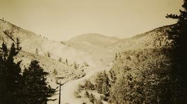
Photograph depicts the rock formations along the Cariboo Road north of Cache Creek. Wyness notes that the rock may be sandstone; there may be red iron oxide visible in the formation.
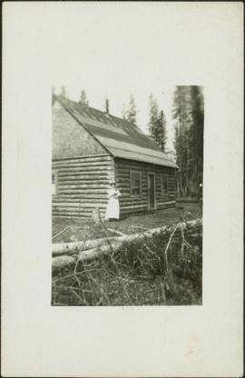
Photograph depicts Sarah Glassey, holding her fox terrier, and standing at corner of log house. Felled trees in foreground, forest trees in background. Photograph believed to have been taken on the 160 acres of land which Sarah purchased in the Kispiox Valley in 1911. She became the first single woman to pre-empt land in British Columbia. This house was built in a year with the help of a Gitxsan Elder.
Item is a copy of "Scheduling of Irrigation" by Brownlee, C.H. and J.C. Wilcox.
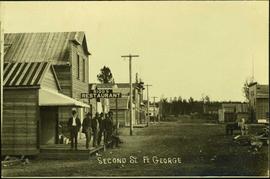
Photograph depicts a street scene along Second St. in Fort George. Wagons line the dirt road which is flanked by wooden buildings. A group of unidentified men stand on the boardwalk outside of Rigg's Restaurant. Handwritten annotation along bottom of photograph: "Second St. Ft. George".
Item is an original Canada Department of Agriculture Publication 1147 entitled "Seeding Forest Ranges in the Dry Belt of British Columbia".
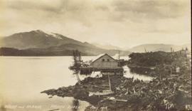
Side view photograph of a small harbor close by a shoreline littered in organic debris. A foggy mountain range is visible in the background. Annotation on recto reads: "Wharf and Harbor Prince Rupert. May 1908 JDA."
Item is a copy of "Silviculture - a site degradation consideration?".
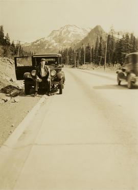
Photograph depicts a man, likely Gordon Wyness, sitting on the front of a 1930 Buick Series 40 car at the Snoqualmie Pass summit.
Item is a copy of "Soil Productivity and the Potential Food Supply of the United States: An Address before the Academy of Political Science at the Annual meeting on Food" by Bradfield, R.
Item is an original copy of "Soil Resources of the Smithers-Hazelton Area" by G.G. Runka at the Soil Survey Division, BC Department of Agriculture. Includes two accompanying maps.
Item is a photocopied version of "Soil Survey of the North Okanagan Valley" Interim Report by P.N. Sprout & C.C. Kelley for the BC Department of Agriculture.
Item is an original copy of "Spallumcheen: The Visual Environment" by W. C. Yeomans, Landscape Architect created for the B.C. Land Commission.
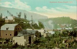
Hand coloured photo of various squatter's shacks and tents, with mountains in the background. Printed annotation on recto reads: "Squatters, Prince Rupert, B.C." Artist's stamp on lower right corner reads: "104,0033 J.V."
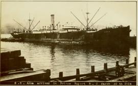
Photograph of ocean liner SS Arna docked in a harbour. Foreground shows two individuals on a dock in the lower right corner and a large pile of lumber in the lower left corner. Annotation on recto reads: "S.S. Arna arrived in Prince Rupert B.C March 30th 1914"
Item is an original copy of a report to the Minister of Agriculture and Food by Moura Quayle entitled "Stakes in the Ground: Provincial Interest in the Agricultural Land Commission Act".
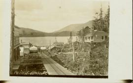
View of the road descending to the waterfront. Buildings and forested area are visible on either side of street. Annotation on recto reads: "Prince Rupert BC. '07."
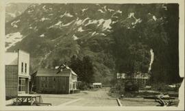
Photograph is a printed postcard depicting a wagon track between buildings situated on either side. There are mountains in the back ground. Possibly Stewart, BC.
The item is a reproduction of a survey map drafted June 1912. The reproduction was likely created in 1990. The area covered is Central Fort George, South of 5th Street, East of Alden Avenue, North of 12th Street and West of Fraser Street. Annotations state, "Plan 1085 Carney Addition."
The item is a reproduction of a survey map drafted in approximately 1911 and revised in May 1914. The reproduction was likely created in 1990. The annotation states, "Plan 1391" and is circled in red ink. The area covered is along the Nechako and Fraser Rivers and Northeast of First Avenue.
The item is a reproduction of a section of survey map drafted on 18 March 1915 and revised on 23 May 1916. The reproduction was likely created in 1990. The Plan Number is 1268 and highlights the area along the Nechako and Fraser Rivers. The map details subdivisions East of Carney Street, North of Twentieth Avenue and South of Ninth Avenue. Annotations in pencil state different map scale variations and "cemetery setback."
Item is an original Canada Department of Agriculture Publication 1179 entitled "Suitability for Irrigation of Water from Lakes and Streams in the Southern Interior of British Columbia".
Disc contents unknown (failed migration).
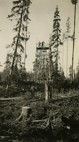
Photograph depicts two surveyors (Jack Lee, Gordon Wyness, or Philip Monckton) taking bearings from Pineview Station tower east of Prince George. Their surveying transit and telescope are visible in the image.
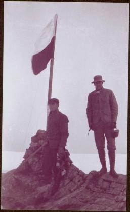
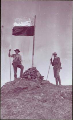
Photograph depicts two unidentified men standing to right of flag mounted in rock pile.
Image is one of 65 photos documenting a survey of the Canada-Alaska Boundary, Taku River area, May 23 to Oct. 15, 1906.
This particular photo is one of 13 found in original enclosure with the following handwritten annotation: "SOME OTHERS." See also items 2006.20.3.22 - 2006.20.3.34.
Photograph depicts two unidentified men standing to right of flag mounted in rock pile.
Image is one of 65 photos documenting a survey of the Canada-Alaska Boundary, Taku River area, May 23 to Oct. 15, 1906. This particular photo is one of 10 found in original enclosure with the following handwritten annotation: "From [Wahut?]-Azmuth and Koshu.” See also items 2006.20.3.47 - 2006.20.3.56.
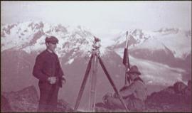
Photograph depicts two men on either side of camera on tripod, flag visible behind them. Mountain range and glacier in background.
Image is one of 65 photos documenting a survey of the Canada-Alaska Boundary, Taku River area, May 23 to Oct. 15, 1906. This particular photo is one of 9 found in original enclosure with the following handwritten annotation: "Pictures of different members of ‘our’ party.” See also items 2006.20.3.57 - 2006.20.3.65.
Audio cassette titled "Tape 1 - Dec. 10, 1993 - 9:30-1:45 - KBR" is believed to be an audio recording of a workshop for the East Kootenay CORE project.
Audio cassette titled "Tape 2 - Dec. 10, 1993 - 1:45-5:00" is believed to be an audio recording of a workshop for the East Kootenay CORE project.
![Proposed Land Use 1978-2012, Official Community Plan, City of Prince George [1979 Amendment]](/uploads/r/northern-bc-archives-special-collections-1/c/e/d/ced2c18ae074ee79ace57d0454f038b5e09774ff682567e053093476af37c166/2023.5.1.14_-_1979_-_1978-2012_Official_Community_Plan_City_of_Prince_George_JPG85_tb_142.jpg)
![Proposed Land Use 1978-2012, Official Community Plan, City of Prince George [1982 Amendment]](/uploads/r/northern-bc-archives-special-collections-1/6/6/9/669fc9dc3b840a6896f6a2a968a948283a3c5d972b6b48d718b427a57ebbe67f/2023.5.1.22_-_1982_-_Proposed_Land_Use_1982-2012_JPG85_tb_142.jpg)
