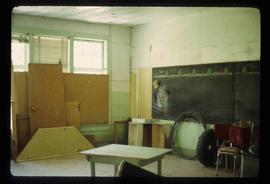
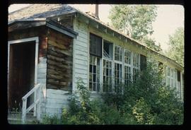
Image depicts the old school building in Lamming Mills, B.C.
Image depicts a snowman drawn on the chalkboard of what appears to be an unused school, possibly in Lamming Mills, B.C. The slide is labelled "note board school."
Image depicts a row of houses and the side of a train in Crescent Spur, B.C.
Image depicts what appears to be a small mill in the community of Crescent Spur, B.C.
Image depicts several buildings in the community of Loos, B.C.
Image depicts the railway running near Crescent Spur in the Rocky Mountain Trench.
Image depicts the community of Crescent Spur, B.C.
Image depicts a beehive burner in the community of Crescent Spur, B.C.
Image depicts a church school in the community of Crescent Spur, B.C.
Image depicts a Yellowhead Realty sign in Lamming Mills, B.C. It reads: "For Sale, entire community, 50 buildings, 60 acres."
Image depicts a heavily forested area located in the Rocky Mountain Trench, possibly near Dome Creek or Lamming Mills, B.C.
Image depicts the community of Crescent Spur, B.C.
Image depicts a heavily forested area located in the Rocky Mountain Trench, possibly near Dome Creek or Lamming Mills, B.C.
Image depicts the McBride District Centennial Library.
Image depicts McBride, B.C.
Image depicts an abandoned building on the corner of a street in McBride, B.C. The faded letters on the side read: "McBride Trading Co. Mens Wear, Drugs, Equipment."
Image depicts the All Saints Anglican Church in McBride, B.C. The slide labels it as having "moved to PG."
Image depicts a house somewhere in McBride, B.C.
Image depicts the Elks Hall in McBride, B.C.
Image depicts a machine shop somewhere in McBride, B.C. The sign above the door reads "McBride Air Cooled Engine Services Ltd."
Image depicts an old house somewhere in McBride, B.C.
Image depicts a street in McBride, B.C.
Image depicts an abandoned building on the corner of a street in McBride, B.C.
Image depicts a street in McBride, B.C. One of the store signs reads "Allied Hardware."
Image depicts the rear-end of the CN Station in McBride, B.C.
Image depicts the CN Station in McBride, B.C.
Image depicts Mt. Fitzwilliam.
Image depicts an old road through the trees near Yellowhead Pass. The slide labels it as the origin of the Yellowhead highway.
Image depicts the Valemount CN Station.
Image depicts a mountain at an uncertain location.
Image depicts a forest service cabin somewhere near Tête Jaune Cache, B.C.
Image depicts a collapsing shack somewhere near Tête Jaune Cache, B.C.
Image depicts a vehicle on a gravel road somewhere near Tête Jaune Cache, B.C.
Image depicts Yellowhead Lake, located near the Yellowhead Pass.
Image depicts numerous lily pads on the surface of Portal Lake, located near the Yellowhead Pass on the British Columbia-Alberta border, west of Jasper, A.B.
Image depicts a view of the Rocky Mountain Trench.
Image depicts a view of McBride in the Rocky Mountain Trench.
Image depicts a view of an area somewhere near McBride in the Rocky Mountain Trench.
Image depicts the ranch house of the Ranch of the Vikings, originally owned and operated by Bjorger Pettersen, a member of the Canadian Ski Hall of Fame, from 1970 until 1985. It is located somewhere west of McBride, B.C.
Image depicts a view of the Rocky Mountain Trench somewhere near McBride, B.C.
Image depicts a river somewhere in Mt. Robson Provincial Park, with a bridge running over it. The slide itself is labelled "Robson station."
Image depicts the peak of Mt. Robson.
Image depicts a view of Valemount, with numerous mountains in the background.
Image depicts a distant view of what appears to be a body of water, with numerous mountains in the background. The slide is labelled "Valemount reservoir."
Image depicts a view of Valemount with numerous mountains in the background.