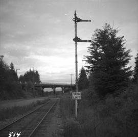
Photograph depicts yard signals of the MacMillan Bloedel & Powell River Logging Railway, primarily protecting the Comox Logging & Railway Company crossing. The Esquimalt and Nanaimo Railway is about 300 yards to the north. Crossing is near Ladysmith. It is most unusual to find signal in B.C. at this point.
Photograph annotation states that image depicts a CPR warehouse located about 1/4 mile east of the Revelstoke depot, on the north side of the track. The view is looking east. Additional information provided by railway historian Tom W. Parkin: This building is the CPR icehouse at Revelstoke after a partial tear-down. The structure was built after 1929, when a similar facility near the locomotive shops was removed between 1920-29, possibly to make room for a larger turntable. The location is on the northwest edge of the CPR yards. Icehouses once made and stored blocks of ice for refrigeration of passenger coaches and (when crushed) for cooling fresh produce in "reefer cars" en route to market.
Plan depicts Granville Island industrial sites in False Creek, Vancouver. Shows revised trackage from 1955 annotated in colour by Davies.
Photograph depicts the CPR line at Revelstoke. The present terminus is about 1 mile south of the mainline depot of the former Arrowhead branch line (27.5 miles long) which became submerged when Arrow Lake was raised 70 ft. in 1968-1969.
Photograph depicts a 4-wheeled cart located on Tsalalh Nation territory at the head of Seton Lake.
Photograph depicts Beaver Trucking located on Kamloops Indian Reserve No. 1 on Tk'emlups te Secwepemc territory, Kamloops, BC. It had been a company since 1990 and received 2 or 3 boxcars weekly loaded with items from Toronto that were then delivered around town. Davies later noted that the business was destroyed by arson in 1997.
Photograph depicts a car crossing the Lillooet Suspension Bridge (also known as the Lillooet Old Bridge) over the Fraser River.