Mostrar 5005 resultados

Archival description
3026 resultados com objetos digitais Mostrar resultados com objetos digitais
Honey Sales
2012.13.1.91.57 · Item · 1979
Parte de J. Kent Sedgwick fonds

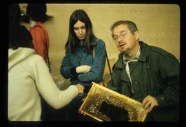
Image depicts several unidentified individuals standing in front of a store selling honey.

Bee Colony
2012.13.1.91.56 · Item · 1979
Parte de J. Kent Sedgwick fonds

Image depicts a man in a yellow cap who appears to be blowing smoke into a bee colony at a bee farm. It appears to be an educational demonstration.

Honeycombs?
2012.13.1.91.55 · Item · 1979
Parte de J. Kent Sedgwick fonds

Image depicts an unidentified man holding what appears to be a broken screen of honeycombs. The group is likely at an educational event.

Man in a Yellow Hat - Wood Pieces?
2012.13.1.91.54 · Item · 1979
Parte de J. Kent Sedgwick fonds

Image depicts an unidentified man in a yellow hat who appears to be speaking to large group of people and showing them small pieces of wood. It is possibly an educational event.

People and a Bridge
2012.13.1.91.50 · Item · 1979
Parte de J. Kent Sedgwick fonds

Image depicts several unidentified individuals and a bridge behind them; it is possibly crossing the Peace River.

People on a Bridge
2012.13.1.91.49 · Item · 1979
Parte de J. Kent Sedgwick fonds

Image depicts several unidentified individuals standing on a bridge; it possibly crosses the peace River.

Moberly Lake
2012.13.1.91.46 · Item · 1979
Parte de J. Kent Sedgwick fonds

Image depicts an obstructed view of Moberly Lake, located north of Chetwynd and south of Hudson's Hope, B.C.

W.A.C. Bennett Dam?
2012.13.1.91.44 · Item · 1979
Parte de J. Kent Sedgwick fonds

Image depicts several unidentified individuals lying on a hill outside what is most likely the W.A.C. Bennett Dam in Hudson's Hope, B.C.

Chetwynd - Motor Hotel and Esso
2012.13.1.91.40 · Item · 1979
Parte de J. Kent Sedgwick fonds

Image depicts several businesses in a small section of Chetwynd, B.C. There is a motor hotel and a half-visible sign for an Esso gas station.

Railway Tracks and Rocks
2012.13.1.91.39 · Item · 1979
Parte de J. Kent Sedgwick fonds

Image depicts a group of individuals who appear to be searching through the rocks near a railway track. It is possibly part of an educational trip.

Examining a Rock
2012.13.1.91.38 · Item · 1979
Parte de J. Kent Sedgwick fonds

Image depicts a group of individuals who appear to be examining a rock. It is possibly part of an educational trip.

Large Group Near a Bridge
2012.13.1.91.34 · Item · 1979
Parte de J. Kent Sedgwick fonds

Image depicts a large group of people sitting and eating near a bridge at an uncertain location, though possibly near Hudson's Hope, B.C.

Crowded Cafeteria
2012.13.1.91.33 · Item · 1979
Parte de J. Kent Sedgwick fonds

Image depicts a crowded cafeteria, most likely somewhere in Hudson's Hope, B.C. The slide is labelled "Camp at H.H."

Chetwynd
2012.13.1.91.32 · Item · Nov. 1978
Parte de J. Kent Sedgwick fonds

Image depicts a view of Chetwynd, possibly from Highway 97.

Pine Pass
2012.13.1.91.31 · Item · Nov. 1978
Parte de J. Kent Sedgwick fonds

Image depicts an unidentified individual standing near a drop-off in the Pine Pass between Alberta and British Columbia. The sign behind the individual reads: "Pine Pass - 2,868 FT. Here the great barrier of the Rock Mountains is breached by the lowest highway pass. Once the remote route of the trapper, it now links the commerce of the north and markets of the south. The John Hart Highway was completed in 1952 and followed by the P.G.E. in 1958. Gas and oil lines also take advantage of this convenient natural feature."

A Bridge
2012.13.1.91.30 · Item · Oct. 1978
Parte de J. Kent Sedgwick fonds

Image depicts a truck on a bridge, possibly crossing over the Peace River.

Sediment Layers
2012.13.1.91.27 · Item · Oct. 1978
Parte de J. Kent Sedgwick fonds

Image depicts a wall of rock with visible sediment layers at an uncertain location in the Peace River Region, possibly near Hudson's Hope.

Sediment Layers
2012.13.1.91.24 · Item · Oct. 1978
Parte de J. Kent Sedgwick fonds

Image depicts an unidentified individual standing in front of a rock face with visible sediment layers. Located somewhere in the Peace River Region, possibly near Hudson's Hope.

Peace River
2012.13.1.91.23 · Item · Oct. 1978
Parte de J. Kent Sedgwick fonds

Image depicts the Peace River, possibly near Hudson's Hope, B.C.

Hudson's Hope - Motel?
2012.13.1.91.15 · Item · Oct. 1978
Parte de J. Kent Sedgwick fonds

Image depicts what appears to be a motel in Hudson's Hope, B.C. The slide is labelled "camp HH."

Peace River
2012.13.1.91.13 · Item · Oct. 1978
Parte de J. Kent Sedgwick fonds

Image depicts the Peace River, possibly near Clayhurst or Hudson's Hope, B.C.

Peace River
2012.13.1.91.12 · Item · Oct. 1978
Parte de J. Kent Sedgwick fonds

Image depicts the Peace River, possibly near Clayhurst or Hudson's Hope, B.C.

Peace River Region - A Street of Shops
2012.13.1.91.08 · Item · Oct. 1978
Parte de J. Kent Sedgwick fonds

Image depicts a street of shops at an uncertain location somewhere in the Peace River Regional District. A pink and blue building, possibly a theatre, is labelled "Lux."

A Highway
2012.13.1.91.07 · Item · Oct. 1978
Parte de J. Kent Sedgwick fonds

Image depicts a stretch of highway, possibly Highway 29 or 97.

Peace River?
2012.13.1.91.06 · Item · Oct. 1978
Parte de J. Kent Sedgwick fonds

Image depicts what is possibly the Peace River running parallel to a road, possibly Highway 29.

Fort St. John
2012.13.1.91.03 · Item · Sep. 1974
Parte de J. Kent Sedgwick fonds

Image depicts an area of forests and fields somewhere near Fort St. John, B.C.