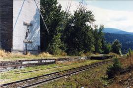
Showing 4417 results

Archival description
3218 results with digital objects Show results with digital objects
CPR Wynndel
2013.6.36.1.129.01 · Item · Sept. 2000
Part of David Davies Railway Collection

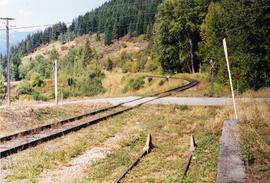
Photograph depicts a grain elevator that had a 7 car spur to service it. Davies doubted if grain traffic ever moved by rail near Wynndel. Two flat cars appeared to have used the platform to overload machinery and vehicles.

Giscome - Eaglet Lake
2012.13.1.87.090 · Item · [between 1980 and 2000]
Part of J. Kent Sedgwick fonds

Image depicts mill site and dock in Giscome, B.C. with Eaglet Lake in the background covered in ice. There is a large crowd of people gathered near the dock. Map coordinates 54°04'34.9"N 122°21'50.0"W

Street in Giscome - After
2012.13.1.87.094 · Item · [between 1980 and 2000]
Part of J. Kent Sedgwick fonds

Image depicts a street in Giscome. The store was previously located on the left. The church is in the background. Map coordinates 54°04'18.5"N 122°21'57.7"W

Prince George Sawmill
2012.13.1.3.158 · Item · Nov. 2000
Part of J. Kent Sedgwick fonds

Image depicts Prince George Sawmill taken from across the Nechako River looking southwest. Map coordinates 53°56'00.0"N 122°44'29.7"W

James Renwick's house
2012.13.3.1.06 · File · 1978-2000
Part of J. Kent Sedgwick fonds

File consists of a typed document and a clipped article relating to the house of James Renwick. The house was one of the oldest residences in Prince George and was built for James Renwick, a local MLA and one of the original proprietors of the Prince George Citizen newspaper. Includes: "RE: Proposed Subdivision" typed document from the City of Prince George (22 Sept. 2000) and a clipped article from the Prince George Citizen newspaper "A house worth saving" which discusses the Renwick house, later owned by Bruno and Dorothea Meyer (18 May 1978).

Mackenzie Town
2012.13.1.070 · Subseries · [between 1973 and 2000]
Part of J. Kent Sedgwick fonds

File contains slides depicting places in and around Mackenzie Town.

1690 Dogwood Street
2012.13.1.24.32 · Item · 2000
Part of J. Kent Sedgwick fonds

Image depicts 1690 Dogwood Street, on the corner of 17th Ave and Dogwood St. in Prince George, B.C. Also depicts a portion of 1670 Dogwood Street at left.

CPR Wynndel
2013.6.36.1.129.04 · Item · Sept. 2000
Part of David Davies Railway Collection

Photograph taken looking north, with a spur in the foreground. It was used by ore mixed freight daily. It was believed that at the bottom of the grade was a junction with a GNR branch that ran from the US border south of Creston to Kootenay Lake (built in 1904, then was hardly used, finally ceased in 1910).

Prince George Sawmill
2012.13.1.3.159 · Item · Nov. 2000
Part of J. Kent Sedgwick fonds

Image depicts Prince George Sawmill taken from across the Nechako River looking southwest. Map coordinates 53°56'00.0"N 122°44'29.7"W

Millar Addition
2012.13.1.024 · Subseries · [between 1979 and 2000]
Part of J. Kent Sedgwick fonds

File contains slides depicting the Millar Addition suburb in Prince George, B.C.

Veteran House
2012.13.1.24.36 · Item · 2000
Part of J. Kent Sedgwick fonds

Image depicts a property given to the Veterans of the Second World War, located on the corner of 15th Avenue and Elm Street in Prince George, B.C.

2012.13.1.135.01.05 · Item · [between 1980 and 2000]
Part of J. Kent Sedgwick fonds

Photograph depicts Rosel's restaurant at 1624 7th Avenue. Rosel's restaurant was owned and operated by Wilfred and Rosel Vogt from 1981 to 1997. The building was built in 1916 and was originally owned by Dr. Carl Ewart and later owned by Hubert King of Wilson, King and Company, the oldest law firm in Prince George, after 1946. The building is now a designated heritage building.

2012.13.1.135.01.11 · Item · [between 1980 and 2000]
Part of J. Kent Sedgwick fonds

Photograph depicts a residential building at 1612 12th Avenue, the building was used as "Prince Realty". Annotation on verso: "1612 - 12th Ave., NW corner of Vancouver."