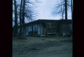
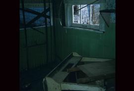
Image depicts the interior of a house that appears to be abandoned and in disrepair in Island Cache.
Image depicts a view of Francois Lake.
Image depicts a street in Barkerville, near Wells, B.C.
Image depicts an old log building in Fort St. James; the sign on it reads "Clerk's Living Quarters, Later Used as Fort St. James First School."
Image depicts Stuart Lake in Fort St. James, B.C.
Image depicts an unrestored, collapsing log-house in Barkerville, B.C.
Image depicts several unknown individuals in the China Town of Barkerville, B.C.
Image depicts a number of small houses at Island Cache.
Image depicts a stand of trees and a shed at Island Cache.
Image depicts what is likely an outhouse at Island Cache.
Image depicts a clearing at Island Cache.
Image depicts a grocery store at Island Cache.
Image depicts a house in Island Cache. There are several cars parked outside it.
Image depicts a boarded up building in Island Cache.
Image depicts two children standing near an old car in Island Cache.
Image depicts a number of sheds in Island Cache.
Image depicts the Fraser River from Highway 97 near Quesnel, B.C.
Image depicts a couple of salmon in the Stellako River.
Image depicts a view of Francois Lake.
Image depicts what is possibly an intrusive volcanic landform somewhere near Miworth, B.C.
Image depicts Mt. Robson.
Image depicts an atmometer. According to the slide, it is being used for measuring the rate of water evaporation "from carborundum stone." The location is uncertain.
Image depicts a snow gauge at an uncertain location.
Image depicts an unidentified individual standing next to a marker and a stake at an uncertain location.
Image depicts objects, including a flag pole, that the slide labels as "survey equipment." The slide also places it as a "Peyto icefall," on the Peyto Galcier in the Banff National Park in Alberta, B.C.
Image depicts a scenic view of a mountain and forest at an uncertain location.
Image depicts a hand-held ice drill.
Image depicts an unidentified individual drilling into the ice.
Image depicts a road located somewhere near Birken, B.C.
Image depicts the Place Glacier.
Image depicts an unknown individual at the Place Glacier.
Image depicts the mostly frozen Place Creek Falls.
Image depicts two unknown individuals at the Place Glacier.
This very large drawing shows CN leases and private property buildings on Island Cache in detail.
Lockwood Survey Corporation Ltd.Image depicts some power lines and a forest somewhere near Birken, B.C.
Image depicts the Place Glacier. There are two unknown individuals present.
Image depicts two unknown individuals at the Woolsey Glacier.
Image depicts an unidentified individual setting up some sort of pole in the snow for a process the slide labels as "snow sounding." The location is uncertain.
Image depicts a snow-covered cabin and a mountain in the distance. It is located somewhere near Birken, B.C.
Image depicts a mountain in the distance. It is located somewhere near Birken, B.C.
Image depicts a road located somewhere near Birken, B.C.
Image depicts the Place Glacier.
Image depicts the Place Glacier. There are two unknown individuals present.
Image depicts two unknown individuals at the Woolsey Glacier.
Image depicts a helicopter flying over the Woolsey Glacier.
Image depicts a marker for aerial photography at an uncertain location. The slide labels it as "Elizabeth Station."
Image depicts Pineview on Buckhorn Lake Road, Prince George, B.C.