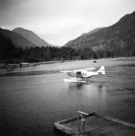
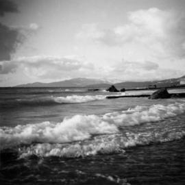
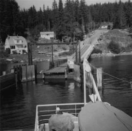
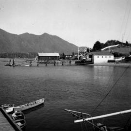
Photograph depicts Tofino on Vancouver Island. View taken from wharf with a lifeboat on slip.
Photograph depicts a house fire possibly on 1000 Beach Block and Thurlow St. , caused by a wrecking gang.
Photograph depicts a house fire on 1000 Beach Block and Thurlow St. on December 18, 1964. A wrecking gang accidently set fire to the house and it took one hour to get the fire under control.
Photograph depicts a float plane landing at Gold River on west Vancouver Island.
Photograph depicts a house fire possibly on 1000 Beach Block and Thurlow St. , caused by a wrecking gang.
Photograph depicts homes on 1000 Beach Ave., looking northeast.
Photograph depicts homes on 1000 Beach Ave., looking northeast. House #1053 on the left has been demolished at this point and then set on fire one night by kids.
Photograph depicts the 1000 Beach Ave. block with dogwood rose tree in bloom at the left of the photo.
Photograph depicts homes on 1000 Beach Ave. in Vancouver, B.C.
Photograph depicts house at #1053 Beach Ave. in Vancouver, B.C. Dan Davies was a resident at one time.
Photograph depicts the ongoing wrecking of house #1053 on Beach Ave.
Photograph depicts the homes on 1000 Beach Ave. in Vancouver, B.C.
Photograph depicts Beach Ave. in Vancouver, with the photo taken near the swimming pool and looking west. Photo was taken after a storm.
Photograph depicts home at #1053 Beach Ave., which is now fully demolished.
Photograph depicts an empty site at 1000 Beach Ave. in Vancouver, B.C.
Photograph depicts the inside of the suite at 925 Cadero St. in the west end of Vancouver, B.C.
Photograph depicts a dogwood tree in front of the garden at 1057 Beach Ave. in Vancouver. The photo is taken looking northeast.
Photograph depicts the dogwood tree in winter at the former site of 1057 Beach Ave. in Vancouver. The view is looking east.
Photograph depicts the city hall at New Westminster on Victoria Day. The anvil battery is about to fire a 21 gun salute.
Photograph depicts the city hall at New Westminster on Victoria Day. The anvil battery firing round #3 of 21 gun salute.
Photograph depicts a field being cleared near Miracle Beach, 20 minutes south of Campbell River, on Vancouver Island.
Photograph depicts fields recently cleared from virgin bush on Miracle Breach on Vancouver Island.
Photograph depicts telephone fittings on Vancouver Island.
Photograph depicts land clearance between Monashee Pass and Lumby, B.C.
Photograph depicts telephone fittings on Vancouver Island.
Photograph depicts coal miners near Buckley Bay. The afternoon shift (3 p.m.) is going down the Tsable drift mine, which is the only working coal pit on Vancouver Island in 1964 and has a total of 70 employees. It is run by the Comox Colliery Co. and has a daily production of 200-300 tons.
Photograph depicts the Tsable coal pit on Vancouver Island as the first coal of the afternoon shift being hauled up.
Photograph depicts a small coal tram at Tsable coal pit near Fanny Bay on Vancouver Island.
Photograph depicts Granite Falls near the Wigwam Inn, Indian Arm, Vancouver, B.C.
Photograph depicts a view of Indian Arm, looking south from Granite Falls.
Photograph depicts the entrance to False Creek in Vancouver, B.C. The wooden navigation marker has since been removed. The photo is taken from 1053 Beach Ave.
Photograph depicts Granite Falls and wharf at Indian Arm, looking west from the top of the falls.
Photograph depicts a the shoreline of Vancouver Harbour, looking east from the property line of the Burrard Grain Elevator, 375 Low Level Rd, North Vancouver.
Photograph depicts the ferry from Campbell River approaching the Quathiaski Cove slip on Quadra Island.
Photograph depicts the upper end of Coal Harbour, on the south shore looking southwest and taken from the dock of the Vancouver Shipyards Ltd.
Photograph depicts a general view of the upper and south shore section of Coal Harbour in Vancouver, B.C.
Photograph depicts a view looking northeast towards Coal Harbour from Alberni St. (Chilco-Gilford block) with West Georgia St. in the middle distance.
Photograph depicts a general view of the last 300 yards of the upper neck of Coal Harbour in Vancouver, B.C. The view is looking west and taken from the south side.
Photograph depicts the Vancouver Shipyards Ltd. on 555 Denman St. in Vancouver, B.C., looking south from Coal Harbour waters.
Photograph depicts a general view of Coal Harbour in Vancouver, looking southeast and taken from Royal Vancouver Yacht Club premises. Photo shows the Bayshore Hotel on the extreme left.
Photograph depicts a general view of Coal Harbour in Vancouver, looking southeast and south with Marine Building (downtown) on extreme left and Stanley Park (unseen) at extreme right.
Photograph depicts the west end of Coal Harbour looking south to West Georgia St. and Chilco-Gilford block beyond. The old pilings exposed at low tide.
Photograph depicts the construction of a new deep sea wharf on the site of an old Hastings mill in Vancouver, B.C. The forepart is to be dirt filled. The view is looking northeast.
Photograph depicts the site of a new deep water ship wharf with Centennial Pier in the background, looking east. Left of the wall is the sea and the right side will be dirt filled.
Photograph depicts a steam grab working on the new dock to the west of Centennial Pier, on the site of a former Hastings mill in Vancouver, B.C. The view is looking north and the foreground depicts tidal water.
Photograph depicts the construction of a new deep sea wharf on the site of an old Hastings mill, at the foot of Dunlevey St., in Vancouver, B.C. The forepart is to be dirt filled. The view is looking northeast.
Photograph depicts the site of a new deep water ship wharf. The left of the wall is sea and the right will be filled in with dirt. The view is looking east and shows the Centennial Pier in the background.