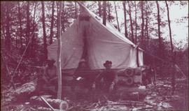
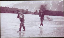
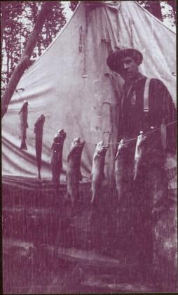
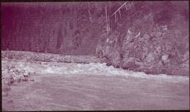
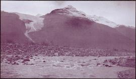
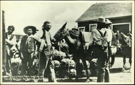
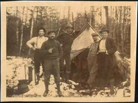
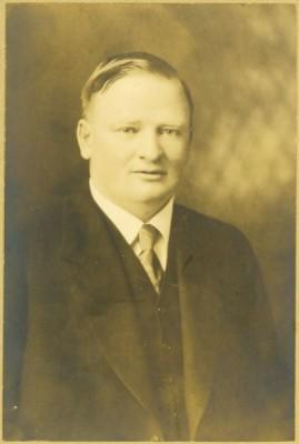
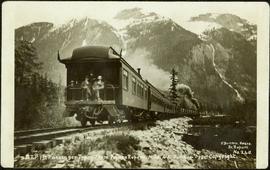
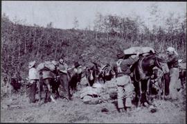
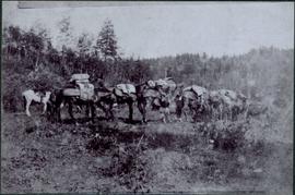
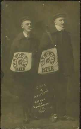
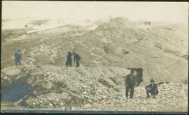
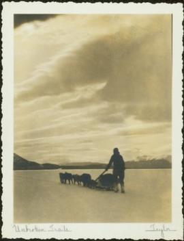
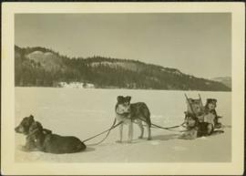
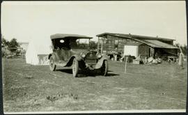
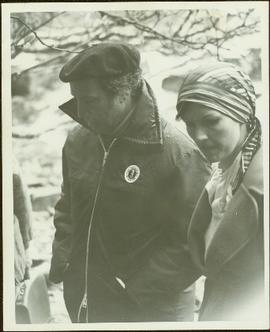
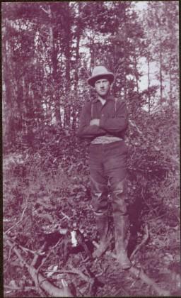
Image is one of 65 photos documenting a survey of the Canada-Alaska Boundary, Taku River area, May 23 to Oct. 15, 1906. This particular photo is one of 9 found in original enclosure with the following handwritten annotation: "Pictures of different members of ‘our’ party.” See also items 2006.20.3.57 - 2006.20.3.65.
Photograph depicts three men sitting in front of tent structure with log base, trees in background. Believed to be main campsite area (see item 2006.20.3.59).
Image is one of 65 photos documenting a survey of the Canada-Alaska Boundary, Taku River area, May 23 to Oct. 15, 1906. This particular photo is one of 9 found in original enclosure with the following handwritten annotation: "Pictures of different members of ‘our’ party.” See also items 2006.20.3.57 - 2006.20.3.65.
Photograph depicts two men walking with rope stretched between them close to shore of river, canoe floating behind them. Opposite shore crosses midground, mountains stand in background. Handwritten annotation visible on negative: "Gilroy & [Nellis?] - Kopoka River".
Image is one of 65 photos documenting a survey of the Canada-Alaska Boundary, Taku River area, May 23 to Oct. 15, 1906. This particular photo is one of 9 found in original enclosure with the following handwritten annotation: "Pictures of different members of ‘our’ party.” See also items 2006.20.3.57 - 2006.20.3.65.
Photograph depicts unknown man standing behind fish hung on a line. Tent and trees in background.
Image is one of 65 photos documenting a survey of the Canada-Alaska Boundary, Taku River area, May 23 to Oct. 15, 1906. This particular photo is one of 9 found in original enclosure with the following handwritten annotation: "Pictures of different members of ‘our’ party.” See also items 2006.20.3.57 - 2006.20.3.64.
Photograph depicts tent among trees, hills visible in background.
Image is one of 65 photos documenting a survey of the Canada-Alaska Boundary, Taku River area, May 23 to Oct. 15, 1906.
This particular photo is one of 13 found in original enclosure with the following handwritten annotation: "Kopoka River - river scenes Aug 29 to Oct. 9 [19]06". See also items 2006.20.3.1 - 2006.20.3.13.
Photograph depicts white rapids, shore visible on either side of river. Handwritten annotation on negative: "Rough water at [Kopoka?] River".
Image is one of 65 photos documenting a survey of the Canada-Alaska Boundary, Taku River area, May 23 to Oct. 15, 1906.
This particular photo is one of 13 found in original enclosure with the following handwritten annotation: "Kopoka River - river scenes Aug 29 to Oct. 9 [19]06". See also items 2006.20.3.1 - 2006.20.3.13.
Photograph depicts river and rocky shores, glacier visible on mountain in background. Handwritten annotation on negative: "Glacier [?] Kopoka".
Image is one of 65 photos documenting a survey of the Canada-Alaska Boundary, Taku River area, May 23 to Oct. 15, 1906.
This particular photo is one of 13 found in original enclosure with the following handwritten annotation: "Kopoka River - river scenes Aug 29 to Oct. 9 [19]06". See also items 2006.20.3.1 - 2006.20.3.13.
Photograph consists of Jean Caux and several men loading supplies onto a horse and mule pack train. Annotation along bottom recto of photograph reads: "Jean Caux's Pack Train, loading at Harvey Baileys for Babine Lake - 1897."
Photograph depicts Slim Williams and four members of his dog team in the centre of the image, with a group of men, women and children standing behind him looking towards the camera. Handwritten annotation along bottom of photograph reads: "'Slim' Williams and Dog Team From Alaska to Chicago 1933". It is believed this photograph was taken in Hazelton, BC. and documents Slim Williams on his way to the Chicago Fair.
File consists of the following items:
- "Mac" by D.L. Surveyor
- "Knox (Mac) McCusker: Dominion Land Surveyor" by E.L. Rutherford, V.C. Brink, R.S. Silver and M.Z. (Smokey) Neighbour
- Excerpts from Men and Meridians by Don W. Thomson
- Article re: Knox McCusker written on the occasion of his death (April 14, 1955)
- "McKusker (sic) to open up Blueberry Mountain Area" (Alaska Highway News, June 8, 1950)
- "McCusker was surveyor, big game guide….also rancher and trail blazer"
- "Knox Freeman McCusker" written on the occasion of his death (The Canadian Surveyor, July 1955)
- "Veteran Surveyor - Alaska Highway Stories"
- Memories of Knox McCusker by his oldest niece Betty (McCusker) Rutherford
- "Veteran Surveyor prefers horses for long bush treks" by Eric Young (Edmonton Journal)
- Eulogy for Knox McCusker read by Stanley D. Seif at Burch Presbyterian Church in Fort St. John, B.C.
- Eulogy for Gwendolyn Dorothy McCusker (July 1997)
- "Tropical Valley No Myth: amazing story of woman who lived there" by Thomas A. Wayling (Vancouver Sun)
- Photocopy of section of map: "Topographical sketch map showing route traversed by the Bedaux Sub-Arctic Expedition 1934 through the Rocky Mountains" (by Frank Swannell, March 27, 1935)
- Memories of Knox McCusker by Bill McCusker, his oldest nephew
- "There is always a reason; destiny made it a date. The corridor of the Alcan didn’t just happen" (Fort St. John publication)
- Article on Knox McCusker (ALS News, Winter 1983)
File consists of the following materials:
- Letter to Vernon C. Brink from the National Archives of Canada re: Knox McCusker holdings (March 1, 1999)
- Photocopy of article: "Living Landscapes: Exploring the wilds of northeaster BC" by Ross Peck and Brian Apland
- Some materials for an article on Knox McCusker, D.L.S.
- Material about the life of Knox Freeman McCusker
- Letter to Mrs. Rutherford (Oct. 5, 1999) re: access to interview of Knox McCusker by Frank Willis
- Accession information print-out re: interview of Knox McCusker by Frank Willis in 1954
- National Archives of Canada accession information print-out re: Dominion Land Surveyor Diaries, 1881-1930
- Mary Henry / Knox McCusker "Team" (April 19, 1998)
- Letter to Mrs. Rutherford from George Ungar re: background information on Knox McCusker
File consists of the following articles and speeches written by Knox McCusker:
- "Reminiscences of Knox McCusker" (63 typewritten pages)
- "Back and Beyond the Peace" by K.McCusker (taken from the Toronto Star Weekly Saturday May 5, 1928) – retyped
- "The Alaska Highway" by Knox F. McCusker, D.L.S. (The Canadian Surveyor, July 1943)-photocopy
- Mr. McCusker's speech (5 pages)
- “Tropical Valleys of B.C.” (4 pages)
- "The president has called me an old old surveyor…" speech written by K. McCusker
- "In the early days of my career in the Surveying profession…" written by K. McCusker
Photograph is a group photo of five men standing around a tent in a wintery wooded landscape; Knox McCusker stands first man from the right, with hands in pockets. Caption on verso reads: “Youthful K.F.McC. on the right. Probably Northern Ontario or Manitoba”.
Photograph depicts Gwen and Knox McCusker standing outside, side by side. Caption on verso reads: “Knox & Gwen McCusker, late ‘40’s or early ‘50’s”.
Photograph depicts Knox McCusker’s pack train traversing across an unidentified mountain ridge, ca. 1930. Caption on verso reads: “Knox McCusker’s pack train, ‘30’s”.
Photograph depicts the profiled image of two saddled horses from Knox McCusker’s pack train; a snow capped mountain range is visible in the background, ca. 1930. Caption on verso reads: “K. McCusker”.
Formal portrait of Knox McCusker wearing a suit and tie and seated against a studio backdrop. Photograph believed to be taken by Pittaway – Jarvis Ltd., in Ottawa Canada, as photographer's name and location is printed into the surrounding matteboard.
Photograph depicts Moran walking away from round entrance to long house, unidentified individual visible inside.
Photograph depicts bridge built with wooden planks and poles, braced from below, with triangles built into its frame. The bridge crosses Hagwilget Canyon on the Bulkley River, five kilometres from its confluence with the Skeena River. This is one of the many bridge structures that have crossed this location since at least 1859.
Handwritten annotation on recto of photograph: "old bridge at the Bulkley River."
Close view of bridge built with wooden planks, poles, and wires, braced from below, with triangles built into its frame. The bridge crosses Hagwilget Canyon on the Bulkley River, five kilometres from its confluence with the Skeena River. This is one of the many bridge structures that have crossed this location since at least 1859. Photograph was taken from one side of canyon, near bridge. Opposite canyon wall in background. Typed annotation glued to verso of photograph: "HAGWILGET - 'the gentle or quiet people'."
Photograph depicts two men and a horse on a bridge built with wooden planks, poles, and wires, braced from below, with triangles built into its frame. The bridge crosses Hagwilget Canyon on the Bulkley River, five kilometres from its confluence with the Skeena River. This is one of the many bridge structures that have crossed this location since at least 1859. Photograph was taken from a distance. Rocky riverbank in foreground, opposite shore in background behind bridge. Typed annotation in red ink on verso of photograph: "INDIAN BRIDGE, NEAR HAZELTON, B.C."
Photograph depicts bridge built with wooden planks and poles, with triangles built into its frame. Water rapids in foreground, opposite shore in background behind bridge. This is speculated to be one of the bridges that crossed the Hagwilget Canyon on the Bulkey River since 1859, five kilometres from its confluence with the Skeena River. See items 2009.5.1.69 - 2009.5.1.71.
Handwritten annotation on recto of photograph: "Omineca Dist Walcott Suspension Bridge West Approach - looking East May 26 - 1932". Photograph depicts two white horses pulling a wagon in front of Walcott bridge. This bridge was moved from its original location in the Hagwilget Canyon, downstream from Walcott on the Bulkley River. It is a pedestrian bridge at the time of this photograph, though it was originally used by motor vehicles. Dirt road leading to bridge in foreground, with lumber and brush piles on either side. Trees and hills on opposite shore in background.
Photograph depicts the Grand Trunk Pacific Railway Bridge crossing the Bulkley River. A smaller bridge speculated to be used by pedestrians stands below and parallel to the railway bridge. Photo was taken from shore, with opposite shore crossing midground. Trees in foreground, mountains in background. A small building can be seen at opposite end of bridge. Other sections of railway can be seen on hill in background. Handwritten annotation on verso of photograph: "HAZELTON BULKLEY BRIDGE."
Handwritten annotation on verso of photograph: "G.T.P. 1st Passenger Train From Prince Rupert. Mile 45. June. 14th 1911. Copyright. F. Button. PHOTO. Pr. Rupert. No. 240." Photograph depicts three men (two sitting on chairs) on caboose of train. Power poles run parallel to tracks, which curve to the right of the image. Train tracks in foreground, forest and mountain in background.
Photograph consists of Jean Caux and several men loading supplies onto a horse and mule pack train. Large building in background. Annotation along bottom recto of photograph reads: "Jean Caux's Pack Train, loading at Harvey Baileys for Babine Lake - 1897." Handwritten annotations on recto of photograph: "CATALINE 1897" "Born in 1856 in Mexico on Spanish border. Died at Hazelton 1922 burried in old cemetery."
Photograph depicts men loading a line of approximately twenty mules facing large building in background with the sign: "[WBBAILEY?] ANDCO'S OFFICE." A second sign is posted on deck of building: "ALWAYS CURES! CHAMBERLAIN'S COUGH REMEDY." More men wearing suits watch from deck. Small building in hillside can be seen in background. Annotation along bottom recto of photograph reads: "Last Pack Train leaving Ashcroft for Hazelton -1909." Handwritten annotation on recto of photograph: "CATALINE 1909".
Typed on verso of ticket: "CANADIAN NATIONAL RAILWAYS WESTERN REGION" "EMPLOYES TRIP PASS - FIRST CLASS" "SUBJECT TO CONDITIONS ON BACK" "PASS (1) Miss V. B. Taylor, ACCOUNT Stenographer -- C.N.R. TO Vancouver, B.C. FROM Prince Rupert, B.C. via Jasper, Alta." "DATE ISSUED} June 14th/27. EXPIRES END OF} July. 1927" "ADDRESS Prince Rupert. REQD BY V.B.T." "HONORED ON TRAIN NO. [6]". Verso has been signed by the conductor (illegible) and dated "Jun 18".
Typed on recto of ticket: "PASS ONE WAY ONLY TW IN ACCORDANCE WITH ACCOMPANYING PASS, BUT IN OPPOSITE DIRECTION" "VOID IF DETACHED" "143518". Stamped annotation on recto: "[ISSUED BY] W. H. TOBEY". Handwritten annotation on recto: "OFF SNOWSHOED NO 5 JULY 13 [WM?]". Ticket has been punched with four different shapes.
Photograph depicts Hugh Taylor (facing camera) and other unidentified men packing horses and mules in cleared area, trees on hill in background. Animals are gathered around a pile of supplies, and it is believed that a power line crosses the midground. Handwritten annotation on envelope of negative: "Pack train on Blackwater 1902."
Photograph depicts train of mules packing many items through cleared area near the Blackwater River, B.C. Power line, trees and hill in background. Hugh Taylor believed to be present on this journey.
Photograph depicts two men posed with "CALGARY BEER" bags slung over shoulders. Handwritten annotation on verso of photograph: "Clark & Marchant Quebec to Vancouver on Foot", on recto: "To H F Glassey With Every Good wish. from Leo Marchant. Pearson's Magazine 1909."
Photograph depicts a woman in long coat and hat, standing with men in front of what appears to be a glacier. Four other individuals can be seen in distance on glacier.
Two Women sit on hood of car parked in mud road, one man stands on right. Forest in background.
Three woman, young girl, and young boy stand and sit in entry way of house with tiled roof. Sidewalk, front lawn, and hedges in foreground. Photograph believed to have been taken in Los Angeles, California.
Five woman and one young girl pose on grass in front of palm trees.
Photograph speculated to depict Sarah Glassey in a warm location such as Los Angeles, California. Large building with tiled roof stands in background, cars in right foreground.
Woman stands in front of trimmed hedges and palm trees, tall buildings in background. Photograph speculated to depict Sarah Glassey in a warm location such as Los Angeles, California.
Man stands by doorway of large house. Sidewalk, front lawn, and palm trees in foreground. Photograph speculated to have been taken in Los Angeles, California.
Photograph depicts a team of dogs pulling a sled and an unidentified person across a very flat area under heavy clouds. Mountains in background. Handwritten annotations on verso of photograph: "Unbroken Trails", "Taylor". Photograph speculated to have been taken near Atlin, B.C.
Photograph depicts a team of dogs and sled resting in a very flat snow-covered area. Hills in background. Handwritten annotation on recto of photograph: "ATLIN."
Photograph depicts large bridge and dam over a wide river, industrial structures throughout. Hills on opposite shore in background. Handwritten annotation on recto of photograph: "Coulee Dam, This is were[sic] I went this fall. Wished you had of been with me."
Photograph depicts car parked in dirt yard. House stands in background on right, surrounded by miscellaneous items. White tent stands in left background. Water and shore visible in distance. House believed to belong to the Bourchier's niece Jean (see items 2009.5.3.120 & 2009.5.3.122).
Virginia (nee Taylor) stands in long jacket, scarf, hat, and gloves, on smooth road. Behind her lies a groomed area with palm trees and ferns enclosed by rope fence. A large, stately building with detailed arches stands in background.
Caption from paper on which photograph pasted reads: “Between Friends . . . Entre Amis”.
Grassy area in foreground, trees and fence in background.
Handwritten annotation on verso reads: “House for Trudeau + Margaret, Q.C.I., Tlell”.
Plaques on unidentified structure in foreground.
Handwritten annotation on verso reads: “With the boss at Kivsta, Q.C.I.: May 1976, 13,000 yrs. carbondated habitation in the same location-- The real Charlottes and his counter culture protection in the rain, mist, moss and dense forest of the Haida”.
The pair stands beside trees in foreground, opposite shore visible in background.
Handwritten annotation on verso reads: “with Peter Jones, 1977”.