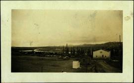
Showing 4377 results

Archival description
3218 results with digital objects Show results with digital objects
2006.20.12.45 · Item · [ca. 1940]
Part of Northern BC Archives Historical Photograph Collection

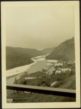
Handwritten photo album caption below this photo reads: "Another view from Tower at Whitehorse." Photograph depicts various unidentified buildings, vehicles, and machinery behind dirt road in mid ground. Power poles in foreground; trees, river, and mountains in background.

Royal Canadian Air Force
View from City Hall
2012.13.1.3.045 · Item · Jan. 1978
Part of J. Kent Sedgwick fonds

Image depicts a view of Prince George from City Hall looking northeast with the pulp mills in the background. Map coordinates 53°54'46.3"N 122°44'41.9"W

Veteran House
2012.13.1.24.36 · Item · 2000
Part of J. Kent Sedgwick fonds

Image depicts a property given to the Veterans of the Second World War, located on the corner of 15th Avenue and Elm Street in Prince George, B.C.

Vanderhoof
2012.13.1.51.017 · Item · May 1972
Part of J. Kent Sedgwick fonds

Image depicts a barn with large, Harvestore Systems. It is possibly located on one of the many farms near Vanderhoof, B.C.

Valemount
2012.13.1.85.25 · Item · [1976?]
Part of J. Kent Sedgwick fonds

Image depicts a view of Valemount, with numerous mountains in the background.

Urban Affairs
2009.6.13.32 · Subseries · 1974-1979
Part of The Honourable Iona Campagnolo fonds

Subseries consists of correspondence and accompanying informational material related to the Department of Urban Affairs and housing concerns. Records include newspaper clippings, reports, brochures and pamphlets, news releases, maps, and speeches from the Minister of Urban Affairs Barney Danson and others. Includes correspondence regarding urban transportation, federal housing grants and housing in Canada, mortgages and the Central Mortgage and Housing Corporation, public housing developments, inquiries and applications for grants, and student housing.

Upper Fraser Road in Winter
2012.13.1.89.016 · Item · Feb. 1973
Part of J. Kent Sedgwick fonds

Image depicts several unidentified individuals walking along the snow-covered Upper Fraser Road with numerous buildings on either side. Map coordinates 54°07'05.7"N 121°56'38.9"W

2012.13.1.87.041 · Item · [between 1975 and 1995]
Part of J. Kent Sedgwick fonds

Image depicts the Upper Fraser Road running through Upper Fraser, B.C. A beehive burner is seen in the background on the left and the mill office is seen on the right. Map coordinates 54°07'05.7"N 121°56'38.9"W

Upper Fraser Residences
2012.13.1.87.047 · Item · [between 1975 and 1995]
Part of J. Kent Sedgwick fonds

Image depicts an older building with numerous vehicles parked out front in Upper Fraser, B.C. Map coordinates 54°07'03.5"N 121°56'34.4"W

Upper Fraser Mill
2012.13.1.87.044 · Item · [between 1975 and 1995]
Part of J. Kent Sedgwick fonds

Image depicts entrance to mill yard for Upper Fraser mill in Upper Fraser, B.C. Map coordinates 54°07'10.8"N 121°56'51.7"W

Upper Fraser Mill
2012.13.1.87.046 · Item · [between 1975 and 1995]
Part of J. Kent Sedgwick fonds

Image depicts Upper Fraser mill yard with log deck and beehive burner in silhouette across railroad tracks. Located in Upper Fraser, B.C. Map coordinates 54°07'01.5"N 121°56'29.6"W

Upper Fraser Mill
2012.13.1.87.064 · Item · [between 1975 and 1995]
Part of J. Kent Sedgwick fonds

Image depicts numerous log decks at the Upper Fraser sawmill. Map coordinates 54°07'10.8"N 121°56'51.7"W

Upper Fraser Mill
2012.13.1.87.062 · Item · [between 1975 and 1995]
Part of J. Kent Sedgwick fonds

Image depicts the entrance to the Upper Fraser mill yard in Upper Fraser, B.C. Map coordinates 54°07'10.8"N 121°56'51.7"W

Upper Fraser Mill
2012.13.1.87.063 · Item · [between 1975 and 1995]
Part of J. Kent Sedgwick fonds

Image depicts the Upper Fraser mill yard with a CN train in Upper Fraser, B.C. Map coordinates 54°07'10.8"N 121°56'51.7"W

Upper Fraser Mill
2012.13.1.87.061 · Item · [between 1975 and 1995]
Part of J. Kent Sedgwick fonds

Image depicts the entrance to the Upper Fraser mill yard in Upper Fraser, B.C. Map coordinates 54°07'10.8"N 121°56'51.7"W

Upper Fraser Mill
2012.13.1.87.066 · Item · [between 1975 and 1995]
Part of J. Kent Sedgwick fonds

Image depicts the Upper Fraser Road running through Upper Fraser, B.C. A newer style round burner is seen in the background. Map coordinates 54°07'05.7"N 121°56'38.9"W

Upper Fraser General Store
2012.13.1.87.043 · Item · [between 1975 and 1995]
Part of J. Kent Sedgwick fonds

Image depicts the Upper Fraser General Store in Upper Fraser, B.C. Two other signs indicate that it is also a post office and a place that offers propane refills. Map coordinates 54°07'10.8"N 121°56'51.7"W

Unknown Family by House
2009.5.2.22 · Item · [ca. 1900]
Part of Taylor-Baxter Family Photograph Collection

Photograph depicts a man and woman standing beside an elderly woman on grass lawn. Wood boardwalk runs beside house, steps and porch featured on left. A jack russell terrier stands at their feet. Neighbouring yards in background.

Unknown Family by House
2009.5.2.25 · Item · [ca. 1900]
Part of Taylor-Baxter Family Photograph Collection

Photograph depicts a man and woman standing beside an elderly woman on wood boardwalk near front porch. Window plants hang beside them and a jack russell terrier sits at their feet. Neighbouring yards in background.

Unknown Family by House
2009.5.2.23 · Item · [ca. 1900]
Part of Taylor-Baxter Family Photograph Collection

Photograph depicts a man and woman standing beside an elderly woman on boardwalk running alongside house. Window plants in foreground, neighbouring yards in background. A jack russell terrier stands in left foreground.