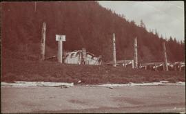
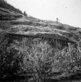
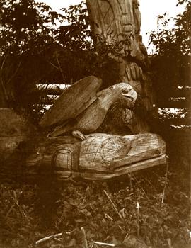
Carvings sit among bushes in front of what appears to be a totem pole.
Handwritten annotation on verso reads: "Eagle & whale Monument Tanu".
Carvings sit among bushes in front of what appears to be a totem pole.
Handwritten annotation on verso reads: "Eagle & whale Monument Tanu".
Totem poles (crest poles?) stand in front of a line of houses. Sandy beach in foreground, forest on hill in background.
Handwritten annotation on verso reads: "Kai sun W. Coast Q.C.I."
Photograph depicts tall building, with long shorter section crossing midground in front. Path runs through garden in foreground.
Handwritten annotation on verso reads: "Back of Mission House Kincolith".
Photograph depicts two unidentified men sitting on front steps of large church. Building materials are scattered in foreground, and scaffolding is visible on one tower.
Handwritten annotations above and below image read: "Dimensions of 73 Feet in length by 37 Feet in width exclusive of Porch and Buttresses. Destroyed by fire with 30 dwelling houses. The spire had been completed when burnt."; "Kincolith Church, Nth. W. Coast. British Columbia within 5 miles of the Alaskan Coast, was destroyed by fire"
Greeting card reads: "Kincolith Church. Wishing you all a very happy Xmas. Your work shall be rewarded. II Chron. XV. 7. [illegible initials]".
Photograph depicts two men standing beside beds of fish laid out to dry. More oolichan fish hang on tall structures in background.
Handwritten annotation on verso reads: "'Food for winter' Oolichans drying at Fishing Bay, Nass River".
Photograph depicts groups of men gathered on ice. One man sits on ice sled in foreground. Village can be seen on shore in background.
Handwritten annotation on verso reads: "Chapt. II. No. 1. Fishing Bay. Olachan fishery on the ice."
Three men can be seen carrying bundles across bridge above river, forest on shore in background.
Handwritten annotation on verso reads: "Upper Nass River. Chapt. XXII. No. 4. An Indian Bridge on a canyon."
Group of eight men and seven children stand in front of crest pole on unidentified building.
Handwritten annotation below image reads: "[..?] Alaska. Indian Totem Pole, Eagle Crest South Eastern Alaska."; on verso: "Chapter XXI Illustrations No. 2. [Kinnanook?] Section of Indian Village showing Totem pole of Eagle crest."
Photograph depicts community buildings on shoreline, water in foreground.
Handwritten annotation on image reads: "Wrangle, Alaska."; on verso: "Fort Wrangle, Alaska Territory. visited by W.H.Collison, C.M.S. 1877. Prior to the establishment of any mission, [...? illegible] 1875 - 1876. Presbyterian. Insert this illustration of Wrangle on Page 77 as marked."
Photograph depicts a copy of a June 1915 photograph that shows five men in front of the Terrace Land Company building. From left to right, these people include: J.K. Gordan of Terrace, John Oliver (future BC Premier), H.C. Brewster (future BC Premier), L.H. Kenney of Terrace, and T.D. Pattullo.
Photograph depicts a log house in winter built by B.C. Remote Housing in Good Hope Lake.
Photograph depicts Iona Campagnolo, men, and teenagers at a construction site with a building frame, possibly for a Young Canada Works project.
Photograph depicts an unknown man with a chainsaw cutting a window frame in a house under construction.
Photograph depicts Iona Campagnolo's assistant and an unknown man conferring about the installation of a window in a house under construction.
Photograph depicts Iona Campagnolo's assistant standing beside a newly installed window in a house under construction.
Photograph depicts the construction of the Queen Charlotte Islands museum at Skidegate by a residence.
Photograph depicts the Queen Charlotte Islands museum site overlooking Skidegate Inlet and next to a gravel beach.
Photograph depicts an artist's representation of a proposed skating rink facility where the barriers are removed to illustrate community skating around the central core.
Photograph depicts a liquor store and church on Main St. in Lillooet, B.C.
Photograph depicts a courthouse in Vancouver, B.C. Photo shows the ripped up forecourt.
Photograph depicts a deserted cannery at Nootka, on west Vancouver Island.
Photograph depicts the Pacific Terminus of the Trans Canada Highway in Tofino, B.C. on Vancouver Island.
Photograph depicts a house fire possibly on 1000 Beach Block and Thurlow St. , caused by a wrecking gang.
Photograph depicts homes on 1000 Beach Ave., looking northeast.
Photograph depicts the ongoing wrecking of house #1053 on Beach Ave.
Photograph depicts the homes on 1000 Beach Ave. in Vancouver, B.C.
Photograph depicts the city hall at New Westminster on Victoria Day. The anvil battery is about to fire a 21 gun salute.
Photograph depicts the city hall at New Westminster on Victoria Day. The anvil battery firing round #3 of 21 gun salute.
Photograph depicts the Vancouver Shipyards Ltd. on 555 Denman St. in Vancouver, B.C., looking south from Coal Harbour waters.
Photograph depicts the west end of Coal Harbour looking south to West Georgia St. and Chilco-Gilford block beyond. The old pilings exposed at low tide.
Photograph depicts a wooden irrigation flume on the west side of Oliver in the Osoyoos fruit valley, near #18 Rd.
Photograph depicts Simon Fraser University in Burnaby, B.C., 1 week after the official opening.
Photograph depicts Simon Fraser University in Burnaby, B.C., one week after the official opening.
Photograph depicts the Hospital Cottage on Main St. in Sechelt, B.C. which also appears to have been home to the Magistrates and Small Debts Court at one point. A large central hospital for the whole of the Sechelt Peninsula was opened in 1965 at Sechelt.
Photograph depicts Cadero St. in the west end of Vancouver, looking north from Barclay St. intersection in the 800 block.
Photograph depicts a mine 200 yards south of Moyie village, which is 20 miles south of Cranbrook. It produced silver, zinc, and lead from 1900-1910 and had a smelter a quarter mile away. The shaft was 900 ft. deep, with levels going under Moyie Lake. The head gear dates from 1925-1935 and has electric winding.
Photograph depicts a Ruston steam roller owned by Gary Wellburn in Duncan, BC
Photograph depicts the C.P.R. Shuswap Depot east of Kamloops.
Photograph depicts the water tower at the C.P.R. Savona Depot. The view is looking east towards Kamloops.
Photograph depicts a disused water tower 50 yards from the C.P.R. Shuswap Depot, looking west towards Kamloops.
Photograph depicts the C.P.R. Savona Depot looking east.
Photograph depicts the C.P.R. wharf-scow approach ramp at Kelowna, looking east. Okanagan Lake is behind the camera.
Photograph depicts the C.P.R. station at North Bend, B.C., from a view looking north.
Photograph depicts the C.P.R. station at Spences Bridge. The view is looking south at a departing freight train.
Photograph depicts the C.P.R. Glacier Station at the entrance to the west portal of Connaught tunnel under Rogers Pass. The station was built of logs about 1916-1920. The view is looking west.
Photograph depicts the C.P.R. station at Invermere on the Golden-Cranbrook line, looking southwards. It is called the "Lake Windermere Station" built in 1916 of logs. The last mixed passenger train ran in 1962.
Photograph depicts the C.P.R. depot at Canal Flats on the Golden-Cranbrook line. The ex box car depot now is used only to make line phone calls.
Photograph depicts the C.P.R. station at Invermere in the Kootenays. There is a trolley off the track on the road and the way freight switching at the station. Golden is to the left, Cranbrook is to the right, and the station building is at the immediate left.