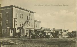
Mostrar 887 resultados

Archival description
887 resultados com objetos digitais Mostrar resultados com objetos digitais
Third Avenue, Prince George, BC
2011.3.2.27 · Item · [ca. 1910-1924]
Parte de North Coast & Central BC Postcard Collection

Photograph taken from the intersection of 3rd Avenue and an unidentified street. Visible businesses include "Ben Baird The Smart Shop" and "C.N.R. Cafe." Printed annotation on recto reads: "3rd Ave. PR. George, B.C."

Prince George to Tete Jaune
2011.3.4.14 · Item · [ca. 1901-1915]
Parte de North Coast & Central BC Postcard Collection

Stern wheeler in river. Handwritten annotation in pencil on verso reads: “Prince George to Tete Jaune” Hand written message in ink on verso is addressed to “Mademoiselle Elisabeth Joliet, Terrguy – Les Dijore Cote a Or France”

Fraser River
2012.13.1.3.002 · Item · Oct. 1970
Parte de J. Kent Sedgwick fonds

Image depicts the Fraser River from Northwood Road in the Prince George area.

Tabor View
2012.13.1.3.003 · Item · Oct. 1970
Parte de J. Kent Sedgwick fonds

Image depicts a view of Tabor Mountain in Prince George, B.C.

From Cutbanks
2012.13.1.3.005 · Item · Apr. 1972
Parte de J. Kent Sedgwick fonds

Image depicts the Fraser River from the vantage point of the cutbanks in Prince George, B.C.

McMillan Creek Valley
2012.13.1.3.009 · Item · Apr. 1972
Parte de J. Kent Sedgwick fonds

Image depicts part of the McMillan Creek Trail in the McMillan Regional Park in Prince George, B.C.

Farmhouse
2012.13.1.3.012 · Item · Apr. 1972
Parte de J. Kent Sedgwick fonds

Image depicts a farmhouse on Old Summit Road in Prince George, B.C.

Peden Hill
2012.13.1.3.020 · Item · Oct. 1975
Parte de J. Kent Sedgwick fonds

Image depicts a view of Peden Hill in Prince George, B.C.

Highway 97
2012.13.1.3.021 · Item · Oct. 1975
Parte de J. Kent Sedgwick fonds

Image depicts Highway 97 at 15th Ave. looking north. Map coordinates 53°54'36.0"N 122°46'55.5"W

Highway 97
2012.13.1.3.022 · Item · Oct. 1975
Parte de J. Kent Sedgwick fonds

Image depicts Highway 97 at 15th Ave. looking north. Map coordinates 53°54'42.1"N 122°46'53.1"W

Sprawl
2012.13.1.3.026 · Item · Oct. 1975
Parte de J. Kent Sedgwick fonds

Image depicts a few houses, most likely near the airport in Prince George, B.C.

Trailers for Sale
2012.13.1.3.027 · Item · Oct. 1975
Parte de J. Kent Sedgwick fonds

Image depicts mobile homes for sale on Cowart Road looking northeast with Simon Fraser Bridge in background. Map coordinates 53°52'39.3"N 122°46'13.1"W

Tabor Mountain
2012.13.1.3.028 · Item · Oct. 1975
Parte de J. Kent Sedgwick fonds

Image depicts Tabor Mountain from the airport in Prince George, B.C.

Woodwards
2012.13.1.3.029 · Item · Oct. 1975
Parte de J. Kent Sedgwick fonds

Image depicts Parkwood Place taken from Connaught Hill looking west with the hospital in the background. Map coordinates 53°54'39.9"N 122°45'02.5"W

Cache Walk
2012.13.1.3.035 · Item · Oct. 1976
Parte de J. Kent Sedgwick fonds

Image depicts a nature trail along the Nechako River at Island Cache looking west with the cutbanks in the background. Map coordinates 53°55'36.2"N 122°45'11.8"W

Agriculture
2012.13.1.3.036 · Item · Nov. 1977
Parte de J. Kent Sedgwick fonds

Image depicts an agricultural field, most likely near Prince George, B.C.

Powerline
2012.13.1.3.037 · Item · Nov. 1977
Parte de J. Kent Sedgwick fonds

Image depicts power lines east of the pulp mills in Prince George, B.C.

Natural Meadows
2012.13.1.3.038 · Item · Nov. 1977
Parte de J. Kent Sedgwick fonds

Image depicts natural meadows, possibly east of Prince Georg, B.C.

Prince George
2012.13.1.3.042 · Item · Nov. 1977
Parte de J. Kent Sedgwick fonds

Image depicts downtown Prince George looking northwest across Dominion Street. Map coordinates 53°54'48.7"N 122°44'45.6"W

Logging
2012.13.1.3.043 · Item · Nov. 1977
Parte de J. Kent Sedgwick fonds

Image depicts an area undergoing logging somewhere in Prince George, B.C.