Mostrar 4830 resultados

Archival description
4073 resultados com objetos digitais Mostrar resultados com objetos digitais
Railway workers on Pacific Great Eastern #52 locomotive
2020.08.88 · Item · [between 1913 and 1923]
Parte de Pacific Great Eastern Railway Region Photograph Collection

Photograph depicts Pacific Great Eastern Railway #52 locomotive with railway workers posed on the locomotive for a posed portrait.

More information about the locomotive:
Pacific Great Eastern #52 locomotive was built by Montreal Locomotive Works in 1913 and delivered to the PGE in November of that year together with a second identical locomotive, Pacific Great Eastern #51. They were relatively light road locomotives of the Consolidation type (2-8-0 wheel arrangement) and, prior to dieselization of the railway in the late 1940s - early 1950s, were the only Montreal-built locomotives the railway owned. All subsequent steam locomotives built new for the Railway came from the Canadian Locomotive Company in Kingston, Ontario. There were also two earlier second-hand locomotives which the PGE acquired when it took over the Howe Sound & Northern Railway (previously the Howe Sound, Pemberton Valley & Northern Railway) and two additional steam locomotive purchased second-hand from the U.S.

Alta Lake
2020.08.84 · Item · [between 1913 and 1923]
Parte de Pacific Great Eastern Railway Region Photograph Collection

Photograph depicts a couple in a row boat (likely the same couple depicted in image 2020.08.59) near Alta Lake shore docks and buildings. A rail line and a railway water tower are visible in the background. The water tank is a typical PGE 25,000 gallon water tank. The station would be a little over 400 feet south of the tank and is hidden by the stand of trees.

Pacific Great Eastern Railway train at Squamish dock
2020.08.03 · Item · [between 1915 and 1918]
Parte de Pacific Great Eastern Railway Region Photograph Collection

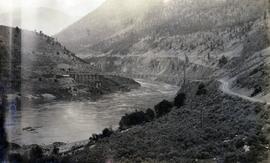
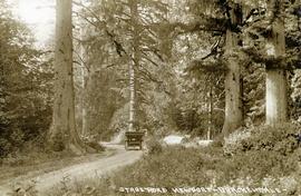
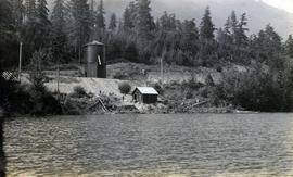
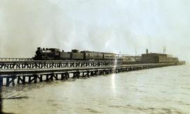
Photograph depicts a Pacific Great Eastern Railway train on the original dock at Squamish (Newport); the vessel in the distance behind the warehouse is quite likely the "MV Ballena", the subject of photograph 2020.08.01.

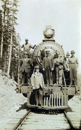
The equipment shown in this photograph is: Locomotive 51 or 52, built by Montreal Locomotive Works in 1913; caboose C-1, built by National Steel Car, Hamilton, Ontario in 1914; baggage-mail car 51 or 52; passenger coach 2, 3 or 4; and an unknown flat car outfitted as a sightseeing car with canopy. The time-frame for the photograph is between June 8, 1915 (when baggage-mail cars 51 & 52 arrived at Newport Dock) and some time in 1918 (when caboose C-1 was re-numbered to 1801).

Additional information on baggage-mail cars 51 & 52 and coaches 2, 3 & 4:
Baggage and mail cars 51 and 52 were purchased from E.H. Wilson & Co. of Philadelphia at a total cost of $2806.74 each. They were received on line June 4, 1915 and were barged to Newport on June 8. These cars had a length of 64 ft. over buffers, an inside length of 60 ft. and an inside width of 9 ft. 2½ in. and rode on 6-wheel trucks. Although not confirmed, these cars are believed to be of Pennsylvania Railroad heritage with PRR Class MM baggage and mail cars being the most likely candidates. Certainly, all the other cars purchased from E.H. Wilson & Co. were ex-Pennsylvania and the gasoline lighting system with which these cars were delivered was used extensively by the PRR.

Coaches 2, 3, & 4 are former Pennsylvania Railroad Class “PK” closed vestibule coaches #s 3077, 3080, & 3092 which were received on June 10, 1914 after being purchased from E.H. Wilson & Co. for $3859.11, $3858.87 & $3858.87 respectively. They were built by the PRR in 1905, 3070 and 3088 at Altoona Car Shops and 3092 at the Wilmington, Delaware shops of subsidiary Philadelphia, Baltimore and Washington. All had been assigned to P.B. & W. service. The Official Railway Equipment Register lists these cars as 62 ft. long with a capacity of 60 passengers.

Passenger ferry "MV Ballena"
2020.08.01 · Item · [between 1914 and 1920]
Parte de Pacific Great Eastern Railway Region Photograph Collection

Photograph depicts the "MV Ballena" docked at a wharf. The Ballena was a passenger ferry built in 1892 by the Albion Iron Works Company of Victoria and originally named the Joan. This ship was sold to the Terminal Steam Navigation Company in 1914 and renamed the Ballena. It was later acquired by the Union Steamship Company in 1920 but burned at the Union dock in November of that year.

PGE Railway tunnel along Anderson Lake
2020.08.25 · Item · [between 1913 and 1923]
Parte de Pacific Great Eastern Railway Region Photograph Collection

Photograph depicts a Pacific Great Eastern Railway tunnel along Anderson Lake. The current railway mileage for the location is 125.6 (historical mileage point would have differed). The location is 3.7 miles north of D'Arcy, near the southern end of Anderson Lake. This photograph was likely taken from vantage point of the summer-only Highline Road.

Esquimalt & Nanaimo Railway, Courtenay
2013.6.36.1.140.03 · Item · Sept. 2001
Parte de David Davies Railway Collection

Photograph depicts Esquimalt & Nanaimo Railway trackage in Courtenay. In another 200 yards, it was the northerly point the railway ever reached. Both lines were not in use north of the Courtenay station. The line on the left was the main one, while the one on the right was an industrial spur or siding.

Crestbrook Forest Industries Operations
2012.13.1.122.34 · Item · July 1982
Parte de J. Kent Sedgwick fonds

Image depicts a man attaching a logging trailer to a crane on a wooden structure to stack the trailer on the truck. A Crestbrook Forest Industries sawmill is located in the background.

Forestry Heavy Machinery
2012.13.1.122.30 · Item · May 1980
Parte de J. Kent Sedgwick fonds

Image depicts several pieces of heavy machinery used in forestry. The Coast Inn of the North is seen in the background.

Forestry Heavy Machinery
2012.13.1.122.29 · Item · May 1980
Parte de J. Kent Sedgwick fonds

Image depicts several pieces of heavy machinery used in forestry. The Coast Inn of the North is seen in the background.

Suspended Trailer
2012.13.1.122.09 · Item · Oct. 1975
Parte de J. Kent Sedgwick fonds

Image depicts a trailer for a logging truck suspended off the ground by a wooden structure. This is used to load the trailer onto the back of the truck. The name on the truck says "Rormarniewich Trucking Ltd."

Train on Hansard Bridge
2012.13.1.89.137 · Item · 1999
Parte de J. Kent Sedgwick fonds

Image depicts a train on the Hansard Bridge across the Fraser River looking west. Map coordinates 54°04'37.7"N 121°50'39.9"W

Building in Upper Fraser, BC
2012.13.1.89.018 · Item · Feb. 1973
Parte de J. Kent Sedgwick fonds

Image depicts a vehicle parked beside a small, wooden house in Upper Fraser, B.C. Map coordinates 54°07'05.7"N 121°56'38.9"W

Giscome Parking Lot
2012.13.1.87.174 · Item · [between 1975 and 1995]
Parte de J. Kent Sedgwick fonds

Image depicts a parking lot full of vehicles with the Giscome store in the background. Map coordinates 54°04'18.5"N 122°21'57.7"W

Giscome Street Scene
2012.13.1.87.173 · Item · [between 1975 and 1995]
Parte de J. Kent Sedgwick fonds

Image depicts a street in Giscome B.C. The Giscome Store is located on the left side of the image with the church in the background. Map coordinates 54°04'18.5"N 122°21'57.7"W

Giscome CN Station
2012.13.1.87.161 · Item · [between 1975 and 1995]
Parte de J. Kent Sedgwick fonds

Image depicts the old CN station in Giscome, B.C. Map coordinates 54°04'20.7"N 122°22'01.1"W

Trains at Giscome Mill Site
2012.13.1.87.153 · Item · [between 1975 and 1995]
Parte de J. Kent Sedgwick fonds

Image depicts several trains at the Giscome mill site in Giscome, B.C. Map coordinates 54°04'19.7"N 122°22'04.7"W

Street in Giscome - After
2012.13.1.87.094 · Item · [between 1980 and 2000]
Parte de J. Kent Sedgwick fonds

Image depicts a street in Giscome. The store was previously located on the left. The church is in the background. Map coordinates 54°04'18.5"N 122°21'57.7"W

Employee Houses on Giscome Mill Site
2012.13.1.87.088 · Item · [between 1980 and 2000]
Parte de J. Kent Sedgwick fonds

Image depicts employee houses on mill site in Giscome, B.C. Tug boats are in the foreground on the right. Map coordinates 54°04'23.4"N 122°22'16.9"W

Giscome - Train Tracks - After
2012.13.1.87.087 · Item · [between 1975 and 1995]
Parte de J. Kent Sedgwick fonds

Image depicts the Giscome mill site in Giscome, B.C. The railroad tracks are in the foreground. Map coordinates 54°04'17.6"N 122°22'06.1"W

Giscome Houses and Railway Tracks
2012.13.1.87.078 · Item · [between 1975 and 1995]
Parte de J. Kent Sedgwick fonds

Image depicts the Giscome railway station and buildings remaining in townsite in Giscome, B.C. Map coordinates 54°04'18.0"N 122°22'04.7"W

Old Road to Giscome Townsite
2012.13.1.87.076 · Item · [between 1975 and 1995]
Parte de J. Kent Sedgwick fonds

Image decpicts the old road to the townsite in Giscome, B.C. Map coordinates 54°04'19.7"N 122°22'04.7"W

Houses and Train in Giscome
2012.13.1.87.073 · Item · [between 1975 and 1995]
Parte de J. Kent Sedgwick fonds

Image depicts the Giscome B.C. townsite from across the railroad tracks looking southeast. Map coordinates 54°04'19.7"N 122°22'04.7"W

Upper Fraser Mill
2012.13.1.87.066 · Item · [between 1975 and 1995]
Parte de J. Kent Sedgwick fonds

Image depicts the Upper Fraser Road running through Upper Fraser, B.C. A newer style round burner is seen in the background. Map coordinates 54°07'05.7"N 121°56'38.9"W

Upper Fraser Mill
2012.13.1.87.063 · Item · [between 1975 and 1995]
Parte de J. Kent Sedgwick fonds

Image depicts the Upper Fraser mill yard with a CN train in Upper Fraser, B.C. Map coordinates 54°07'10.8"N 121°56'51.7"W

Upper Fraser Mill
2012.13.1.87.062 · Item · [between 1975 and 1995]
Parte de J. Kent Sedgwick fonds

Image depicts the entrance to the Upper Fraser mill yard in Upper Fraser, B.C. Map coordinates 54°07'10.8"N 121°56'51.7"W

Upper Fraser Mill
2012.13.1.87.061 · Item · [between 1975 and 1995]
Parte de J. Kent Sedgwick fonds

Image depicts the entrance to the Upper Fraser mill yard in Upper Fraser, B.C. Map coordinates 54°07'10.8"N 121°56'51.7"W

Upper Fraser Road in Upper Fraser, BC
2012.13.1.87.041 · Item · [between 1975 and 1995]
Parte de J. Kent Sedgwick fonds

Image depicts the Upper Fraser Road running through Upper Fraser, B.C. A beehive burner is seen in the background on the left and the mill office is seen on the right. Map coordinates 54°07'05.7"N 121°56'38.9"W