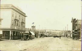
Photograph of George Street in Prince George B.C. Cars, people, and signage are visible. Printed annotation on recto reads: “George St. Prince George B.C. 1921 R7 by Moore” There is an “X” in ink over the fire hall. Handwritten annotation in ink on verso reads: “This view is also looking north and where I have put the X is the one and only fire hall and you can see the fire engine in the street. This is the main street.”
Photograph depicts two women with flowers and three men standing on grass and boardwalk in foreground, large building in background.
Handwritten annotation on verso: “Government Agency at S. Fort George 1922."
Photograph depicts hotel on corner of street, crowd and cars in foreground.
Handwritten annotation on verso “Albert Johnson’s 'Northern Hotel' South Fort George 1914".
Photograph depicts two men standing in front of very small wood building with tarp-covered roof. Chair and paper documents can be seen in front of building, trees and rough cleared land in background.
Handwritten annotation on verso: “The first newspaper office, South Fort George 1910."
This photograph collection consists of 53 photographs featuring primarily Giscome with a few of Prince George. Subjects include the Eagle Lake Sawmill, Eagle Lake, Giscome townsite (including specific buildings and general road perspectives), Giscome School, Division II class photos (1950-51), and the Giscome School teacherage.
Image depicts Highway 97 at 15th Ave. looking north. Map coordinates 53°54'42.1"N 122°46'53.1"W
File consists of a transcript of an oral history interview with Steve Kolida.
File consists of a transcript of an oral history interview with Earl Lousier and Harry Gairns.
File consists of a transcript of an oral history interview with Jean May.
File consists of a transcript of an oral history interview with Horst Sander. Also includes photocopies of Horst Sander's personal records, such as a tree farm license.
File consists of a transcript of an oral history interview with John and Bernice Trick.
File consists of a transcript of an oral history interview with Crissie Ward and Laureen Stewart.
File consists of an audio recording of an interview with Ivan and Bev Westerland. Includes two original recorded audio cassettes and two copies.
File consists of a transcript of an oral history interview with Kate Anderson and Mae Romanin.
File consists of a transcript of an oral history interview with Jack Boudreau. Also includes photocopies of Jack Boudreau's personal records, such as the Diary of Ada (Adelia) Sykes.
File consists of an audio recording of an interview with Ivan Andersen. Includes one original recorded audio cassette and one copy.
File consists of an audio recording of an interview with Jack Boudreau. Includes one original recorded audio cassette and one copy.
File consists of an audio recording of an interview with Lea Gobbi and Kate Anderson. Includes two original recorded audio cassettes and two copies.
Image depicts a marching band with numerous other unidentified individuals. One man is carrying a Canadian flag with the depiction of men in a boat and the words "Canada Sea-to-Sea" on it.
Image depicts a marching band with numerous other unidentified individuals. One man is carrying a Canadian flag with the depiction of men in a boat and the words "Canada Sea-to-Sea" on it, and there is a mascot beside him that appears to be a chipmunk in an RCMP uniform.
Image depicts a marching band with numerous other unidentified individuals. One man is carrying a Canadian flag with the depiction of men in a boat and the words "Canada Sea-to-Sea" on it.
Image depicts a group of individuals standing on the corner of 3rd Ave in Prince George, B.C.
Kent Sedgwick’s research subject files contain original research notes, interviews and oral histories, news clippings, and collected primary and secondary sources. The series also includes both original and reproduction photographs, audio recordings, and maps. The subject files primarily relate to the history, urban planning, and historical geography of the Central Interior of British Columbia, especially Prince George area and the East Line communities over the course of the 20th century. They also include extensive notes on geographic features, landscapes, interpretative trails, architectural history, industrial history, history of Western exploration and land survey, and the First Nations history of the region.
Subseries consists of material collected and created by Kent Sedgwick for research regarding various areas within Prince George. These files include material on neighbourhoods and notable areas within the city, as well as the Regional District of Fraser-Fort George. Notable areas include the Fort George Canyon, downtown Prince George, and Cottonwood Island. The files primarily contain notes and newspaper clippings relating to the development and history of these areas.
Subseries consists of materials collected and created by Kent Sedgwick for research on prominent individuals within Prince George and northern/central British Columbia. These individuals include various photographers, John Warren Meyer, Fannie Kinney, Father Adrien Morice, Henry Spencer Palmer, and Bridget Moran. The files also contain various other obituaries and materials regarding prominent individuals in Prince George.
Subseries consists of material collected and created by Kent Sedgwick for research regarding parks and outdoor recreation in Prince George. Material on parks includes Fort George Park (renamed to Lheidli T’enneh Memorial Park in 2015); Cottonwood Island Park; Connaught Hill; Moore's Meadow; L.C. Gunn Park; the Nechako Cutbanks; Paddlewheel Park; Monkman Provincial Park; Fraser Canyon Park; and Carp Lake. Also includes information on the creation of plaques and monuments, including the Alexander Mackenzie monument; the “Arrival of Steel” CN railway plaque; heritage interpretative signs for the Grand Trunk Pacific Railway; the Millar addition; and flooding and rivers. The files consists of various pamphlets and correspondence regarding the development of parks and the creation of interpretive materials.
Item is a hand drawn and coloured map by the City of Prince George Planning Department depicting North Nechako neighbourhood area existing land use in 1976.
Item is a hand drawn and coloured map by the City of Prince George Planning Department depicting the College Heights and southwest (Vanway) neighbourhood area existing land use in 1976.
Item is a map depicting a future low density development plan for the Peden Hill neighbourhood in Prince George.
Item is a map depicting a future high density development plan for the Peden Hill neighbourhood in Prince George.
Item is a map depicting the areas of winter shadow in the Peden Hill neighbourhood in Prince George.
Item is Map 1 of a group of five maps relating to a City of Prince George Study of Construction Aggregates by the firm Willis, Cunliffe, Tair & Company Limited. Map 1 shows development areas and population for 1984 and 1994. As the map is undated, it is unclear whether the 1984 and 1994 dates are future estimates.
Item is Map 4 of a group of five maps relating to a City of Prince George Study of Construction Aggregates by the firm Willis, Cunliffe, Tair & Company Limited. Map 4 shows development areas, aggregate sources, and requirements for 1984 and 1994. As the map is undated, it is unclear whether the 1984 and 1994 dates are future estimates.
This map is part of Schedule B of the 1993 Official Community Plan, Bylaw No. 5909 for the City of Prince George. This particular map reflects the 1998 amendment to the Official Community Plan.
This map depicts the City of Prince George's plan for soil removal and deposit.
This map is part of Schedule B of the 1993 Official Community Plan, Bylaw No. 5909 for the City of Prince George. This particular map reflects the 1998 amendment to the Official Community Plan.
This map is the May 2008 amendment (Bylaw 8061) of the Schedule C of the 2001 Official Community Plan, Bylaw No. 7281 for the City of Prince George. This Schedule C map shows the long range land use for the City of Prince George.