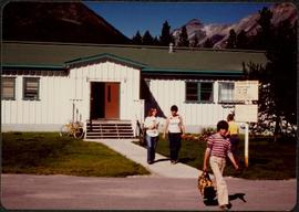
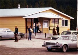
Photograph depicts unidentified men and women in front of yellow building with the signs "POST OFFCE / BUREAU DE POST / CASSIAR, B.C.", "NO PARKING". Three cars (one with siren on top) can be seen in foreground; forest in background.
Photograph depicts four unidentified individuals walking in front of Cassiar Private Hospital. Sign in foreground reads "VISITING HOURS EVERY DAY / 2 PM - 4 PM / 7 PM - 8 PM".
Photograph depicts group of children standing in front of diving board, watching a peer dive into water below. Group of swimmers visible in background below domed roof of pool.
Photograph depicts two unidentified men playing tennis in foreground. Buildings stand in midground, including what appears to be the All Saints Anglican Community Church. Forest and mountain in background.
Photograph depicts church believed to be the All Saints Anglican Community Church at Cassiar, B.C. Trees and fence in foreground, forest and mountain in background.
Photograph depicts two unidentified men wearing coveralls, hard hats, and headphones, while working at table in garage. Blasthole drill stands behind them in background.
Photograph depicts large trailer truck parked at what is believed to be the loading station on the Cassiar plant (possibly in mill building).
Photograph depicts the old company store located at corner of Connell Driver and Creery Street. Retail store was located under company cafeteria "the Cookery", with butcher shop in back. The Cookery was known for serving good food and providing excellent service.
Photograph depicts group of eight men standing on front steps of Cassiar's Main Office building. Top, left to right: Ken A. Creery, John Drybrough. Middle, left to right: John E. Kennedy, Tam Zimmermann. Bottom, left to right: Fred Martin Connell, George Washington Smith, W. Harold Connell, Charles Rainforth Elliot. Windows and doors to office in background, flowers in bottom right foreground. Photo believed to have been taken on the same day as items 2000.1.1.4.3.4 - 2000.1.1.4.3.6.
Photograph depicts group of nine men standing on lawn in front of building known as "House 130" or "Director's Lodge". Left to right: Andre Beguin, unknown, Charles Rainforth Elliot, Jack Christian, W. Harold Connell, Plato Malezemoff (from Newmont Mining), Tam Zimmermann, Ken A. Creery, Fred Martin Connell. Daffodils and tulips planted in foreground, trees and mountains in background. Most men featured in photo are believed to be members of Cassiar's Board of Directors; Beguin was a General Superintendent.
This blueprint depicts the general layout of the recreational centre. Top-down, side and front perspectives are used. The ground floor, second floor, outside walls and stage layouts are shown.
This blueprint depicts the outside layout of the recreation centre and includes its north, south, east and west elevations. Details are included regarding the materials to be used for construction.
This blueprint depicts the overall framing structure of the recreational centre. Details include a cross section layout of the recreational centre with relevant framing dimensions, the locations and instructions for assembly as well as types of framing materials to be used.
Blueprint of the Cassiar Recreational Centre depicting various details regarding aspects of the building. Perspectives included within the blueprint are top-down as well as cross-sections. There are notes by the architect towards how certain building aspects and details are to be found and built throughout the blueprint. There are annotations located throughout the blueprints written in gold pen and pencil regarding certain errors, changes and further clarification on various aspects of the building from the original plans. Numerical annotation at the bottom right hand of plan imposed new numbering system (3002/09/06 to 12 repectively).
This blueprint depicts the detailed plans for the recreational centre's entrance hall. There are details pertaining to the elevation of entrance doors, the overall plan of the entrance hall, the upper level staiwell as well as handrailing details. Annotations in gold pen and pencil regarding clarification and changes to certain details are included. Numerical annotation at the bottom right hand of plan imposed new numbering system (3002/09/08).
This blueprint depicts the overall layout of the heating and ventilating units to be used for the first and second floor of the recreational centre. Details include the locations of fans, boilers, ducts and exhausts as well as typical heating connector connections and the plumbing layout. Annotations in gold pen and pencil regarding clarification and changes to certain details are included. Numerical annotation at the bottom right hand of plan imposed new numbering system (3002/09/11).
Handwritten photo captions below this item and item 2000.1.1.2.324: "ELEVATION OF SITE: 6000' " "Two views of completed Crusher Bldg." Crane numbered "151" stands above and to right of crusher building. Snowdrift in foreground, mountain range in background.
Photograph depicts construction worker walking up mountain slope, possibly using rope safety gear. Wood framework for Crusher building in foreground; mine road, plant site, and mountain range in background.
Photograph depicts framework of one side of the crusher building next to rocks from excavated mountain wall. Lumber in foreground. Handwritten caption beside this photo reads: "Note confined area to work in, and need for rock fences."
Photograph depicts men working on different levels of construction site, some in dangerous areas, one man driving unidentified machinery in foreground. Long hose in right of image. View facing into the mountain.
Men working among lumber at crusher building site, ladders and various materials scattered around them.
Men working among lumber at crusher building site, various materials scattered throughout. Vertically protruding planks from framework of crusher building are in foreground. Tree-covered valley in background. Construction of a long structure near the edge of the excavation area can be seen in midground; this is speculated to be the section of the crusher building which housed conveyor "B".
Men standing behind saw horses on bottom level of crusher building site, lumber scattered throughout. View facing into mountainside.
View of crusher building from above, featuring the bottom level foundation. A dirt road and long building believed to be housing conveyor "B" cross the midground. Valley in background.
Photograph depicts man standing at bottom of crusher building. Portions of framework near top are covered with plastic. Snow on mountainside in background.
Handwritten caption beside this photo reads: "Lunchroom Damaged by Boulder". Large boulder stands to right of small building, walls of right corner partially destroyed. Lumber, upturned saw horse, and various other material lie on ground. Dirt road in foreground, mountainside in background.
Photograph depicts a construction worker carrying a plank of lumber across a higher level area of the construction site, semi-constructed walls below him. Barricades against loose rock are semi-visible in foreground (see item 2000.1.1.2.352).
Three men work in area confined by barricades made of vertical metal rods and horizontal wood planks (see item 2000.1.1.2.352). Two ladders in foreground, (one being used by construction worker). Lumber and semi-finished walls can be seen at higher level of elevation in background.
Handwritten caption beside this photo reads: "View of completed building." Large door on side of building, offering view of interior. Miscellaneous material in snowy foregrounded area: tractor equipment, steel drum, lumber etc.
Handwritten annotation on recto of photograph: "FORMING FOOTING RETAINING WALL JULY 4/64." Photograph depicts construction workers
standing in forms for cement laid against mountain wall on high elevation of construction site. A retaining structure made with wood planks and rebar separates mountainside dirt from cement forms. A front end loader can be seen in midground, near unidentified building. Mountain range in background.
Handwritten annotation on recto of photograph: "POURING FOOTING RETAINING WALL JULY 4/64." Photograph depicts construction workers manually pouring cement into forms laid against mountain wall on high elevation of construction site. Cement is being transported by wheelbarrow. A retaining structure made with wood planks and rebar separates mountainside dirt from cement forms. A bulldozer can be seen in background, as well as a front end loader and back hoe tractor. Building at crusher site also in background.
Handwritten annotation on recto of photograph: "RETAINING WALL POUR JULY 9/64." Photograph depicts large unidentified machinery in front of the retaining wall under conveyor of crusher building. Boom of crane can be seen in midground on right. Crusher building in background, dirt road in foreground.
Handwritten annotation on recto of photograph: "FORMING FOOTING FOR TRANSFORMER HOUSE AUG 20/64." Photograph depicts construction workers standing in forms made of wood and rebar for cement footings. Lumber scattered throughout, mountain range in background.
Photograph depicts large square model of the new mill building that was built at the Cassiar plant site in 1970. Model is displayed on green material set on a platform in snowy area. Machinery modeled inside the structure is colour-coded. Mountain in background.
Photo depicts workers at construction site of Cassiar's new mill building.
Photograph depicts the Cassiar townsite in foreground. Mill, dry rock storage building, and tailings pile can be seen in background. Handwritten annotation on verso of photograph: "1958 [1961 crossed through]."
Photograph depicts the Cassiar plantsite in foreground, including the mill, dry rock storage building, tailings pile, and many other buildings. Townsite in midground, mountains in background. Handwritten annotation on recto of photograph: "Cassiar."
Photograph depicts the primary crushing plant in foreground. Mine road can be seen below, and plant is visible in distance. South mountains in background. Handwritten annotation on recto of photograph: "1961-1962".
Photograph depicts the mine road in valley bellow mine. Cassiar plant and tailings pile in foreground. Handwritten annotation on recto of photograph: "Oct. 25 / 65 4:25 PM."
Photograph depicts the Cassiar valley: town in foreground, plant and tailings pile in background. Mountain range visible in distance. Photograph was taken from above, facing east.
Photograph depicts the Cassiar valley: plant and tailings pile on left, town on right. Mountain range visible in distance. Photograph was taken from above, facing south.
Photograph depicts the town of Cassiar behind plant and tailings pile in foreground. Mountain range in background.
Photograph depicts the town of Cassiar in distance behind pit mine in foreground. South mountain range in background. Photograph was taken from the air, portion of plane visible in top left of image.
Photograph depicts the pit mine, and road in valley below. Town of Cassiar can be seen in distance at foot of south mountain range.
Photograph depicts the Cassiar mine in foreground, north east mountain range in background. Tramline station and crushing plant visible in foreground in front of pit. Photograph was taken from the air, portion of plane visible in top left of image.
Photograph depicts the Cassiar mine in foreground, north east mountain range in background. Tramline station and crushing plant visible in foreground, west of pit. Photograph was taken from the air, portion of plane visible in top left of image.
Photograph depicts unknown man driving bulldozer in foreground. Shop area in background, numerous haul trucks and dozers throughout. Old mine garage can be seen in center behind dozer, and the mine's West Peak rises on right behind shop buildings. Mountain range in background. Handwritten annotations on recto of photograph: "Cassiar Asbestos Corporation Limited. Cassiar B.C. Mining asbestos ore elevation approx 6000 ft. above sea level. McDame mountain, Northern British Columbia"; "Toronto Set"; "D - 336"; "-4 1/2 -". What appears to be framing measurements are annotated on verso.
Photograph depicts Wabco in left foreground in front of shop building, tractor, and miscellaneous supplies. Mine valley and mountains in background. Handwritten annotation on recto of photograph: "Cassiar B.C. 1970 June 23 by Tom Kiefer".
Photograph depicts a man in work clothes and hard hat standing with hands placed on the first of many tram buckets hanging in a line. Steel beam framework of station building rises above him. Handwritten annotation on recto of photograph: "[F1?] LOADING STATION EL. 5800". Photograph was glued to cardboard backing with the annotation: "1962".
Photograph depicts large dry rock storage building in foreground on left, mill in background, dryer building in right midground. Miscellaneous supplies in far right foreground, mountains visible in background. Handwritten annotation on verso of photograph: "Sept 1954". This photograph was originally stored inside duotang labeled "CASSIAR ASBESTOS CORPORATION LIMITED PHOTOGRAPHS 1954"; photo caption beneath this image: "40,000 Ton Dry Storage Building / Mill / Dryer Building".