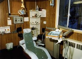
Photograph depicts examination chair and dental supplies. Winter scene visible through window in background.
Image depicts the interior of the historic Hudson's Bay Company Trading Post in Fort St. James, B.C.
Image depicts the interior of the historic Hudson's Bay Company Trading Post, with several unknown individuals present, in Fort St. James, B.C.
Image depicts what appears to be a motel somewhere near Bralorne, B.C.
Image depicts the Pride O' the North shopping mall in Prince Rupert, B.C.
Image depicts the abandoned and crumbling Forman's General Store somewhere in or near either Barkerville or Wells, B.C.
Image depicts the original bank building in Wells, B.C.
Photograph depicts unidentified men and women at counter in Royal Bank at Cassiar, B.C. Two employees stand behind counter.
Photograph depicts unidentified men and women in front of yellow building with the signs "POST OFFCE / BUREAU DE POST / CASSIAR, B.C.", "NO PARKING". Three cars (one with siren on top) can be seen in foreground; forest in background.
Photograph depicts unidentified man wearing apron while handling fruit in produce section of grocery store. Second individual semi-visible on far right.
Photograph depicts three unidentified individuals browsing magazine section of store.
Photograph depicts three unidentified women (two behind counter) at till in grocery store. "MEAT" and FROZEN FOOD" sections visible in background.
Handwritten annotation on verso reads: “CBC Time”.
Image depicts the interior of the historic Hudson's Bay Company Trading Post, with several unknown individuals present, in Fort St. James, B.C.
Image depicts a souvenir and gift shop for both Barkerville and Wells, B.C.
Image depicts the abandoned Cariboo Rooms, and a liquor store in Wells, B.C.
Image depicts the main street of Prince Rupert, B.C.
Image depicts a hotel in what appears to be a small community, possibly an outlying area of Bralorne, B.C.
Handwritten annotation on verso reads: “Summer / 80, S.F.U. + new life, first Jeans -”
Image depicts a building somewhere in Wells, B.C. There is a sign in one window which reads "Lon Oddfrey Insurance Realty LTD."
Image depicts an old building on the main street of Prince Rupert, B.C. Only half of the business name is visible: "Skeena Color [sic]."
Image depicts the Bank of Nova Scotia located on "Besner Block" in Prince Rupert, B.C.
Image depicts numerous vehicles and individuals outside a hotel in Likely, B.C.
Image depicts a hotel in Likely, B.C.
Image depicts the Hudson Bay Store in Quesnel, B.C.
Image depicts the Station Museum and the "Alberta Pool Elevators Ltd." building in Dawson Creek, B.C.
Image depicts a large building which is labelled "Alberta Pool Elevators Ltd. Dawson Creek," located in Dawson Creek, B.C.
Item consists of transcript of documentary consisting of forum with prominent members of the forest industry discussing the history of forestry in North Central British Columbia c.1960s-c.1980s. Participants include Bill Young, Keith Yorston, Ken Bernsohn, Hector Richmond, Russ Cousins, Harry Gairns, Don Gould, Orville Gorley, Frank Oberle, Includes 'logger's commandments' song.
Harkins, BobItem consists of transcript and tape summary of analog recording of interview with Bill Woycik and Howard Foot on the history of the Recreational Services Division of City of Prince George. Includes information on various events hosted including aquatic, circus and sports events c.1958-c.1986.
Harkins, BobMap is a "Recreation and Logging Road Guide to the Forest Lands of Vancouver Island Alberni Valley and the Surrounding Area" created for the public.
Item consists of transcript of interview with Ambrose Trick discussing the sawmilling and logging industry in Northern BC, c.1930s-1950s including the 1953 strike; the creation of the Northern Interior Lumbermen's Association. Trick also discusses his involvement in railway work, his involvement with hockey in Prince George and discusses Prince George politics, prominent personalities in the North.
Harkins, BobMap is a "Recreation and Logging Road Guide to the Forest Lands of Vancouver Island Alberni Valley and the Surrounding Area" created for the public. Backside states "Welcome to TFL 44", along with promotional imagery and information for backcountry travelers.
Item consists of interview with George Gibbons who discusses his working career with Prince George City Hall and as Alderman and Prince George's history c.1950s-c.1960s.
Harkins, BobItem consists of transcript and tape summary of interview with Ben Klassen, owner of Homesteader Meats. Also discusses hunting.
Harkins, BobItem consists of transcript and tape summary of interview with Elmer Nelson who discusses Axel Wenner- Gren's business interest in the Rocky Mountain Trench area of Northern British Columbia in the 1950s.
Harkins, BobImage depicts 3rd Ave at Victoria St. Map coordinates 53°55'03.9"N 122°44'54.8"W
Image depicts George St in downtown Prince George with City Hall in the background. Also visible are the Prince George Hotel and a movie theatre. Map coordinates 53°54'55.0"N 122°44'36.1"W
Image depicts George St in downtown Prince George with City Hall in the background. Also visible are the Prince George Hotel, Ming's Inn Chinese Restaurant, Fraser Stationers Ltd., Weiner King food cart, and a movie theatre. Map coordinates 53°54'55.0"N 122°44'36.1"W
Image depicts Pine Centre Mall in Prince George, B. C. Map coordinates 53°53'53.2"N 122°46'36.4"W
Item consists of printed transcript and tape summary of interview with Tony and Alma Skae who discuss their family's history in Stone Creek and later Prince George particularly in the newspaper and food and hospitality industry
Harkins, BobItem consists of interview with Joe Carty who discusses the trapping industry in the Prince George region
Harkins, BobImage depicts 3rd Ave at Victoria St. Map coordinates 53°55'03.9"N 122°44'54.8"W
Image depicts 3rd Ave at Victoria St. Map coordinates 53°55'03.9"N 122°44'54.8"W
Image depicts Central Street West, parallel to Highway 97 in Prince George, B.C. looking north. Shown: Prince George Motors and other car dealerships, Burger King, Grama's Inn, and the Spruceland Shopping Mall sign. Map coordinates 53°54'42.1"N 122°46'53.1"W
Item consists of printed transcript and tape summary of recorded interview with Carrie Jane Gray on controversy of Woodward's Department Store construction in Prince George
Harkins, BobImage depicts 3rd Ave at Victoria St. Map coordinates 53°55'03.9"N 122°44'54.8"W
Image depicts 4th Ave at Brunswick St. and the following businesses: Hart Drugs, The Yarn Barn, and Saveco. Map coordinates 53°54'59.9"N 122°44'52.9"W
Image depicts 4th Ave at Quebec St, showing the following businesses: The Yarn Barn, Golden Chalice Jewellers, Dandy Lines, Ultrasport, and Saveco. Map coordinates 53°54'58.6"N 122°44'47.5"W
Image depicts downtown Prince George, B.C.