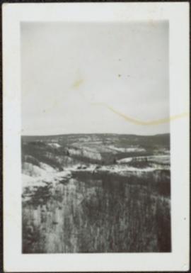
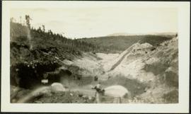
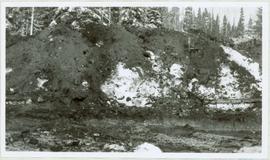
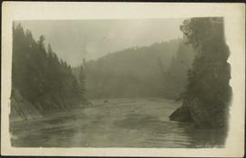
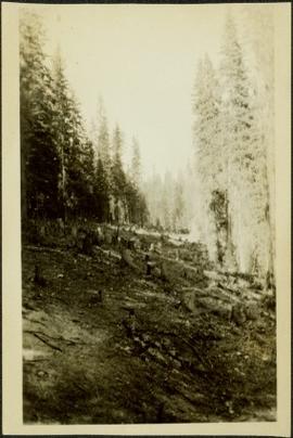
Photograph depicts dry creek bed, tall banks on either side. Hills and lake cross midground, mountains visible in background. Handwritten annotation on verso of photograph: "Looking down McKee Creek across Atlin Lake Towards Taku Glacier 6/27/37."
Photograph depicts the Atlin townsite, forest in foreground, hills in background. Town stands on edge of lake located in left midground. Handwritten annotation on verso of photograph: "Atlin City B.C., Sept. 3rd 1899. Copyrighted by S.A. Smythe Atlin, B.C."
Photograph depicts men and haul trucks visible in distance on snowy road in tree-covered hills.
Photograph depicts an unidentified building in snowy area, trees on hill in background.
Photograph depicts a car, bulldozer, and tractor speculated to be involved in road construction. Rough dirt road runs left of machinery, forest and hills in background.
Photograph depicts lumber and brush piles, forest in background. Crane semi-visible on left, small boat semi-visible on right.
Photograph depicts three men panning in stream, sluiceway behind them. Rocky banks in foreground, forest in background.
Photograph depicts man standing in front of large streams of water spraying from pipe into mining area, hills in background.
Photograph depicts sluice trunk in mining area, men on tall structure in background.
Photograph depicts young fruit trees planted in fenced area with small wind mill, hills in background. Handwritten annotation on recto of photograph: "This is part of the fruit trees if you place it along side of the other one you can see the location the farm buildings are on the other side I didn't get one of them."
Handwritten caption beside this photo reads: "Cookhouse in Winter". Photograph depicts top of building semi-visible behind large snow pile. Treetops can be seen in background.
Handwritten caption beside this photo reads: "Cutting Fire Wood". Photograph depicts two men on either side of large log using chain saw in wood clearing. A small snow-covered building can be seen in background.
Photograph depicts the excavation area in forest where dragline cranes had been operating.
Photograph depicts the load and main hook block of a dragline crane operating in excavation area of forest.
Handwritten caption beside this photo reads: "Fred Youngstron [sic?]" "Foreman spotting for operator." Photograph depicts one man seated on D8 Caterpillar operating a haulback rig, and a second man (Fred?) standing behind him on Caterpillar. Image quality is poor and faces are not visible. Dirt and debris in foreground, forest in background. It is believed this rig is operating in a long-line skidding system.
Handwritten caption beside this photo reads: "Earth Cut". Photograph depicts a man in distance at top of steep slope of man-made embankment, trees in background. Tracks made my machinery are visible in dirt of the cut.
Handwritten caption above this photo reads: "Earth Cut". Photograph depicts the steep slope of man-made embankment, trees in background. Tracks made my machinery are visible in dirt of the cut.
Five woman and one young girl pose on grass in front of palm trees.
Group of seven men and women stands in front of car in dirt road, forest in background. Sarah Glassey stands on far left. Similar group also featured in items 2009.5.2.275 - 2009.5.2.294.
Glassey stands with dog by tall pile of logs built for unknown purpose, hills and cliffs in background. Handwritten annotation on recto of photograph: "Hullat, B.C."
Photograph depicts two men standing in front of a short tent. Cooking supplies are scattered throughout campsite. Trees cross midground, and snow-covered mountains stand in background. Handwritten annotation on recto of photograph: "POTT FALLS ON REDDEER RIVER. A Plate of Beans before Lunch. ON THE RIGHT Bob - Potts. Sampling his own Cooking."
Photograph depicts men standing on shore in front of tents, forest trees in background. Photograph was taken from a boat; portion of boat and oar are visible in foreground. Handwritten annotation on recto of photograph: "View of all four tents."
Photograph depicts seven men and one dog sitting in forest, trees standing in background. It is speculated that chef Bob Potts may be seated third from left (see also items 2009.5.3.32 - 2009.5.3.34).
Photograph depicts glacier and snow in mountains. Handwritten annotation on verso of photograph reads: "Glacier, Moose River. B.C."
Photograph depicts tree stumps in forest clearing of the railway right-of-way.
Riverboat floats in midground, canoes float by shore. Trees and hillside on opposite shore in background. Poor image quality.
Photograph depicts a small pass through an island or peninsula on the Fraser River. Photo is believed to have been taken near Stone Creek, south of South Fort George. Annotation on verso of photograph reads: "FORT GEORGE CANYON. CANOE PASS. J. HEAY. PHOTO."
Photograph depicts three small children (Henry, Charlie and Mary) standing at Sand Creek settlement. A dog stands beside them pulling a small wagon of firewood. Tent and wood buildings in background, including a cafe on far right. Hillside can be seen in distance. Handwritten annotation on recto of photograph reads: "Houghtaling Sand Creek Bourchier 1912".
Photograph depicts lane in front of tent buildings flooded with water, and a man standing near doorway to first building. It is believed that this photograph may depict the Island Cache in flood, at Prince George, BC.
Photograph depicts large bridge and dam over a wide river, industrial structures throughout. Hills on opposite shore in background. Handwritten annotation on recto of photograph: "Coulee Dam, This is were[sic] I went this fall. Wished you had of been with me."
River in foreground, trees and cliffs in background.
Photograph depicts Jean in foreground, standing in front of wood house, miscellaneous items and furniture crossing midground. Picket fence on left, bushes in background. Handwritten annotation on recto of photograph: "Why didn't you drop off and see us when you were home? Dad came home an told me to guess whom he had seen in Edmonton and right away I said 'Uncle Alan.' Wishing you a very Merry Xmas and Happy New Year. Lots of love to both. Jean. See what lovely cuffs and collar the bear skin you sent for me some years ago made for me this winter. Nobody knows me with it on and everyone admires it." (See item 2009.5.3.100 for photograph depicting bear skin.)
Field and bushes in foreground. It is believed that this photograph was given to Lillian & A.K. Bourchier by their niece Jean.
Photograph depicts mountain in background, trees and hillside in foreground. Handwritten annotation on verso of photograph: "Mount Robson BC."
Photograph depicts a large group of women, men, and children standing and sitting on grass. Stand of trees crosses midground, forest visible in background. Handwritten annotation on verso of photograph: "Picnic at Fort George (Central) 1920." Photograph believed to have been taken at current location of Spruceland Shopping Center.
Handwritten annotation on recto of photograph: "POURING RIBS JUNE 29/64." Photograph depicts construction workers on large wooden framework structure extending from base of crusher building. Ladders stand parallel to structure against mountainside. The boom of a crane is visible in foreground. Miscellaneous construction equipment and materials throughout.
Photograph depicts view of mine road in valley, from mountain above. Plant, tailings pile, and town visible in distance. South mountains in background. Handwritten annotation on verso of photograph: "1961", on recto: Townsite and Plantsite from mine."
Photograph depicts the North peak of McDame mountain in the earlier stages of strip mining, South peak unmined in background. Quonset and other shops visible in left foreground, unknown building built into mountainside in right foreground.
Photograph depicts the Cassiar mine. North peak featured in left background, South peak in right background, and West peak in right foreground. Area to left of the mining pit and West peak was called the "cirque waste dump." Location of new mine garage can be seen just above the "#7 switchback" road in bottom right foreground.
Photograph depicts the Cassiar mine. North and South peak featured in background, and West peak in left foreground. Pit is being developed between South peak and West peak. Old mine garage is visible in lower centre of image, and crushing plant in right foreground. Mountain range in distance.
Photograph depicts two pick hammers laid in asbestos fibre. Annotations on note glued to recto of photograph: "ASBESTOS"; "Detail view of asbestos talus. Early test pit near top of showing. Western slope." Areas of image have been labeled "A" and "B". Photo caption under printed copy of image in 1952 Annual Report: "A - Asbestos fibre partially opened by frost action. B - Serpentine rock originally containing the asbestos fibre."
Photograph depicts a man and woman standing on what is believed to be an early mining bench. Two men with air track drill can be seen in background, one man father down on left, mountain range in background. Image slightly distorted due to poor quality of negative.
Photograph depicts two men working with air track drill in mine area. Hose and dynamite box in foreground, mountains in background. Handwritten annotation on verso of photograph: "Sept. 1954." This photograph was originally stored inside duotang labeled "CASSIAR ASBESTOS CORPORATION LIMITED PHOTOGRAPHS 1954"; photo caption beneath this image: "Starting New Bench at South end of Deposit."
Photograph depicts a car and two dump trucks near a small garage by road in mine. One man stands at garage site among tires and miscellaneous tools. Blasthole drills, shovels, and dump trucks visible in distance. Rocks in foreground, mountains in background. Handwritten annotation on verso of photograph: "1961".
Photograph depicts men standing near two Atlas Copco Drillmasters (blasthole drills). These are precision hammer drills which had their own power source. Large bags of ammonium nitrate in foreground, mountaintops in background. The men depicted here were likely members of the explosive crew. It is believed that this photo was taken on the North ridge, near the cirque dump. Handwritten annotation on verso of photograph: "1961".
Photograph depicts tower and bucket tram in left foreground, plantsite in midground, mountains across valley in background. Dry rock storage building, mill, tailings pile, and many other buildings visible in plantsite. Handwritten annotation on verso of photograph: "1961".
Photograph depicts track loader moving dirt in semi-cleared area. Trees and mountains in background.
File consists of photocopies of various report front covers and references to Knox McCusker from 1926-1931.
Photograph depicts bridge built with wooden planks and poles, braced from below, with triangles built into its frame. The bridge crosses Hagwilget Canyon on the Bulkley River, five kilometres from its confluence with the Skeena River. This is one of the many bridge structures that have crossed this location since at least 1859.
Handwritten annotation on recto of photograph: "old bridge at the Bulkley River."
Photograph depicts the Grand Trunk Pacific Railway Bridge crossing the Bulkley River. A smaller bridge speculated to be used by pedestrians stands below and parallel to the railway bridge. Photo was taken from shore, with opposite shore crossing midground. Trees in foreground, mountains in background. A small building can be seen at opposite end of bridge. Other sections of railway can be seen on hill in background. Handwritten annotation on verso of photograph: "HAZELTON BULKLEY BRIDGE."