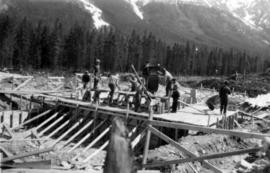
Photograph depicts power house under construction. Temporary camp, service garage, and mountains in background. It is believed that this photograph was taken from top of the plant water tower.
Photograph depicts mill in distance, mountains in background, rocks in foreground. Corresponding note on accompanying photo description page: "Pictures taken June 11th: (1) Erecting timber in mill construction. Tractor in foreground. Looking west."
Photograph depicts men on mill scaffolding, mountains in background. Corresponding note on accompanying photo description page: "Pictures taken June 11th: (4) Mill construction. Looking north."
Corresponding note on accompanying photo description page: "Pictures taken June 11th: (5) Drilling big boulders in truck dump excavation. Looking north."
Photograph depicts mill framework in distance, mountains in background. Corresponding note on accompanying photo description page: "Pictures taken June 28th, 1952: (6) Mill construction. Looking west."
Photograph depicts foundations and framework from interior of building. Corresponding note on accompanying photo description page: "Pictures taken June 28th, 1952: (10) Dryer foundations in mill."
Photograph depicts 9 men working on building speculated to be foundation for diesel engine. (See also items 2000.1.1.2.216 and 2000.1.1.2.217).
Photograph depicts two men working on early stages of building believed to be mill.
Photograph depicts building project and materials in dirt area, mountains in background. Corresponding note on accompanying photo description page: "6: Pouring concrete for second Ruston diesel engine. Mill in background. Looking south." (Note speculated to be incorrect.)
Photograph depicts mill in early stages of construction, trees in foreground, mountains in background. Corresponding note on accompanying photo description page: "11. Erecting wall post on mill foundations. Looking south."
Photograph depicts building in wooded area, dirt road and building supplies in foreground. Corresponding note on accompanying photo description page: "3. Service garage. Tarpaper siding."
Photograph depicts two men standing on concrete foundation poured into wood frame in dirt area. Corresponding note on accompanying photo description page: "2. Crib and gravel foundations for oil tanks."
Photograph depicts two long buildings visible behind small wood structure and steel drums. Rough dirt road in foreground, trees and hillside in background. Corresponding note on accompanying photo description page: "4. Prefabs for staff families. Both 48' x 20'. The 96' x 20' prefab is out of the picture to the right."
Photograph depicts one man in front of garage building under construction. Lumber piles cross mid ground, dirt piles in foreground. Corresponding note on accompanying photo description page: "7. Service garage; hoisting up the roof rafters. Lesell in foreground."
Photograph depicts man operating snow plow in dirt area. Trees and mountain peaks visible in background. Corresponding note on accompanying photo description page: "2. Tractor plowing snow off power house site."
Photograph depicts group of men digging trenches in snow, mountains in background. Corresponding note on accompanying photo description page: "9. Digging Mill foundations."
Photograph depicts wood framework (batter boards?) above lines of gravel. Trees and mountain base in background. Corresponding note on accompanying photo description page: "10. Mill foundation trenches - northwest corner."
Photograph depicts men on long building, one on ladder. Rough dirt road in foreground, trees and hillside in background. Corresponding note on accompanying photo description page: "9. 96 x 20 prefab for staff family quarters. Looking south".
Photograph depicts three men digging at mill site, trees and mountainside in background. Corresponding note on accompanying photo description page: "11. Starting to dig mill foundations. Batter boards in background. Looking northeast."
Photograph depicts a long building speculated to be garage behind large snow pile. Truck semi-visible behind snow, another truck partially captured on right. Snowy road in foreground, mountain peaks in background.
Photograph depicts numerous wood buildings in a line, each with a small porch. The cookery, bunkhouse and office are believed to be among the buildings (see 2000.1.1.2.305). Steel drums lie in front of first building, and another building is semi-visible on right, opposite the others. Snowbank in foreground, trees and mountains in background. Photograph taken facing south. See also items 2000.1.1.2.286 and 2000.1.1.2.301
Handwritten annotation in blue ink on recto of photograph: "Portion of Garage interior". Photograph depicts two men standing in rear of garage interior. One car and Eimco loader can be seen in stalls.
Images contain technical engineering drawings from the Asbestos Mining Corp. Drawings are primarily of plant buildings and mining and milling equipment, but also include drafts of town site and utilities, (extensive images of water and sewer pipes and septic systems). Microfiche slides are 4.6cm x 3.5cm mounted on 8.3 x 18.2 cm paper cards with systematic puncture marks, presumed to be an antiquated form of computer memory. Slides are numbered ranging from 1001 to 1549 and a drawing number ranging from 1006 to 8008, generally in the format “2017/02/02”. Microfiche are dated 1950- 1976, several are dated “OLD”, and several are undated. All microfilm reels are annotated “CASSIAR ENGINEERING DRAWINGS”.
File contains photographs pertaining to the transportation of asbestos fibre.
- These include portraits of Clinton trailer trucks, trucks from the Cassiar Transport Division at Mile 860 on the Alaskan Highway, the assembly of large freight trucks, an unidentified bridge, and ships and buildings at the Cassiar Shipping Facilities at Pier 94 on the Asbestos Warf in North Vancouver, B.C.
- Twenty-three photographs dated 1982 depict asbestos fiber bales on pallets and inside shipping containers, with accompanying annotations commenting on the quality of the packing. Several images show fibre bales broken during shipment. An accompanying note reads: "SMD - please ensure this cannot reoccur.", and a photo caption reads: "pierced bags are resulting as an environmental problem as fibre is beginning to build up in certain containers." One of the photographs depicting the Cassiar Transport Division was used for promotional posters with the following commentary: "The Cassiar Transport Division operates out of Whitehorse, Yukon Territory and is responsible for delivering the asbestos to the White Pass and Yukon Route terminal in Whitehorse. Fuel oil and supplies are backhauled to the mines. By the end of 1967, the fleet will consist of 65 tractor-trailer units, each of which will carry 23 tons of asbestos. The distance from Whitehorse to Cassiar is 357 miles and Clinton is 403 miles. During the past year, the Division's trucks traveled 2,213,534 miles and handled 75,100 tons, and the mileage to 3.5 million miles. This is a year-round operation and convoys arrive at the mine daily in spite of the long difficult haul. The Division currently employs 43 drivers and 35 mechanics and operates its own maintenance and rebuild facilities in Whitehorse. Over the years these men have established and enviable record of safety, cost and performance."
- Additional photographs that have been integrated depict the Asbestos wharf and its condition, 31 slides of wharf, maps of shipping routes, storage, forklifts, shipping trucks, and packaged asbestos.
- Also included in this file are two copies of a "Photo Survey - Cassiar Ton Units - "Amstelveld & Trojoland" on arrival to Brisbane & Sidney - August 1967." This collection of photographs is a part of an assessment of the efficiency of shipping and transport to Australia from Cassiar. Pictures include: loading, forklifts, storage, ripped bags, broken straps, wharfs, trucks, slings. There are accompanied annotations with each of the photos explaining the safety hazards or inefficiency of the situation. This report was found inside a box linked to James Hardie Industries Ltd. This company is not mentioned in the photograph annotations, but could be related to the report since James Hardie Industries Ltd. was a key player in asbestos mining and manufacturing in Australia.
- Collection of photos of roadside spill of Asbestos, depicting a man with shovel cleaning up on 5 June 1985
- Photos from Eternit Societe Anonyme (a European company that Cassiar shipped to) of packaged Asbestos in storage in 1967
- Collection of photos of James Hardie Coy. Pty. Ltd. shipment of asbestos that was not stored or transported effectively. Many photos depict broken bags as a result of inadequate storage and forklift punctures.
- Collection of photos of Cassiar/Stewart Road Proposal. Photos depict tests of the various stages of shipping and transportation process including forklift tests, Marineo Sling tests, stacking tests, durability tests, container loading tests, problems with current units etc. Also included is a marketing drawing if proposed shipping plan - drawn by "Stewart 1977."
- Photos of shipping process of Turners Asbestos Fibres Lmt. Photos depict lowering asbestos pallets onto barge with swing, and storage on barge.
- Collection of photos of a shipment of asbestos, but the bags of fibre are not identified as a Cassiar shipment therefore the location is unknown.
This blueprint depicts the overall layout of the heating and ventilating units to be used for the first and second floor of the recreational centre. Details include the locations of fans, boilers, ducts and exhausts as well as typical heating connector connections and the plumbing layout.
This blueprint depicts the gymnasium lighting layout. Also shown is an isometric view of the air supply unit piping as well as a ventilating unit automatic control diagram. Included are detailed notes regarding system desriptions, its plan and layout as well as directions for the automatic control of the ventilation unit and heating systems.
This blueprint shows the side profile of the proposed tramway at Cassiar. It includes relevant infrastructures and landscape features drawn and marked on the plan such as roads, monocable unloading stations, swamp and beaver ponds as well as streams. The side profile and schematics of the tramway are drawn in parts and includes relevant measurements. Locations of the unloading terminal, jig back towers and jig back loadind stations are included. The overall profile is split into two sections due to elevation changes and lack of drawing surface. Annotation written on the leading edge of the blueprint reads "J.A. Roebling - Proposed Tramway Layout".
Handwritten photo captions below this item and item 2000.1.1.2.2.2: "ELEVATION OF SITE: 6000' " "Two views of completed Crusher Bldg." Man in white hard hat stands beside steel drums in front of garage door on side of crusher building. Mountainside road to crusher in foreground, mountain range in background.
Photograph depicts man driving bulldozer in front of framework for Crusher building, view facing into the mountain. Excavated dirt in foreground.
View facing into mountainside and showing various levels of foundations. Men can be seen working on site. Unidentified machinery and pile of long metal rods in foreground.
Photograph depicts a round bucket attached to the main hook line of a crane (crane not visible in image) suspended over building framework in crusher construction site. Four construction workers stand around the bucket. Two men can be seen on roof of long building in background believed to be the section of the crusher building which housed conveyor B. Dirt road crosses midground.
Photograph depicts one man standing on framework of crusher building and a second man leaning over on a lower level. Lumber and hose in foreground.
Handwritten caption beside this photo reads: "View of Crusher Base." Wood and metal framework throughout, lumber and scaffolding in foreground. View facing into mountainside.
View showing various levels of foundations. Men can be seen working on site. Vertically protruding planks from framework in foreground. A long building believed to be housing conveyor "B" can be seen in background, as well as the tree-covered valley.
Photograph depicts four construction workers in front of tall wood structure extending to top level of construction area. Building material and supplies cover the ground: lumber, saw horses etc. Barricades against loose rock enclose area in midground (see item 2000.1.1.2.352). Plastic-covered pile sits at top level in background.
Photograph depicts different levels of crusher foundations built into mountainside. Dirt piles and unidentified machinery in foreground, power lines and mountain range in background.
Handwritten caption beside this photo reads: "Lowering Crusher Base into place." Square crusher base in foreground is being lowered by a traveler crane on wheels. Two construction workers stand watching on left. Crane stands against mountainside in background.
Handwritten caption beside this photo reads: "Moving the sides of Bin into place. Weight nine tons". Two construction workers on right of a large steel bin side. Steel framework and sheeting in background.
Handwritten annotation on recto of photograph: "RETAINING RIBS JUNE 29/64". Photograph depicts construction workers on and near wooden framework structure extending from base of crusher building. Crane in background against mountainside. Miscellaneous construction equipment and materials throughout.
Photograph depicts large square model of the new mill building that was built at the Cassiar plant site in 1970. Model is displayed outdoors on a platform that stands on four saw horses. Machinery modeled inside the structure is colour-coded. Plant buildings and mountains in background.
Photograph depicts extreme close up of colour-coded machinery modeled inside large square model of the new mill building that was built at the Cassiar plant site in 1970.
Photograph depicts large square model of the new mill building that was built at the Cassiar plant site in 1970. Model is displayed on platform draped with green material. Machinery modeled inside the structure is colour-coded.
File contains photographs of a report completed in 1980 depicting the ambulance garage, as well as the interior and exterior of the hospital building in Cassiar, B.C. Each room is captured, as well as medical equipment such as the X-ray, audiometer, lung function apparatus, and autoclave. A doctor, two nurses, and several patients are shown. Accompanying report contains a description of the medical facilities in Cassiar including a detailed budget, description of staffing and utility requirements, and a floor plan of the facilities.
In addition there are two albums of Cassiar Hospital and Pharmacy Staff engaging in social functions. These photographs appear to be informal and depict staff parties, people at work and some of the patients, including their thank you notes to the Cassiar Hospital staff.
File contains images depicting room by room view of a house in Cassiar identified as house 288. Handwritten annotation on verso of photographs: "288 June-9-1992". Photographs originally found in file labeled "TOWN ADMINISTRATION Small Business 1981"; it is likely that these images form part of the process documentation for a small business license.
Photograph depicts the Cassiar townsite behind shadow in foreground. Plantsite can be seen including the mill, dry rock storage building, tailings pile, and many other buildings. Mountains in background. Handwritten annotation on recto: "<- 13 1/2" ->". (This photograph was made into a promotional poster.)
Photograph depicts the North peak of McDame mountain after extensive strip mining, South peak unmined in background. Old mine garage visible on right of West peak in foreground. Crusher plant partially visible on far right. Photograph believed to have been taken just prior to the development of the pit mine between the North and West peak.
Photograph depicts the Cassiar valley: town on left, plant on right, mine valley in background. Photograph was taken from above, facing north east.
Photograph depicts the Cassiar plantsite behind tailings pile in foreground. Mine road runs north though valley bellow mine, strip mining barely visible in background. Photograph was taken from above, facing north.
Photograph depicts the Cassiar valley: town in left foreground, plant and tailings pile in midground, mountains in background. Photograph was taken from the air, portion of plane visible in top left of image.
Photograph depicts the Cassiar valley: town on left, plant and tailings pile on right, mountains in background. Mine road can be seen from plant to mine valley in top left of image.