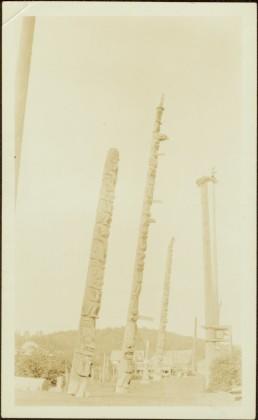
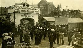
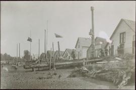
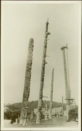
Shoreline perspective of an unidentified coastal village situated on B.C.’s north coast. European style houses run parallel to a rocky shore. Seven men and one child stand within this frame and totem poles and a mortuary pole are also visible along the shoreline.
Chief’s ceremonial Chilkat robe hung for portrait; associated headress is attached to wall above it. Woven headress features the inset face of a carved wooden bird.
Handwritten annotation in pen on verso: “Chief’s Dancing Robe surmounted by Dancing Headress for page 8.” Verso also has additional handwritten annotations which have been crossed out. Stamped photographers mark on recto: “Werner & Son; 39 Grafton St. Dublin.”
Photograph features an arranged collection of Chief’s ceremonial regalia: Chikat robe and Amalayt (headdress), two carved wooden rattles and two leggings.
Handwritten annotation in pen on recto reads: “Qush ahlied (?) or Chilcat [sic] Robe worn by Chiefs when entertaining. Also 'Ahm Ahlied'(?) or Head Ornament Indian Coronet and leggings." Verso also has additional handwritten annotations which have been crossed out.
Photograph depicts a mortuary pole situated against a snowy landscape.
Handwritten annotation on verso reads: “Chapter XVIII, Nom. 1 Chief Gwaksho’s totem pole. The Great Hunter.”
Totem pole stands alone against a mountainous background.
Petroglyphs featuring coppers painting onto a rock face next to a lake.
Handwritten annotation in pencil on verso reads: “As seen from the R.R. track. By Harlan I. Smith. 4 poles E of 92 mile or about 1 ½ meter E. of Tyce, B.C., Red Pictograph, Note: head above and to the right at the left of log top in shadow of cedar.” Stamped annotation on verso reads: “Department of Mines Geological Survey Photographic Division, January 21 1926” – in pen above this stamped date is written “7-10-1925”.
Carvings visible on a moss covered rocky outcrop. Handwritten annotation in pencil on verso reads: “Rock carvings. Copper Mountain, Al”.
Photograph of a marching band performing down a wooden road. Spectators can be seen in the foreground and various businesses are in the background. Annotation on recto reads: "Prince Rupert BC."
Photograph of a large crowd in formal wear gathered on a slope. Some spectators can be seen perched atop extremely high poles. Annotation on recto reads: "The Crowd at Prince Rupert's Dominion Day Celebration 1909. Allen Photo 1-7-09."
Photograph of a young girl believed to be Katy Collison seated for a formal portrait on a wheeled chair. Handwritten annotation in pen on recto reads: "With love from 'Mama'[?] 1907." Handwritten address on verso reads: "Miss West[?] Metlakatla British Columbia N.W. America." Two half penny stamps affixed on verso and partially obscured by two postmarks which read: "Folkstone 1.15 PM SP 19 07."
Photograph of large crowd spanning the frame of the photograph. A large marching band is visible along the edges of a small clearing in the centre. Annotation on recto reads: "May 24th Prince Rupert BC."
Large crowd gathered on the street in downtown Prince Rupert. Decorations are hung around and town, and a lavishly decorated arch in the background reads "Come One Let 'Em All Come Come All. Welcome to Prince Rupert."
Large crowd gathered on the street in downtown Prince Rupert around a lavishly decorated arch which reads "Come One Let 'Em All Come Come All. Welcome to Prince Rupert." Annotation on recto reads: "Arch Prince Rupert, BC. Dominion Day Celebration 1909. Allen Photo."
Photograph of Centre Street in Prince Rupert on Dominion Day. The Union Bank of Canada is located on the left side of the street, and a decorative arch can be seen in the background. Annotation on recto reads: "Centre Sr. Prince Rupert Dominion Day Celebrations 1909 Allen Photo July 09."
Photograph of a small marching band parading down Second Avenue in Prince Rupert. A large crowd is gathered. Annotation on recto reads: "Photo by MacRae Bros Prince Rupert BC 2nd Ave Prince Rupert BC."
Photograph of several floats parading down Second Avenue in Prince Rupert. A large crowd is gathered. Annotation on recto reads: "Photo by MacRae Bros Prince Rupert BC Prince Rupert B."
Photograph of a stone monument atop a small hill on a forested shoreline. Annotation on recto reads: "Alexander Mackenzie Monument, Dean Channel, Near Ocean Falls, BC."
Photograph depicts two connected buildings; the building on the left is possibly the theatre, other building with sign that reads: "The Nechaco (sic?) General Stores." Boardwalk with people and unpaved street in foreground.
Large crowd gathered on the street in downtown Prince Rupert around a lavishly decorated arch which reads "Come One Let 'Em All Come Come All. Welcome to Prince Rupert." Annotation on recto reads: "Arch Prince Rupert, BC. Dominion Day Celebration 1909. Allen Photo."
Photograph of an illustration of an elderly man peering over a photograph of Prince Rupert, BC with a magnifying glass. Beaded leather tassels are affixed to the edges of the illustration. Printed annotation on recto reads: "Taken in 1911. And Today The Eyes of the World are on Prince Rupert. Craig N of Prince Rupert."
Image depicts a snow sculpture of a bear, possibly during the Winter City Conference, in Prince George, B.C. Taken at the Prince George Civic Center. Map coordinates 53°54'45.6"N 122°44'59.6"W
Image depicts two snow sculptures near a wooden bridge on an ice rink, possibly during the Winter City Conference, in Prince George, B.C. Taken at the Prince George Civic Center. Map coordinates 53°54'45.6"N 122°44'59.6"W
Image depicts a snow sculpted fire place and couch on a skating rink, possibly during the Winter City Conference, in Prince George, B.C. Taken at the Prince George Civic Center. Map coordinates 53°54'45.6"N 122°44'59.6"W
Image depicts a snow sculpture of the Mr. P.G. lounging on a couch, possibly during the Winter City Conference, in Prince George, B.C. Taken at the Prince George Civic Center. Map coordinates 53°54'45.6"N 122°44'59.6"W
Image depicts a snow sculpture of a man with a shovel, possibly during the Winter City Conference, in Prince George, B.C. Taken at the Prince George Civic Center. Map coordinates 53°54'45.6"N 122°44'59.6"W
Image depicts Studio 2880 Arts Complex in Prince George, B.C. Map coordinates 53°54'36.9"N 122°46'30.3"W
Image depicts the Two Rivers Art Gallery in Prince George, B.C.
Image depicts the Prince George Public Library.
Image depicts the Prince George Public Library from 7th Ave.
Image depicts the Fort George Regional Museum in Prince George, B.C.
Image depicts the Lheidli T'enneh Burial Grounds in Fort George Park.
Image depicts the Two Rivers Art Gallery in Prince George, B.C.
Image depicts a building which is a part of the Studio 2880 Arts Complex on 15th Avenue in Prince George, B.C.
Image depicts the Wells Museum in Wells, B.C.
Image depicts the historical village of 'Ksan near Hazelton, B.C.
Image depicts a totem pole in the historical village of 'Ksan near Hazelton, B.C.
Image depicts a group of people in the historical village of 'Ksan near Hazelton, B.C.
Image depicts two totem poles in Skeena Crossing, B.C.
Image depicts numerous totem poles in Kispiox, B.C.
Image depicts a large gathering of people in the interior of a First Nations' longhouse located in the historical village of 'Ksan in Hazelton, B.C.
Image depicts an old, partially burnt totem pole in Kispiox, B.C.
Image depicts the 'Ksan historical village in Hazelton, B.C.
Image depicts the public library in Hazelton, B.C.