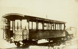
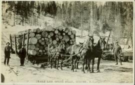
Photograph of a team of horses pulling a large load of logs. Several men are posed around the sleigh. Printed annotation on recto reads: "Eagle Lake Spruce Mills, Giscome, B.C." Handwritten annotation on verso reads: "4/ This is them after loading. You will observes that this four horse team has two loads, each sleigh has 14 ft banks[??] and is loaded with about 5 thousand feet of logs. In one camp they have a cattepillar[sic] tractor that takes as high as eight sleighs from the bush to the loading [??]. Will try and get you a picture for you. Elizabeth has has very poor health since last March. May have to change residences befor[sic] long very poor doctor here."
Photograph of man on the back of a passenger car attached to a steam engine. Printed annotation on recto is obscured by emulsion damage and reads: "[illegible] Atlin, B.C."
Stern wheeler in river. Printed annotation on recto reads: “Steamer B.X. Monarch of New B.C. Soda Creek, Quesnel and Fort George”
Stern wheeler in river. Printed annotation on recto reads: “Operator 1913, Prince George, B.C. Canada” Handwritten annotation in pencil on verso reads: “Operator 1913”
Stern wheeler in river. Handwritten annotation in pencil on verso reads: “Prince George to Tete Jaune” Hand written message in ink on verso is addressed to “Mademoiselle Elisabeth Joliet, Terrguy – Les Dijore Cote a Or France”
Subseries contains material relating to the administrative functions of the Grand Trunk Railway, including financial records.
Subseries contains used and unused railway and financial forms.
Subseries consists of correspondence between Grand Trunk Railway and other railway systems, particularly the Wabash Railroad Company.
Subseries contains ephemera related to the Grand Trunk Railway.
Postcard depicts Cathedral Mountain on the Canadian Pacific Railway.
Slightly oblique front view of railway cars on a track. Buildings and hills can be seen in the background. Printed annotation on recto reads: "Railway Station and Park Area, McBride, B.C."
Photograph of a large crowd gathered at the McBride train station. Printed annotation on recto reads: "'Rocky Mountain Rangers Band, McBride, B.C.'"
Subseries contains maps and plans depicting railway sites in British Columbia and the Yukon.
Photograph of a train traveling through Prince Rupert. Several people are gathered on the dock and around various buildings. Two small vessels are docked in the harbour. Annotation on recto reads: "Prince Rupert, Waterfront. Allen Photo May '4."
Street scene depicting people, boardwalks, horse & wagons, and delivery truck. Printed annotation on recto reads: “3rd Ave. Prince Rupert. B.C.”
Typed annotation in red ink on recto reads: “3rd Ave. Prince Rupert. B.C.” People, boardwalks, horse & wagons and store signs are visible. Rubble and unknown material lies on ground between boardwalks. Typed annotation in red ink on recto reads: “3rd Ave. Prince Rupert. B.C.”
This collection consists of photographs and "real photo" postcards that depict the construction and operation of the Pacific Great Eastern Railway line, communities nearby the railway line, and regional geography of areas adjacent to the PGE line.
Mountains stand behind water in background. Handwritten annotation on negative: "looking [over?] Kopoka".
Image is one of 65 photos documenting a survey of the Canada-Alaska Boundary, Taku River area, May 23 to Oct. 15, 1906.
This particular photo is one of 13 found in original enclosure with the following handwritten annotation: "Kopoka River - river scenes Aug 29 to Oct. 9 [19]06". See also items 2006.20.3.1 - 2006.20.3.13.
Photograph depicts two unidentified men on small boat with sail, opposite shore in background. Handwritten annotation on negative: "Prospectors on Taku Sailing".
Image is one of 65 photos documenting a survey of the Canada-Alaska Boundary, Taku River area, May 23 to Oct. 15, 1906.
This particular photo is one of 13 found in original enclosure with the following handwritten annotation: "Kopoka River - river scenes Aug 29 to Oct. 9 [19]06". See also items 2006.20.3.1 - 2006.20.3.13.
Photograph depicts three unidentified men loading canoe on river shore.
Image is one of 65 photos documenting a survey of the Canada-Alaska Boundary, Taku River area, May 23 to Oct. 15, 1906.
This particular photo is one of 8 found in original enclosure with the following handwritten annotation: "From main camp up Kopoka River. Scenes with persons in." See also items 2006.20.3.14 - 2006.20.3.21.
Image is one of 65 photos documenting a survey of the Canada-Alaska Boundary, Taku River area, May 23 to Oct. 15, 1906.
This particular photo is one of 13 found in original enclosure with the following handwritten annotation: "SOME OTHERS." See also items 2006.20.3.22 - 2006.20.3.34.
Pile driver situated on Prince Rupert shoreline. Tents and wooden buildings visible on rocky background. Printed annotations on recto of photograph read: "First pile driven at Prince Rupert BC. June 8 '06."
Postcard depicts the Lake Louise CPR depot.
Postcard depicts Field station in the Rockies. Man standing on the left with a bowler hat was Chris McGregor, a professional (mining?) engineer. Earliest frank seen for the postcard was in July 1906.
Postcard depicts Cathedral Mountain.
Postcard taken on Field Hill, along the CPR line.
Postcard depicts a spiral tunnel near Field, in which trains make a complete turn around the Canadian Rockies. One of two spiral tunnels, and the first of this system introduced on the continent. The greatest pieced of tunnelling ever attempted in Canada. Cost 1,5000,000. Time of work: 20 months. 75 car-loads of dynamite used.
Postcard depicts a train exiting a tunnel along the CPR line.
Photograph depicts two unknown men walking on rocky shore with canoe over their heads. Water and forest in background. Handwritten annotation visible on negative: "[?] portaging canoe".
Image is one of 65 photos documenting a survey of the Canada-Alaska Boundary, Taku River area, May 23 to Oct. 15, 1906.
This particular photo is one of 8 found in original enclosure with the following handwritten annotation: "From main camp up Kopoka River. Scenes with persons in." See also items 2006.20.3.14 - 2006.20.3.21.
Photograph depicts two men paddling in canoe, shore in background. Handwritten annotation visible on negative reads: "Stughes & B_ Lake behind Main Camp Taku River".
Image is one of 65 photos documenting a survey of the Canada-Alaska Boundary, Taku River area, May 23 to Oct. 15, 1906.
This particular photo is one of 13 found in original enclosure with the following handwritten annotation: "SOME OTHERS." See also items 2006.20.3.22 - 2006.20.3.34.
Photograph depicts two men climbing up snowy area with walking poles and other gear. Handwritten annotation visible on negative: "Nellis & Gilroy Snow [?] - No.3."
Image is one of 65 photos documenting a survey of the Canada-Alaska Boundary, Taku River area, May 23 to Oct. 15, 1906.
This particular photo is one of 13 found in original enclosure with the following handwritten annotation: "SOME OTHERS." See also items 2006.20.3.22 - 2006.20.3.33.
Postcard depicts the Great Divide between Alberta and British Columbia, along the CPR line.
Postcard depicts the passage through the shoulder of Mt. Stephen.
Postcard depicts Mt. Stephen and Field, BC
Postcard depicts Kicking Horse Canyon.
Postcard depicts Mt. Stephen and Kicking Horse River.
Postcard depicts the Kicking Horse Canyon near Yoho National Park.
Photograph depicts unknown man standing in water while pulling loaded canoe by rope. Rocky shore in foreground, mountains in background. Handwritten annotation visible on negative: "[?] hauling canoe. Big [?], Kopoka".
Image is one of 65 photos documenting a survey of the Canada-Alaska Boundary, Taku River area, May 23 to Oct. 15, 1906.
This particular photo is one of 8 found in original enclosure with the following handwritten annotation: "From main camp up Kopoka River. Scenes with persons in." See also items 2006.20.3.14 - 2006.20.3.21.
Photograph depicts three unknown men standing in water while pulling loaded canoe by rope. Rocky shore and hills in background. Illegible handwritten annotation visible on negative: "...[K. River]?" (Kopoka?)
Image is one of 65 photos documenting a survey of the Canada-Alaska Boundary, Taku River area, May 23 to Oct. 15, 1906.
This particular photo is one of 8 found in original enclosure with the following handwritten annotation: "From main camp up Kopoka River. Scenes with persons in." See also items 2006.20.3.14 - 2006.20.3.20.
Photograph depicts unknown men standing with walking sticks, carrying large bundles on their backs. Water and opposite shore in background, mountains visible in distance. Handwritten annotation visible on negative: "Billy [Gilroy?] & [?] packed for [?]".
Image is one of 65 photos documenting a survey of the Canada-Alaska Boundary, Taku River area, May 23 to Oct. 15, 1906.
This particular photo is one of 13 found in original enclosure with the following handwritten annotation: "SOME OTHERS." See also items 2006.20.3.22 - 2006.20.3.34.
Photograph depicts two men standing on mountain with walking sticks, carrying bundles on their backs. Valley and mountains visible in background below. Handwritten annotation visible on negative: "[?] Climbing [?] Sta - K. River" (Kopoka?).
Image is one of 65 photos documenting a survey of the Canada-Alaska Boundary, Taku River area, May 23 to Oct. 15, 1906. This particular photo is one of 7 found in original enclosure with the following handwritten annotation: "Around River Taku and main camp on same." See also items 2006.20.3.35 - 2006.20.3.41.
Postcard depicts Mt. Stephen, Field, BC
Postcard depicts Kicking Horse Canyon near Mt. Field.
Item is a print of a photograph of a person poling a dugout canoe between 1906 and 1908.
Photograph depicts unknown man in canoe, opposite shore and hills in background.
Image is one of 65 photos documenting a survey of the Canada-Alaska Boundary, Taku River area, May 23 to Oct. 15, 1906.
This particular photo is one of 8 found in original enclosure with the following handwritten annotation: "From main camp up Kopoka River. Scenes with persons in." See also items 2006.20.3.14 - 2006.20.3.21.
Postcard depicts the Canadian Pacific Railway line where the Great Divide between BC and Alberta.
Postcard depicts Castle Mountain found along the Canadian Pacific Railway line.
Postcard depicts one of the upper sprial tunnels in Field, BC
Postcard depicts a train entering a lower spiral tunnel. Mount Stephen visible.
Postcard depicts a lower spiral tunnel along the CPR line near Field, BC