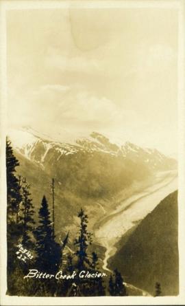
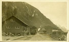
Affichage de 3593 résultats

Archival description
3593 résultats avec objets numériques Afficher les résultats avec des objets numériques
Bitter Creek Glacier
2011.13.55 · Pièce · [ca. 1910-1930]
Fait partie de Parker photograph collection

Wide angle perspective of the Bitter Creek glacier, with trees visible in the foreground. Printed annotation on recto reads: "Hughes #22 Bitter Creek Glacier."

2009.7.1.004 · Pièce · [ca. 1915]
Fait partie de Archdeacon W. H. Collison fonds

Photograph depicts the sons and daughters of Marion and Archdeacon W.H. Collison, and one unidentified man. Buildings can be seen on shore in background.

Handwritten annotation on verso reads: "Collison family at camp (Portland Canal) Max, ?, Henry, Elsie, Arthur, Alice, Herbert".

2009.7.1.016 · Pièce · [ca. 1910]
Fait partie de Archdeacon W. H. Collison fonds

Photograph depicts Marion and William Henry Collison standing on left with shovel, Bertha Collison on right, and young Muriel and Katherine Collison in centre with shovel (eldest daughters of W.E. Collison). Wood buildings cross midground, trees and hills visible in background.

Handwritten annotation on verso reads: "Garden at Kincolith / Grandad, Grannie / Mimi, Katie / Mother".

2009.7.1.018 · Pièce · [ca. 1910 - ca. 1930]
Fait partie de Archdeacon W. H. Collison fonds

Rev. William Edwin Collison stands waist deep in water, with axe resting on shoulder (oldest son of Archdeacon W.H. Collison). Trees and hill on opposite shore visible in background.

Handwritten annotation on verso reads: "Dad at Kincolith".

Totem Pole in park at Prince Rupert, BC
2009.7.1.049 · Pièce · [ca. 1930?]
Fait partie de Archdeacon W. H. Collison fonds

Photograph depicts a totem pole standing on what appears to be a large wooden deck or boardwalk, view of the city in background.

Handwritten annotation on verso reads: "Totem pole in park in Prince Rupert".

2009.7.1.055 · Pièce · [between 1903 and 1914]
Fait partie de Archdeacon W. H. Collison fonds

Photograph depicts large buildings on shore. Three unidentified individuals can be seen walking on dock in foreground.

Printed on image: "METLAKATLA B.C. / McRAE BROS"; handwritten annotation on verso reads: "A section of Metlakahtla, showing Church & Schoolhouse." See also item 2009.7.1.58 for similar image also featuring the new church building at Metlakatla, B.C.

First Nations jail at Metlakatla, BC
2009.7.1.061 · Pièce · [ca. 1873 - ca. 1920]
Fait partie de Archdeacon W. H. Collison fonds

Photograph depicts a man and woman standing on steps to a round tower in fenced area. Roofs of other buildings can be seen below on right; water and shore visible in background.

Printed on image: "Indian Jail, Metlatkla".

2009.7.1.140 · Pièce · [ca. 1925?]
Fait partie de Archdeacon W. H. Collison fonds

Group of six men sit and stand on small boat close to shore. Rev. W.E. Collison stands on far right (son of Marion and Archdeacon W.H. Collison).

Handwritten annotation on verso reads: "Dr. Macdonald Med officer (Kincolith) / Dr. [McQuarrie?] Med officer Victoria / Steven Clayton Native boat owner / Capt. Bary - Insp. of Indian Schools / W.E. Collison Indian agent. / Inspection trip to villages of upper Nass River".

'Place of Echoes' at Kincolith, BC
2009.7.1.150 · Pièce · [ca. 1878 - ca. 1915]
Fait partie de Archdeacon W. H. Collison fonds

Photograph features a steep cliff across water, rocky shore in foreground.

Handwritten annotation on verso reads: "Up the 'Big Creek' at Kincolith B.C. Rock face called 'the place of echoes' by the Indian people."

2009.7.1.160 · Pièce · [ca. 1880 - ca. 1915]
Fait partie de Archdeacon W. H. Collison fonds

Photograph features rapids in foreground, trees and rocks in background.

Handwritten annotation on verso reads: "A waterfall on American side of the Canal. Chapt. XXVI Waterfall on Alaskan side of Portland Inlet."

Shoreline Petroglyphs
2009.7.1.174 · Pièce · [ca. 1925]
Fait partie de Archdeacon W. H. Collison fonds

Petroglyphs featuring coppers painting onto a rock face next to a lake.

Handwritten annotation in pencil on verso reads: “As seen from the R.R. track. By Harlan I. Smith. 4 poles E of 92 mile or about 1 ½ meter E. of Tyce, B.C., Red Pictograph, Note: head above and to the right at the left of log top in shadow of cedar.” Stamped annotation on verso reads: “Department of Mines Geological Survey Photographic Division, January 21 1926” – in pen above this stamped date is written “7-10-1925”.

Tabor Mountain
2012.13.1.3.028 · Pièce · Oct. 1975
Fait partie de J. Kent Sedgwick fonds

Image depicts Tabor Mountain from the airport in Prince George, B.C.

View from Gunn Point
2012.13.1.3.058 · Pièce · Nov. 1979
Fait partie de J. Kent Sedgwick fonds

Image depicts a view of Prince George from Gunn Point in the L.C. Gunn Park looking north. Map coordinates 53°54'26.2"N 122°43'35.8"W.

View from Gunn Point
2012.13.1.3.062 · Pièce · Nov. 1979
Fait partie de J. Kent Sedgwick fonds

Image depicts a view of Prince George from Gunn Point in the L.C. Gunn Park looking north. Map coordinates 53°54'26.2"N 122°43'35.8"W.

View from Gunn Point
2012.13.1.3.063 · Pièce · Nov. 1979
Fait partie de J. Kent Sedgwick fonds

Image depicts a view of Prince George from Gunn Point in the L.C. Gunn Park looking north. Map coordinates 53°54'26.2"N 122°43'35.8"W.

View from Gunn Point
2012.13.1.3.066 · Pièce · Nov. 1979
Fait partie de J. Kent Sedgwick fonds

Image depicts a view of Prince George from Gunn Point in the L.C. Gunn Park looking north. Map coordinates 53°54'26.2"N 122°43'35.8"W.

View from Gunn Point
2012.13.1.3.067 · Pièce · Nov. 1979
Fait partie de J. Kent Sedgwick fonds

Image depicts a view of Prince George from Gunn Point in the L.C. Gunn Park looking north. Map coordinates 53°54'26.2"N 122°43'35.8"W.

Tabor Mountain
2012.13.1.3.068 · Pièce · Nov. 1979
Fait partie de J. Kent Sedgwick fonds

Image depicts a view of Prince George, from Gunn Point in the L.C. Gunn Park.

Nechako Cutbanks Trail
2012.13.1.3.091 · Pièce · 12 Oct. 1989
Fait partie de J. Kent Sedgwick fonds

Image depicts the cutbanks on the other side of the Nechako, taken from the nature trail at Island Cache. Map coordinates 53°55'34.6"N 122°45'52.4"W

Blackburn Schools
2012.13.1.3.128 · Pièce · 13 Aug. 1989
Fait partie de J. Kent Sedgwick fonds

Image depicts a view of Blackburn Schools, possibly taken from Tabor Mountain.

Prince George
2012.13.1.3.134 · Pièce · 12 Oct. 1989
Fait partie de J. Kent Sedgwick fonds

Image depicts Prince George, possibly with the Northwood Pulpmill in the background.

View of Downtown Prince George
2012.13.1.3.157 · Pièce · Nov. 2000
Fait partie de J. Kent Sedgwick fonds

Image depicts downtown Prince George taken from across the Nechako River looking south. Map coordinates 53°56'00.0"N 122°44'29.7"W

Prince George Sawmill
2012.13.1.3.159 · Pièce · Nov. 2000
Fait partie de J. Kent Sedgwick fonds

Image depicts Prince George Sawmill taken from across the Nechako River looking southwest. Map coordinates 53°56'00.0"N 122°44'29.7"W

Prince George Residential Area
2012.13.1.3.168 · Pièce · Mar. 2003
Fait partie de J. Kent Sedgwick fonds

Image depicts an aerial view of a Prince George residential section between Highway 97, Carney Street and 10th Ave looking north. Map coordinates 53°54'54.0"N 122°46'00.4"W

Cariboo Road
2012.13.1.6.031 · Pièce · June 1974
Fait partie de J. Kent Sedgwick fonds

Image depicts the Cariboo Road at Hat Creek Ranch, near Highway 99 on the way to Lillooet.

McLeod Lake
2012.13.1.6.091 · Pièce · Aug. 1979
Fait partie de J. Kent Sedgwick fonds

Image depicts McLeod Lake and several buildings along the shore.

Metlakatla
2012.13.1.6.095 · Pièce · Aug. 1979
Fait partie de J. Kent Sedgwick fonds

Image depicts buildings in the village community of Metlakatla, B.C.