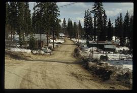
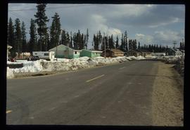
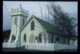
Image depicts a street in Giscome. The store was previously located on the left. The church is in the background. Map coordinates 54°04'18.5"N 122°21'57.7"W
Image depicts a snow-covered road at an uncertain location.
Image depicts Prince George Sawmill taken from across the Nechako River looking southwest. Map coordinates 53°56'00.0"N 122°44'29.7"W
Image depicts some buildings along a dirt road, possibly near Bear Lake, B.C.
Image depicts an uncertain street in Prince George, B.C.
Image depicts the Lheidli T'enneh Burial Grounds in Fort George Park.
Image depicts 1480 Birch Street in Prince George, B.C.
Image depicts some of the 1445 Elm Street and 1425 Elm Street houses in the Millar Addition neighbourhood of Prince George, B.C.
Image depicts 1690 Dogwood Street, on the corner of 17th Ave and Dogwood St. in Prince George, B.C. Also depicts a portion of 1670 Dogwood Street at left.
Image depicts a view of the Millar Addition suburb from Connaught Hill in Prince George, B.C.
Image depicts 1532 Fir Street in Prince George, B.C.
Image depicts 1598 Fir Street in Prince George, B.C.
Image depicts 1488 Gorse Street in Prince George, B.C.
Image depicts 1386 Ingledew Street in Prince George, B.C.
Image depicts 1354 Ingledew Street in Prince George, B.C.
Photograph taken looking north, with a spur in the foreground. It was used by ore mixed freight daily. It was believed that at the bottom of the grade was a junction with a GNR branch that ran from the US border south of Creston to Kootenay Lake (built in 1904, then was hardly used, finally ceased in 1910).
Image depicts downtown Prince George taken from across the Nechako River looking south. Map coordinates 53°56'00.0"N 122°44'29.7"W
Image depicts Prince George Sawmill taken from across the Nechako River looking southwest. Map coordinates 53°56'00.0"N 122°44'29.7"W
Image depicts some houses in Bear Lake, B.C.
Image depicts some houses most likely in Bear Lake, B.C.
Image depicts a shack, possibly near Bear Lake, B.C.
Image depicts Prince George with numerous trees obscuring most of the view.
Image depicts Prince George.
Image depicts 1598 Fir Street in Prince George, B.C.
Image depicts 1465 Elm Street, 1445 Elm Street, and 1425 Elm Street in the Millar Addition neighbourhood of Prince George, B.C.
Image depicts 1425 Taylor Drive in Prince George, B.C.
Image depicts 1650 Dogwood Street and 1670 Dogwood Street in the Millar Addition neighbourhood in Prince George, B.C.
Image depicts a property given to the Veterans of the Second World War, located on the corner of 15th Avenue and Elm Street in Prince George, B.C.
Image depicts 1510 Fir Street in Prince George, B.C.
Image depicts 1590 Fir Street in Prince George, B.C.
Image depicts 135 Patricia Boulevard in Prince George, B.C.
Image depicts the Giscome mill site in Giscome, B.C. The bunkhouse is in the background on the left and the school is in the foreground on the right. Map coordinates 54°04'04.8"N 122°22'04.7"W
Image depicts the Giscome mill site in Giscome, B.C. The bunkhouse is the large building with many windows. A train and railroad tracks are in the foreground. Map coordinates 54°04'17.6"N 122°22'06.1"W
Image depicts employee houses on mill site in Giscome, B.C. Tug boats are in the foreground on the right. Map coordinates 54°04'23.4"N 122°22'16.9"W
Image depicts a street of houses in Giscome, B.C. Map coordinates 54°04'20.9"N 122°21'53.1"W
Image depicts numerous old buildings on a main street in Atlin, B.C.
Image depicts a pyramid shaped house, possibly located in Atlin, B.C.
Image depicts the grave of John Wolters in the Atlin Cemetery. It reads: "Born in Kent, England, Jan 16 1857. Died Sept. 21 1905."
Image depicts a river in the Miles Canyon near Whitehorse Y.T. The Robert Lowe Bridge, built in 1922, can be seen over the canyon.
Image depicts a lake and a cabin at an uncertain location.
Image depicts a sign, labelled "The White Pass Snow Fleet," which details the history of the fleet; it is located in Skagway, Alaska.
Image depicts two merging railway tracks, and what appears to be a frozen river, somewhere near the summit of a mountain.
Image depicts a grave somewhere along the White Pass railway.
Image depicts the Northwood Bridge in Prince George, B.C.
Image depicts the Prince George Sawmill from the Northwood Bridge.
Image depicts Francois Lake.
Image depicts a section of land on the east end of Francois Lake. The lake is visible in the distance.
Image depicts the office at the Northwood Upper Fraser Saw Mill and a sign which reads "Have a safe, quality day." Map coordinates 54.117916, -121.943351
Image depicts an Anglican Church at the Atlin Museum.