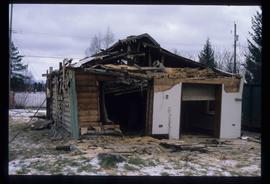
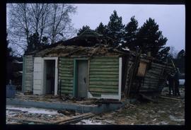
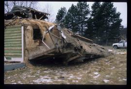
Affichage de 1595 résultats

Archival description
1595 résultats avec objets numériques Afficher les résultats avec des objets numériques
Giscome Dairy Farm
2012.13.1.87.083 · Pièce · [between 1975 and 1995]
Fait partie de J. Kent Sedgwick fonds

Image depicts a large, old and collapsing barn, as well as a nearby house of the dairy farm in Giscome, B.C. Map coordinates 54°03'53.3"N 122°21'22.6"W

2012.13.1.87.095 · Pièce · [between 1980 and 2000]
Fait partie de J. Kent Sedgwick fonds

Image depicts the Giscome mill foreman's house on the hill, with Eaglet Lake in the background and numerous piles of logs in the foreground. Map coordinates 54°04'28.0"N 122°22'05.8"W

Buildings in Newlands, BC
2012.13.1.87.101 · Pièce · [between 1975 and 1995]
Fait partie de J. Kent Sedgwick fonds

Image depicts several old buildings in a field, one of which has a caved-in roof, in Newlands, B.C. Map coordinates 54°06'28.2"N 122°12'01.0"W

A Kitchen
2012.13.1.87.110 · Pièce · [between 1970 and 1990]
Fait partie de J. Kent Sedgwick fonds

Image depicts the interior of a kitchen at an uncertain location.

In Memory Of - Grave-Marker
2012.13.1.87.150 · Pièce · [between 1975 and 1995]
Fait partie de J. Kent Sedgwick fonds

Image depicts a grave-marker with several names, it reads: "In Memory of Edith Golder, Winnifred Golder, Baby Pelton, Mrs. Nazarek, Baby Nazarek, Baby Wazylyk 1915 - 1929." It is located in the Willow River Cemetery.

Giscome Sawmill
2012.13.1.87.167 · Pièce · [between 1975 and 1995]
Fait partie de J. Kent Sedgwick fonds

Image depicts the mill site at Giscome, B.C. Map coordinates 54°04'19.7"N 122°22'04.7"W

Giscome Sawmill
2012.13.1.87.171 · Pièce · [between 1975 and 1995]
Fait partie de J. Kent Sedgwick fonds

Image depicts the mill site at Giscome, B.C. A sign in the foreground reads "Maynard's Industrial Auctioneers." Map coordinates 54°04'19.7"N 122°22'04.7"W

Giscome Sawmill Food Stand
2012.13.1.87.172 · Pièce · [between 1975 and 1995]
Fait partie de J. Kent Sedgwick fonds

Image depicts a food stand at the mill site at Giscome, B.C. Map coordinates 54°04'19.7"N 122°22'04.7"W

Giscome Street Scene
2012.13.1.87.173 · Pièce · [between 1975 and 1995]
Fait partie de J. Kent Sedgwick fonds

Image depicts a street in Giscome B.C. The Giscome Store is located on the left side of the image with the church in the background. Map coordinates 54°04'18.5"N 122°21'57.7"W

Giscome
2012.13.1.87.175 · Pièce · [between 1975 and 1995]
Fait partie de J. Kent Sedgwick fonds

Image depicts the Giscome, B.C. town site with the Giscome railway station and the Giscome store in the center surrounded by vehicles. Map coordinates 54°04'18.5"N 122°21'57.7"W

Penny - Hiking Trail Signs
2012.13.1.88.49 · Pièce · 2004
Fait partie de J. Kent Sedgwick fonds

Image depicts two signs for hiking trails in Penny, B.C. One reads: "Hiking trail to Red Mt. Lake (Grizzly Bear Mt.) expect to meet wild animals."

Newlands - Gas Station?
2012.13.1.89.029 · Pièce · Mar. 1975
Fait partie de J. Kent Sedgwick fonds

Image depicts an old building that was possibly once a gas station in the community of Newlands, B.C.

A Bridge
2012.13.1.91.30 · Pièce · Oct. 1978
Fait partie de J. Kent Sedgwick fonds

Image depicts a truck on a bridge, possibly crossing over the Peace River.

Parking Lot Frisbee
2012.13.1.93.18 · Pièce · 1979
Fait partie de J. Kent Sedgwick fonds

Image depicts a group of people throwing a frisbee in a parking lot at an uncertain location, likely in the Peace River Region.

Observatory Window
2012.13.1.93.53 · Pièce · 1978
Fait partie de J. Kent Sedgwick fonds

Image depicts a group of unidentified individuals look through an observatory window at an uncertain location, possibly in Fort St. John, B.C.

Europe Hotel
2012.13.1.7.178 · Pièce · Dec. 1999
Fait partie de J. Kent Sedgwick fonds

Image depicts the Europe Hotel in Prince George prior to its demolition in the 1980s; however, the slide itself was only made in 1999 and the date of the photo is otherwise unknown, but most likely around 1979.

Demolished House
2012.13.1.7.179 · Pièce · Dec. 1999
Fait partie de J. Kent Sedgwick fonds

Image depicts a house in the process of being demolished in Prince George, B.C.

Demolished House
2012.13.1.7.181 · Pièce · Dec. 1999
Fait partie de J. Kent Sedgwick fonds

Image depicts a house in the process of being demolished in Prince George, B.C.

Demolished House
2012.13.1.7.183 · Pièce · Dec. 1999
Fait partie de J. Kent Sedgwick fonds

Image depicts a house in the process of being demolished in Prince George, B.C.