Mostrando 434 resultados

Archival description
434 resultados con objetos digitales Muestra los resultados con objetos digitales
Woman with a Paper
2012.13.1.133.10 · Item · 1985
Parte de J. Kent Sedgwick fonds

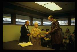
Image depicts a woman holding a sheet of paper in a room with numerous other unidentified individuals. The man standing behind her is possibly Elmer Mercier, a former Mayor of Prince George, B.C.

Map Board?
2012.13.1.133.11 · Item · 1985
Parte de J. Kent Sedgwick fonds

Image depicts a man holding up a board which appears to have maps of the Cottonwood Park on it.

Bridge
2012.13.1.7.163 · Item · June 1986
Parte de J. Kent Sedgwick fonds

Image depicts a bridge in Prince George, B.C.

2012.13.1.3.110 · Item · 12 Oct. 1989
Parte de J. Kent Sedgwick fonds

Image depicts George St in downtown Prince George with City Hall in the background. Also visible are the Prince George Hotel, Ming's Inn Chinese Restaurant, Fraser Stationers Ltd., Weiner King food cart, and a movie theatre. Map coordinates 53°54'55.0"N 122°44'36.1"W

Pine Centre Mall
2012.13.1.3.111 · Item · 12 Oct. 1989
Parte de J. Kent Sedgwick fonds

Image depicts Pine Centre Mall in Prince George, B. C. Map coordinates 53°53'53.2"N 122°46'36.4"W

Yellowhead Bridge
2012.13.1.3.120 · Item · 12 Oct. 1989
Parte de J. Kent Sedgwick fonds

Image depicts the Yellowhead Bridge across the Fraser River. Map coordinates 53°54'45.2"N 122°43'27.9"W

Mr. P.G.
2012.13.1.3.122 · Item · 12 Oct. 1989
Parte de J. Kent Sedgwick fonds

Image depicts Mr. P.G. and the Tourism Information site at the intersection of Highway 16 and 97. Map coordinates 53°53'46.5"N 122°46'00.7"W

Prince George
2012.13.1.3.135 · Item · 12 Oct. 1989
Parte de J. Kent Sedgwick fonds

Image depicts Prince George, possibly with the Northwood Pulpmill in the background.

Salvation Army
2012.13.1.3.112 · Item · 12 Oct. 1989
Parte de J. Kent Sedgwick fonds

Image depicts the Salvation Army on Ospika Boulevard in Prince George, B.C. Map coordinates 53°55'02.6"N 122°47'41.6"W.

Central Street West
2012.13.1.3.115 · Item · 12 Oct. 1989
Parte de J. Kent Sedgwick fonds

Image depicts Central Street West, parallel to Highway 97 in Prince George, B.C. looking north. Shown: Prince George Motors and other car dealerships, Burger King, Grama's Inn, and the Spruceland Shopping Mall sign. Map coordinates 53°54'42.1"N 122°46'53.1"W

Foothills Bridge
2012.13.1.3.123 · Item · 12 Oct. 1989
Parte de J. Kent Sedgwick fonds

Image depicts the Foothills Bridge over the Nechako river on the Foothills Boulevard in Prince George, B.C. Map coordinates 53°56'52.5"N 122°48'59.9"W

Prince George
2012.13.1.3.133 · Item · 12 Oct. 1989
Parte de J. Kent Sedgwick fonds

Image depicts Prince George, possibly with the Northwood Pulpmill in the background.

Bridge
2012.13.1.7.164 · Item · 12 Oct. 1989
Parte de J. Kent Sedgwick fonds

Image depicts a bridge in Prince George, B.C.

Beehive Burner
2012.13.1.3.088 · Item · 12 Oct. 1989
Parte de J. Kent Sedgwick fonds

Image depicts a Beehive Burner along the Nechako on River Road. Map coordinates 53°55'34.1"N 122°44'58.0"W

Salvation Army
2012.13.1.3.114 · Item · 12 Oct. 1989
Parte de J. Kent Sedgwick fonds

Image depicts the Salvation Army on Ospika Boulevard in Prince George, B.C. Map coordinates 53°55'02.6"N 122°47'41.6"W

Lakeland Sawmill
2012.13.1.3.130 · Item · 12 Oct. 1989
Parte de J. Kent Sedgwick fonds

Image depicts the Lakeland Sawmill in Prince George, B.C, identified by the beehive burners; the one with white smoke belonged to Pas Lumber Co. which was bought out by Lakeland in 1987.

Beehive Burner
2012.13.1.3.089 · Item · 12 Oct. 1989
Parte de J. Kent Sedgwick fonds

Image depicts a Beehive Burner along the Nechako on River Road. Map coordinates 53°55'34.1"N 122°44'58.0"W.

Downtown Prince George Businesses
2012.13.1.3.107 · Item · 12 Oct. 1989
Parte de J. Kent Sedgwick fonds

Image depicts 4th Ave at Brunswick St. and the following businesses: Hart Drugs, The Yarn Barn, and Saveco. Map coordinates 53°54'59.9"N 122°44'52.9"W