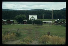
Image depicts a train track and several buildings in an unknown location.
This item is a photograph of a blue and white building in downtown Prince George. The Coast Hotel can be seen in the background.
This item is a photograph of the backside of the United Way building in Prince George in 2006. The Coast Hotel can be seen in the background.
This item is a photograph of the United Way building on the corner of 7th Avenue and Quebec Street, Prince George. The Telus building can be seen in the background.
This item is a photograph of a blue building at 1601 4th Avenue, Prince George. Building includes the Freemason Lodge.
This item is a photograph of the Freemason building at 480 Vancouver Street, Prince George.
This item is a 35 mm photograph negative of the CNR bridge over the Fraser River. Photograph was taken in the fall from Cottonwood Park, Prince George.
This item is a 35 mm photograph negative of the Nechako River, Prince George. Water level is very low.
Photograph depicting a dirt road winding between grass and trees in Soda Creek.
Photograph depicting a garden and backyard in someone's personal residence.
Photograph depicting Kent Sedgwick and a dog in someone's garden and personal residence.
Photograph depicting a dog laying in the grass in someone's backyard of a personal residence.
File consists of notes, clippings, and reproductions relating to the Prince George school dormitories. Includes: "Old Dormitory Property - Senior Citizens Development" typescript letter from the Secretary-Treasurer of School District #57 to Mr. Jefferies, City Manager (20 June 1979).
Image depicts the old jail house in Soda Creek, B.C.
Image depicts an old building located somewhere are the Pickard farm north of Soda Creek, B.C.
The item is a photograph depicting a house at 1705 Fir Street, Prince George. Annotation on the back of the photograph states, "1705 Fir St. - N. of F-C school at 17th. 1st Cath. Church off reserve Sept. 13? Rev. Rivet."
The item is a photograph depicting the exterior of old damaged buildings on the Moffat farmland. There is a fence at the entrance to the driveway with an address sign that reads "1820." Annotation on the back of the photograph states, "Moffatt (Gunn) farm 2005."
The item is a photograph depicting the exterior of old damaged buildings on the Moffat farmland. There is a fence at the entrance to the driveway with an address sign that reads "1820."
The item is a photograph depicting the exterior of old damaged house on the Moffat farmland. There is a broken fence at the rear of the house, broken windows and a collapsed roof.
Image depicts the Harrison House in Kersley, B.C.
Image depicts two rows of houses in an unknown location.
Image depicts the old jail house in Soda Creek, B.C.
The item is a photograph depicting the exterior of old damaged buildings on the Moffat farmland. There is a fence at the entrance to the driveway with an address sign that reads "1820."
Photograph depicts the graves of Edmund Shepherd, Elsie Rankin, and Elize Shepherd at the Soda Creek Cemetery.
Photograph depicts a monument and grave stone for Captain Frank Odin of the Steamboat Charlotte. Annotation on verso: "Capt. Odin Monument, Soda Creek cemetery, 2010".
Photograph depicting an abandoned building in Soda Creek, the building surrounded by overgrown grass and trees.
Photograph depicting a dirt field surrounded by green trees.
Photograph depicting a garden and backyard in someone's personal residence.
Photograph depicting Kent Sedgwick and a dog in someone's garden and personal residence.
File consists of transcript of an oral interview with Trelle Morrow regarding the architectural development of Quinson Elementary School.
This item is a photograph of a yellow parkade in downtown Prince George.
This item is a 35 mm photograph negative of the Nechako River, Prince George. Water level is very low.
File consists of clippings, notes, and reproductions relating to World War 2 in Prince George. Includes various clipped articles from the Prince George Citizen newspaper; "Wartime bldgs" handwritten notes by Kent Sedgwick (2005); and a John Bogle UNBC history course paper (1999). Also includes photographs taken in 2005 of various buildings and houses in Prince George.
The item is a photograph that depicts the front of a beige house at 321 North Moffat Street.
File consists of notes, clippings, and reproductions relating to churches in Prince George. Includes photographs depicting paintings of churches in Prince George and area. Also includes a 2005 DVD entitled "Rose Prince".
File consists of notes and reproductions relating to a heritage house at at 1111 Connaught Drive, Prince George, which was the residence of Dr. John McArthur. Dr. John McArthur was a general practitioner in Prince George, who was involved with community life, including coaching of the local PG Senior Hockey Team.
The item is a photograph depicting the back of the house located at 2540 Hazelton Street, Prince George. The house has grey stucco and is two stories.
The item is a photograph depicting a white residential house off the Cariboo Highway.
The item is a photograph depicting a residential duplex house off the Cariboo Highway.
The item is a photograph depicting a white residential house at 7295 Cummings Road. House was relocated in 1976.
The item is a photograph depicting the Prince George airport terminal. Photograph taken prior to fire.
The item is a photograph depicting a residential duplex house off the Cariboo Highway. It is one of three buildings that were relocated for the airport in 1957.
The item is a photograph depicting a residential duplex house off the Cariboo Highway. It is one of three buildings that were relocated for the airport in 1957
The item is a photograph depicting a residential duplex house off the Cariboo Highway.