Affichage de 221 résultats
Archival description
Job 626 - Haida Tribal Society - Facilitation and Process Advice on Development of a Marine Use Strategic Plan - Haida Gwaii
Job 626 - Haida Tribal Society - Facilitation and Process Advice on Development of a Marine Use Strategic Plan - Haida Gwaii
Job 664 - Misty Isles Economic Development Society - Food Planning Presentations on Haida Gwaii - Haida Gwaii
Job 664 - Misty Isles Economic Development Society - Food Planning Presentations on Haida Gwaii - Haida Gwaii
Job 539 - Queen Charlotte Islands Forest District - Facilitation and Mediation of Local Resource Use Plan for Tlell Watershed - Tlell River
Job 539 - Queen Charlotte Islands Forest District - Facilitation and Mediation of Local Resource Use Plan for Tlell Watershed - Tlell River
Linguistic studies and sermons
Linguistic studies and sermons
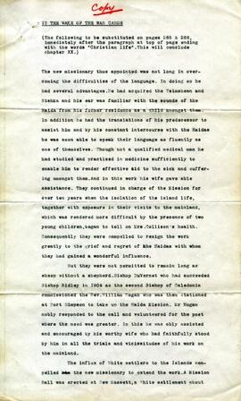
"In the Wake of the War Canoe" Chapter XX revisions
W.H. Collison's speech booklet
W.H. Collison notebook (1)
W.H. Collison notebook (1)
W.H. Collison notebook (2)
W.H. Collison notebook (2)
Notes and drafts
Notes and drafts
W.H. Collison correspondence
W.H. Collison correspondence
Cartographic Materials Series
Cartographic Materials Series
Archdeacon W. H. Collison fonds
Archdeacon W. H. Collison fonds
Publications Series
Publications Series
W.H. Collison manuscript
W.H. Collison manuscript
Queen Charlotte Islands General Development Company, Ltd.
Queen Charlotte Islands General Development Company, Ltd.
Jill Singleton Collection
Jill Singleton Collection
Photographs
Photographs
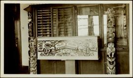
Model wooden totem poles and bentwood box

Sketches of Harbours, Queen Charlotte Islands, 1878

Advanced Copy of a Map of the Queen Charlotte Islands
Map showing locations of placer streams in British Columbia south of latitude 54 degrees North, with Queen Charlotte Islands inset in north east corner
Map showing locations of placer streams in British Columbia south of latitude 54 degrees North, with Queen Charlotte Islands inset in north east corner