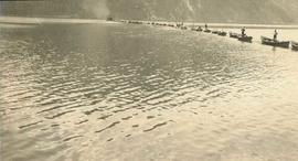
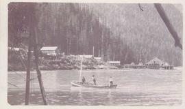
Photograph depicts three men fishing in a boat with a cannery and wooden buildings along the forested shoreline in the background.
Photograph depicts a line of cannery fishing boats being towed across the water with the base of a mountain in the background.
Photograph depicts white rapids at bottom of waterfall in Bulkley River, B.C. Fishing territory visible on far right; hill on opposite shore in background.
Photograph depicts Iona Campagnolo and an unknown man looking over the sawmill owned by Rim Forest Products in Hazelton.
Photograph depicts Iona Campagnolo and a man wearing a hard hat and ear protection at a sawmill owned by Rim Forest Products in Hazelton.
Photograph depicts Iona Campagnolo wearing a hard hat and speaking with an unknown man in front of a lumber pile at a sawmill owned by Rim Forest Products in Hazelton.
Photograph depicts Iona Campagnolo talking with a logging truck driver of Frank Beban Logging at Athili Gwaii (Lyell Island) during a 1978 Skeena riding tour.
Photograph depicts an unidentified fishing boat at the Prince Rupert marina. Several other fishing boats are visible in the background.
Photograph depicts the "Northern Dawn" and an unidentified fishing boat at the Prince Rupert marina.
Photograph depicts Iona Campagnolo talking with an unidentified employee of Frank Beban Logging while standing beside a large piece of heavy machinery.
Image depicts the entrance to a mine with an unknown individual present. It is possibly the entrance to the closed Britannia Mine in the Howe Sound Region.
Image depicts a conveyor belt, possibly located inside one of the old buildings at what is possibly the closed Britannia Mine.
Image depicts a piece of industrial machinery, possibly located at the closed Britannia Mine. Two unknown individuals are also present in the image.
Image depicts what appears to be the old, abandoned mill in Lamming Mills, B.C.
Image depicts numerous tree logs floating on a body of water. The location is uncertain, but is likely Eaglet Lake.
Image depicts the mill site at Giscome, B.C. Map coordinates 54°04'19.7"N 122°22'04.7"W
Image depicts the mill site at Giscome, B.C. A sign in the foreground reads "Maynard's Industrial Auctioneers." Map coordinates 54°04'19.7"N 122°22'04.7"W
Image depicts a food stand at the mill site at Giscome, B.C. Map coordinates 54°04'19.7"N 122°22'04.7"W
Image depicts what is possibly the Alcan smelter in Kitimat, B.C.
Image depicts the site of Giscome's first quarry, with Eaglet Lake located in the foreground.
Image depicts the office at the Northwood Upper Fraser Saw Mill and a sign which reads "Have a safe, quality day." Map coordinates 54.117916, -121.943351
Image depicts a view of a saw mill in Chetwynd, B.C.
Image depicts the Lajoie hydroelectric generating station at the Lajoie Dam on the Bridge River (view of powerhouse and tailrace from top of dam).
Image depicts what is possibly an old, rundown mill in Bralorne, B.C.
Image depicts the old sales office of Bralorne Pioneer Mines Ltd. which is now the Bralorne Pioneer Museum.
Image depicts the Gibraltar mine site north of Williams Lake, B.C.
Image depicts a number of workers putting in blasting powder at the Gibraltar mine site north of Williams Lake, B.C.
Image depicts the BCR tracks passing through a mill somewhere near the 100 Mile.
Image depicts an aerial view of the Gibraltar mine site's pits and waste dumps, north of Williams Lake, B.C.
Image depicts what appears to be a sawmill at 100 Mile House, B.C.
Image depicts an 80 tonne truck at a mine site somewhere in Granisle, B.C.
Image depicts a large, old piece of machinery, possibly some form of mining or prospecting equipment; it is located in Quesnelle Forks, B.C.
Photograph depicts a C.P.R. lumber train at Cowichan Lake to go to Crofton Mill on Vancouver Island.
Photograph depicts a general view, looking north, of Westview Harbour with the Powell River paper plant smoking in the background.
Photograph depicts the newsprint plant of MacMillan, Bloedell, and Powell River Ltd. In Powell River, B.C. The view is looking northwards and shows that the plant is working on Easter Day/
Photograph depicts a log boom probably in the Lower Mainland or on Vancouver Island.
Photograph depicts a view of a steam donkey probably at Sayward near Kelsey Bay on North Vancouver Island.
Photograph depicts an early spool donkey at the Cowichan Valley Forest Museum
Photograph depicts a scow with chips landing on the north shore of Vancouver harbour. There are Saskatchewan wheat elevators in the background.
Photograph depicts a general view of a Horne Bros. Ltd. shingle mill on #305 West Esplanade Rd. in North Vancouver.
Photograph depicts a view of the booming ground of the Horne Bros. Shingle Co. Ltd. On #305 West Esplanade Rd. in North Vancouver.
Photograph depicts an oxen powered log carrier with wheels that are approximately 10 feet in diameter. It is at Pioneer Park and Museum near Totem Lake, 3 miles north of Yahk and 30 miles east of Creston.
Image depicts a Beehive Burner along the Nechako on River Road. Map coordinates 53°55'34.1"N 122°44'58.0"W
Image depicts a saw cutting a log in half at a saw mill in Prince George, B.C.
Image depicts the interior of a saw mill somewhere in Prince George, B.C.
Image depicts several pieces of heavy machinery used in forestry. The Coast Inn of the North is seen in the background.
Image depicts a logging area somewhere near Prince George, B.C.