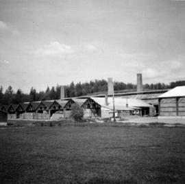
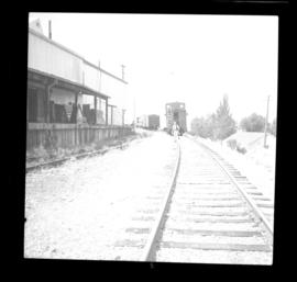
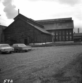
Photograph depicts the west side of the C.P.R. engineering shops at Revelstoke. The building appeared to house a machine shop and had no cars or locomotives inside.
Photograph depicts a depot and derelict electricity substation at Coghlan, 9 rail miles east of Langley, looking west.
Photograph depicts the Canadian National Railway (CN) Port Mann depot.
Photograph depicts the Great Northern Railway depot at Keremeos and the terminus of the line from Wenatchee, Washington, U.S.A. The line stops about 1/3 mile beyond this point. At one time it ran on to Hedley mine and possibly Princeton.
Photograph depicts the completely rebuilt drug store in Barkerville based on historical sketches and photos.
Photograph depicts a disused cabin that was perhaps abandoned in the late 1950's.
Photograph depicts the Pacific Press Ltd. Vancouver Sun building at Beatty and West Pender St. The view is looking northeast from Beatty St. It was vacated by the Vancouver Sun at Christmas 1965 with the neon "Sun" sign on the tower removed.
Photograph depicts Pier B of C.P.R., just west of the C.P.R. railway station. This is the only pier accessible to ocean going passenger liners and is used by P&O vessels. Facilities generally in adequate for the 1960s.
Photograph depicts a former fire hall now used as a boy's club on 12th Ave and St. Catherine's St., in Vancouver, B.C. It is one and a quarter miles southeast of C.N.R. station.
Photograph depicts St. Paul's Anglican Church in Powell River. The church was built in 1955.
Photograph depicts a Roman Catholic church, "Our Lady of Lourdes," on the First Nations reservation, Sechelt Village. It was built in 1907 and is now closed, but the heavy bell is still in position in the belfry.
Photograph depicts a barn at Lund, a village 12 miles north of Powell River. This building overlooks the harbour.
Photograph depicts a house on Ladner Trunk Rd. in Delta, B.C. It is in the northeast corner of an intersection with the road leading to the Canadian Army Signal Station.
Photograph depicts the B.C. Forest Service Ranger's administration and equipment building at Pender Harbour in Sechelt, B.C.
Photograph depicts a settler's log cabin, about 1 mile from the main road of Sechelt Peninsula and on the side road leading to Gordon Bay, at a point where a small stream cease to be tidal. Vertical cracks in logs stuffed with rags and horizontal cracks filled with cement.
Photograph depicts a Chinese farmer's buildings on the Port Guichon Rd. on the outskirts of Ladner, B.C.
Photograph depicts a post office on Main St. in Cumberland on Vancouver Island. It was built in 1907 in a similar style to the building in Ladysmith.
Photograph depicts a Ukrainian Greek Orthodox Church on 27th St. and 41st Ave. in Vernon, B.C. in the Okanagan.
Photograph depicts the brick works at Haney, B.C., within 100 yards of the Fraser River. Current production appeared to be bricks, tiles, and flowerpots. There is a disused railway spur in the works
Photograph depicts a courthouse in Vancouver, B.C. Photo shows the ripped up forecourt.
Photograph depicts a courthouse on Georgia St., looking west towards the Vancouver Hotel. The fence surrounding the courthouse is covered with paintings.
Photograph depicts a painting on the fence outside a courthouse on Howe and Granville St. In Vancouver, B.C. Each artist was granted a permit and panel by City Council.
Photograph depicts a wharf at Lang Bay, 14 miles southeast of Powell River. In fair repair, now used only by an oil company to pump in oil to a storage depot behind the camera.
Photograph depicts block ships sunk to protect booming grounds at Powell River. The ships were former wartime naval vessels.
Photograph depicts a general view, looking north, of Westview Harbour with the Powell River paper plant smoking in the background.
Photograph depicts the newsprint plant of MacMillan, Bloedell, and Powell River Ltd. In Powell River, B.C. The view is looking northwards and shows that the plant is working on Easter Day/
Photograph depicts a view of former C.P.R. steam locomotive sheds at North Bend, B.C. in the Fraser Canyon.
Photograph depicts a disused Canadian National Railway (CN) passenger depot at Kelowna. The offices still used for parcels, ticket sales, etc. There is still good freight traffic.
Photograph depicts a liquor store and church on Main St. in Lillooet, B.C.
Photograph depicts a courthouse in Vancouver, B.C. Photo shows the ripped up forecourt.
Photograph depicts the Hospital Cottage on Main St. in Sechelt, B.C. which also appears to have been home to the Magistrates and Small Debts Court at one point. A large central hospital for the whole of the Sechelt Peninsula was opened in 1965 at Sechelt.
Photograph depicts Cadero St. in the west end of Vancouver, looking north from Barclay St. intersection in the 800 block.
Photograph depicts the C.P.R. Shuswap Depot east of Kamloops.
Photograph depicts the water tower at the C.P.R. Savona Depot. The view is looking east towards Kamloops.
Photograph depicts a disused water tower 50 yards from the C.P.R. Shuswap Depot, looking west towards Kamloops.
Photograph depicts the C.P.R. Savona Depot looking east.
Photograph depicts the C.P.R. wharf-scow approach ramp at Kelowna, looking east. Okanagan Lake is behind the camera.
Photograph depicts the C.P.R. station at North Bend, B.C., from a view looking north.
Photograph depicts the C.P.R. station at Spences Bridge. The view is looking south at a departing freight train.
File consists of documentary photographs taken by David Davies of public railways, mainly belonging to the Canadian Pacific Railway in British Columbia.
Photograph depicts the C.P.R. depot at Canal Flats on the Golden-Cranbrook line. The ex box car depot now is used only to make line phone calls.
Photograph depicts the Canadian National Railway (CN) freight depot at Penticton, with a motor/rail tractor in the photo.
Photograph depicts the Sun Building at the intersection of Beatty and West Pender St. in Vancouver, B.C. The photo was taken after the Pacific Press Ltd. Vacated the building on December 26, 1965, and the "Sun" neon sign on the tower was removed. The view is looking west from West Pender St.
Photograph depicts a shop on the north side of Main St. in Cumberland on Vancouver, Island.
Photograph depicts the derelict CPR depot at Hope, part of the former Kettle Valley line. A spur of about 3 miles still exists between the Odlum junction with the main line on the north side of the Fraser River and this depot, and continues southeast to a point near the CNR. It is not abandoned, but little used. The Hope yard has a 47 car capacity.
Photograph depicts the CPR line at Osoyoos at the BC Tree Fruits Ltd. warehouse and spur. This is about 1 mile north of the depot. The daily freight train from Penticton is returning from Osoyoos, having just collected 1 boxcar of fruit, backing onto caboose. This is approximately at mile 35.4 from Penticton.
Photograph depicts a courthouse in Richfield, 1 mile above Barkerville. It was the only building left standing of the former mining community.
Photograph depicts a church that was built of shaped logs on the territory of the Tsal'alh Nation on the road leading to Seton Lake. Church was derelict, but still held pews, plastic flowers and small shrines.
Photograph depicts "Butterchurch" that was built in 1870 under the direction of Father Rondeault of the Oblate Order for missionary work among the Comiakan Natives, a tribe of about 100. It was abandoned by about 1880 because of its location. It was recently restored as a historical shrine.
Photograph depicts a completely rebuilt saloon that was done so based on historical sketches and photos.