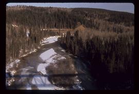
Image depicts a bridge under construction in Tumbler Ridge, B.C.
Image depicts a view of the scenery in Tumbler Ridge, B.C.
Image depicts an aerial view of South Tweedsmuir Provincial Park.
Image depicts an aerial view of Glacier Mountain in South Tweedsmuir Provincial Park.
Image depicts a view of South Tweedsmuir Provincial Park.
Image depicts a lake in South Tweedsmuir Provincial Park.
Image depicts a lake in South Tweedsmuir Provincial Park. There is an unknown individual present in a canoe with the camera-man.
Image depicts a river in South Tweedsmuir Provincial Park. There is an unknown individual present in a canoe with the camera-man.
Image depicts Kent Sedgwick standing beside a wrecked plane somewhere in South Tweedsmuir Provincial Park.
File contains slides depicting the Woolsey and Place Glaciers.
Image depicts two unknown individuals at the Place Glacier.
File contains slides depicting areas around the Discovery Passage.
Image possibly depicts the Fraser River from Highway 97 near Quesnel, B.C.
Image depicts some farmland near Alexandria, B.C.
Image depicts the property of an old ranch at Mile 108 of Highway 97.
Image depicts what is likely the Dunkley Lumber Mill in Strathnaver, B.C.
Image depicts an aerial view of Highway 97 just north of Williams Lake, B.C.
Image depicts an aerial view of Diamond Island, near Quesnel, B.C.
Image depicts the cutbanks of the Fraser River at Soda Creek, B.C.
Image depicts two individuals on a canoe on Big Bar Lake north of Clinton, B.C..
Image depicts a large flock of ducks in a field full of water at an unknown location.
Image depicts a river at an uncertain location.
Image depicts the Fraser River, south of Soda Creek, B.C.
Image depicts the Fraser River, looking south from Marguerite, B.C.
Image depicts a farm on the west side of the Fraser, south of Quesnel, B.C.
Image depicts an old log cabin with the sign "Robin Hood Flour" on it at an uncertain location. It is possibly at the 153 Mile House.
Image depicts a scenic view of a section of land at an unknown location.
Image depicts what is likely a slump slide at an unknown location.
Image depicts the cemetery in Soda Creek, B.C.
Image depicts a view of a river from the Cottonwood Bridge.
Image depicts a sawmill somewhere in Quesnel, B.C.
Image depicts numerous wood piles near the sawmill somewhere in Quesnel, B.C.
Image depicts a sawmill somewhere in Quesnel, B.C.
Image depicts what appears to be a farm at an uncertain location.
Image depicts a river, possibly the Fraser, at an uncertain location.
Image depicts an unknown individual standing near what is most likely a slump slide at an uncertain location.
Image depicts an area of disturbed ground, most likely due to a landslide, at an unknown location.
Image depicts two unknown individuals standing near what is most likely a slump slide at an uncertain location.
Image depicts an area of placer mining at Hixon Creek in Hixon, B.C.
Image depicts a chasm full of trees at an unknown location.
Image depicts numerous buildings in Hendrix Lake, B.C.
Image depicts rail road tracks through a forest, as well as a river; located in Soda Creek, B.C.
Image depicts the old community hall in Soda Creek, B.C.
Image depicts an old building located somewhere are the Pickard farm north of Soda Creek, B.C.
Image depicts the Flying U Ranch at 70 Mile House, B.C.
Image depicts several people standing near the Hixon Falls in Hixon, B.C.
File contains slides depicting Highway 16 West, from Isle Pierre to Hazelton.