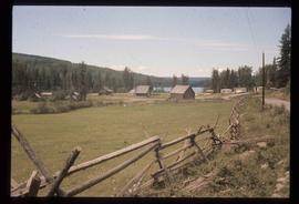
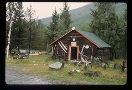
Image depicts an old, half-collapsed house in Likely, B.C.. The slide labels it as "Bullion house."
Image depicts a field of hay somewhere in Beaver Valley.
Image depicts the Cariboo Lake, with the roof of an old log cabin visible.
Image depicts the Cariboo River.
Image depicts the old log buildings of the town of Hydraulic, B.C.
Image depicts a bridge, and the town of Likely on the the other side of a river.
Image depicts the town of Horsefly, B.C.
File contains slides depicting places in and around Mackenzie Town.
Image depicts numerous individuals inside a mall in Mackenzie, B.C.
Image depicts numerous individuals seated around a table and apparently having a meeting at an uncertain location in Mackenzie, B.C.
Image depicts numerous individuals examining a map as they are seated around a table. The location of the meeting is somewhere in Mackenzie, B.C.
Image depicts numerous vehicles parked outside a building with a sign which reads "Mackenzie Centre;" it is possibly the mall in Mackenzie, B.C.
Image depicts numerous individuals wearing hard hats in what appears to be a computer room somewhere in Mackenzie, B.C.
Image depicts the frozen Morfee Lake just to the East of Mackenzie, B.C. The slide is also labelled "sub-boreal," referencing that it is a sub-boreal spruce zone.
Image depicts the Mackenzie Reservoir in Mackenzie, B.C.
Image depicts a trailer park in Mackenzie, B.C.
Image depicts a row of houses in Mackenzie, B.C.
Image depicts the Mackenzie Curling Rink.
Image depicts a small section of Mackenzie, with the Mackenzie Curling Rink visible on the right side of the image.
Image depicts St. Peter's Church in Mackenzie, B.C.
Image depicts a residential area with a playground somewhere in Mackenzie, B.C.
Image depicts numerous condominiums somewhere in Mackenzie, B.C.
Image depicts a trailer park somewhere in Mackenzie, B.C.
Image depicts numerous vehicles in the parking lot of a mall in Mackenzie, B.C.
Image depicts several apartment buildings and the sign for a Gulf Gas Station in Mackenzie, B.C.
Image depicts a row of houses in Mackenzie, B.C.
Image depicts an individual standing next to the world's largest tree crusher in Mackenzie, B.C.
Image depicts the world's largest tree crusher in Mackenzie, B.C.
Image depicts a truck parked on a beach in Mackenzie, B.C.
File contains slides depicting places in and around Manson Creek.
Image depicts the Germansen River, with the buildings of Germansen Landing visible on the other side.
Image depicts a camper parked on the shore of Nation Lakes, south of Manson Creek, B.C.
Image depicts a bridge over the Nation River somewhere south of Manson Creek, B.C.
Image depicts the Nation River somewhere south of Manson Creek, B.C.
Image depicts the road to Manson Creek, B.C.
Image depicts a man and his family filling up their truck with gas at Manson Creek, B.C.
Image depicts the Omineca Museum in Manson Creek, B.C.
Image depicts Manson Creek, B.C.
Image depicts the gas station at Manson Creek, B.C.
Image depicts a creek with a half collapsed shack in the background somewhere in Manson Creek. The slide is labelled "Manson workings."
Image depicts a bridge over the Omineca River near Germansen Landing, B.C.
Image depicts a helicopter in Germansen Landing, B.C.
Image depicts a child in the foreground, and the Germansen Landing trading post in the background in Germansen Landing, B.C.
Image depicts the Germansen Landing Trading Post.