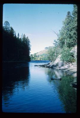
Image depicts the Fraser River from Northwood Road in the Prince George area.
Image depicts the Stellako River.
Image depicts the rubble of a demolished house at Island Cache, with several other buildings in the background.
Image depicts a junk pile of bottles, cans and bags, as well as the gutted frame of an old car, at Island Cache.
Image depicts an area of cut trees at Island Cache.
Image depicts numerous houses, and an unknown child standing in a street at Island Cache.
Image depicts a street in Island Cache.
Image depicts a few houses in Island Cache.
Image depicts a street in Island Cache.
Image depicts Wells, B.C.
Image depicts a sunshine recorder at an uncertain location.
Image depicts two unidentified individuals and a van on a farm at an uncertain location, possibly a place called Cypress Hill, with an atmometer and a sunshine recorder.
Image depicts the shore line and surrounding land of a lake or river at an airport, possibly in Prince George, B.C.
Image depicts a bulldozer and truck in an unknown location.
Image depicts a Hydraulic Placer mining location in Barkerville which has been completely deforested.
Image depicts a number of small houses at Island Cache.
Image depicts several old, ruined cars and an unknown individual in Island Cache.
Image depicts what appears to be an animal pen in Island Cache. There is a goat and numerous chickens in the image, as well as a pile of miscellaneous material.
Image depicts a few houses in Island Cache. There are two unknown individuals present.
Image depicts the Stellako River.
Image depicts a Fisherman wading in the Stellako River.
Image depicts the Rearguard Falls in Rearguard Falls Provincial Park near Tête Jaune Cache along the Yellowhead Highway.
Image depicts a view of what is possibly the Yellowhead Pass on the British Columbia-Alberta border, west of Jasper A.B.
Image depicts a view of Tabor Mountain in Prince George, B.C.
Image depicts an evaporation pan for water evaporation measurements. The location is uncertain.
Image depicts the cableway, stretching over a river, in Willow River, B.C.
Image depicts the cableway in Willow River, B.C.
Image depicts a view of Francois Lake.
File contains slides depicting Island Cache on Cottonwood Island in Prince George, B.C.
Image depicts some fallen trees at Island Cache.
Image depicts two dogs and numerous chickens in a yard at Island Cache.
Image depicts the bank of the Nechako River at Island Cache.
Image depicts a few houses and a dog on a porch at Island Cache.
Image depicts a body of water in Island Cache. It is possibly a small section of the Nechako River.
Image depicts Stuart Lake in Fort St. James, B.C.
Image depicts the Fraser River from Highway 97 near Quesnel, B.C.
Image depicts a couple of salmon in the Stellako River.
Image depicts a view of Francois Lake.
Image depicts a number of small houses at Island Cache.
Image depicts a stand of trees and a shed at Island Cache.
Image depicts what is likely an outhouse at Island Cache.
Image depicts a clearing at Island Cache.
Image depicts an atmometer. According to the slide, it is being used for measuring the rate of water evaporation "from carborundum stone." The location is uncertain.
Image depicts a snow gauge at an uncertain location.
Image depicts what is possibly an intrusive volcanic landform somewhere near Miworth, B.C.
Image depicts Mt. Robson.
Image depicts an unidentified individual standing next to a marker and a stake at an uncertain location.
Image depicts objects, including a flag pole, that the slide labels as "survey equipment." The slide also places it as a "Peyto icefall," on the Peyto Galcier in the Banff National Park in Alberta, B.C.
File consists of a pamphlet titled "The Fort Fraser-Fort George Bulletin Area" prepared by the Department of Lands, Forests, and Water Resources from the Province of British Columbia.
File contains slides depicting the Woolsey and Place Glaciers.