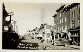
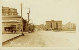
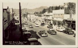
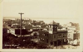
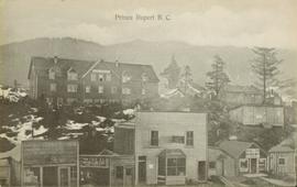
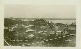
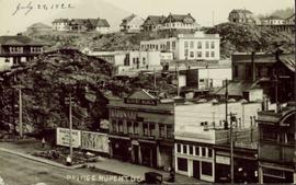
Slightly elevated street view of several Prince Rupert storefronts. A large pile of rubble is visible on the left of the photograph. Printed annotation on recto reads: " Prince Rupert BC." Handwritten annotation on recto reads: " July 29, 1922."
Slightly elevated street view of a large pile of rubble next to several storefronts in Prince George. Printed annotation on recto reads: "Prince Rupert BC."
Side perspective street view of the Royal Hotel in Prince Rupert BC. The "Ladies [sic] Entrance" sign is visible on the right side of the building. Several vehicles can be seen on the street. Printed annotation on recto reads: " 3rd Ave Prince Rupert Photo W.W.W."
Side perspective street view of the Canadian Bank of Commerce on a deserted dirt road. Printed annotation on recto reads: "2nd Ave Prince Rupert BC." Illegible faded photographer's mark on lower right corner. Handwritten annotation on verso reads: "The houses and pavements are made of wood. Love Daddy. xx." Postcard is addressed to: "Miss Greta Poole 'Airoudale'[??] Collingwood Road Paigulou Devon England." Postmark on verso reads: "Prince Rupert BC 10:30 AM Aug 5 1925."
Elevated view of Third Avenue in Prince Rupert. Several cars and delivery trucks are visible driving along the road. Printed annotation on recto reads: "3rd Ave Prince Rupert BC Photo by Wrathalls."
Overhead view of many commercial buildings in Prince Rupert, BC. Printed annotation reads: "Prince Rupert, BC."
Front view of several commercial buildings in Prince Rupert, BC. Visible are "The Ideal Clothing & Shoe Store," "Bailey and Bell Bakers," and "Hotel Premier." Printed annotation on recto reads: "Prince Rupert, BC." Handwritten annotation on verso reads: "Dear Peggy, Mailui[??] will show you where [illegible] and Dunn Florence [illegible] when you come in Prince Rupert you will see this [illegible]. Aunt Florence." Postcard is addressed to: "Margaret [Illegible] Suby Seabold. Kipap County Washington[??]. Verso is affixed with a Canadian one Cent stamp. Postmarks on verso read: "[Illegible] WASH Sep 6 19[??] Prince Rupert B.C. SP 2 69."
Photograph of Prince Rupert businesses amidst clear cut stumps. Businesses include "Stewart and Mobley Groceries, Fruits and Produce." Printed annotation on recto reads: "Prince Rupert, B.C., Oct. 09."
Photograph depicts hotel on corner of street, crowd and cars in foreground.
Handwritten annotation on verso “Albert Johnson’s 'Northern Hotel' South Fort George 1914".
Photograph depicts small buildings with canvas roofs and signs reading: "Do Drop In, Ladies & Gents Furnishings Boots & Shoes, Two Per Cent Beer." One woman, nine men,and three dogs can be seen in image.
Handwritten annotation on verso: “Prairie Creek 1912".
Photograph depicts two men standing in front of very small wood building with tarp-covered roof. Chair and paper documents can be seen in front of building, trees and rough cleared land in background.
Handwritten annotation on verso: “The first newspaper office, South Fort George 1910."
Group of unidentified individuals sit at tables in background, and one man stands in doorway.
Handwritten annotations on verso read: “Return to Tom,” and “Iona presenting memorial plaque to Mrs. Nathan Barton at NCDC Meeting, Prince Rupert / Sept. 77.”
Subseries consists of correspondence and accompanying informational material related to the Department of Industry, Trade and Commerce and northern British Columbia commercial issues. Records include press releases, reports, informational pamphlets, brochures, and newspaper clippings. Includes correspondence regarding industrial research and development in northern BC; Cassiar Asbestos mine improvements; the Vancouver Trade and Convention Centre; conversion to the metric system; Trident Trigull aircraft; the Federal Business Development Bank; the Enterprise Development Program; and inquiries to the Ministry of State for Small Business.
Photo of entire ship building plant, including several vessels in the foreground. Hills are visible in the background. Annotation on recto reads: "Prince Rupert Ship Repair and Ship Building Plant. Prince Rupert BC. Frank E Kirby, William T Donnelly, Engineers. 17 Battery Place. NYC."
View of the road descending to the waterfront. Buildings and forested area are visible on either side of street. Mountains clear in the background.
Wide angle photograph showing the intersection of 3rd Avenue and 6th Street, as well as 5th Street in Prince Rupert. Many buildings are visible along the wooden street including a building in mid-construction. Annotation on recto reads: "Prince Rupert, BC. 6th Street 3rd Ave. 5th St Allen Photo Aug 6/09."
Photograph of a train traveling through Prince Rupert. Several people are gathered on the dock and around various buildings. Two small vessels are docked in the harbour. Annotation on recto reads: "Prince Rupert, Waterfront. Allen Photo May '4."
Image depicts downtown Prince George looking northwest across Dominion Street. Map coordinates 53°54'48.7"N 122°44'45.6"W
Image depicts 4th Ave at Brunswick St. and the following businesses: Hart Drugs, The Yarn Barn, and Saveco. Map coordinates 53°54'59.9"N 122°44'52.9"W
Image depicts 4th Ave at Quebec St, showing the following businesses: The Yarn Barn, Golden Chalice Jewellers, Dandy Lines, Ultrasport, and Saveco. Map coordinates 53°54'58.6"N 122°44'47.5"W
Image depicts 3rd Ave in Prince George, B.C. Map coordinates 53°55'01.9"N 122°44'48.7"W
Image depicts downtown Prince George, B.C.
Image depicts the Ramada Hotel in Prince George, B.C.
Image depicts an aerial view of Pine Centre Mall and Masich Place Stadium in Prince George, B.C.
Image depicts the Prince George Multiplex.
Image depicts the House Hotel in Barkerville, B.C.
Image depicts a building somewhere in Wells, B.C. There is a sign in one window which reads "Lon Oddfrey Insurance Realty LTD."
Image depicts a crowd of people outside the Wells Hotel in Wells, B.C.
Image depicts the interior of an old convenience store; numerous unknown individuals are present. It is located at the 153 Mile House.
Image depicts a street in Telkwa, B.C.
Image depicts a grocery store at Island Cache.
Image depicts the Jack O' Clubs Hotel in Wells, B.C. It burned down on February 14th, 1994
File consists of one pulp dollar bill made of thick paper.
Image depicts the Garrett Store in Atlin, B.C. A plaque on it reads: "John Garrett, a prominent English cricket player, came to Atlin in 1910 to mine gold. In 1917 he opened this grocery and dry goods store where he also sold his wife's fresh baked bread and sweets."
The item is a business focused newspaper from Central Interior Business focusing on business and economics in the central interior British Columbia.
Image depicts a street in McBride, B.C. One of the store signs reads "Allied Hardware."
Image depicts the Upper Fraser General Store in Upper Fraser, B.C. Two other signs indicate that it is also a post office and a place that offers propane refills. Map coordinates 54°07'10.8"N 121°56'51.7"W
Image depicts several businesses in a small section of Chetwynd, B.C. There is a motor hotel and a half-visible sign for an Esso gas station.
Image depicts several unidentified individuals standing in front of a store selling honey.
Image depicts the interior of a store, possibly in Fort St. John, B.C.
Image depicts the Caribou Hotel and the Matthew Watson General Store in Carcross, Y.T.
Image depicts the Germansen Landing Trading Post.
Image depicts an old building on the main street of Prince Rupert, B.C. Only half of the business name is visible: "Skeena Color [sic]."
Image depicts the Bank of Nova Scotia located on "Besner Block" in Prince Rupert, B.C.