Showing 3346 results

Archival description
1480 results with digital objects Show results with digital objects
2000.1.1.3.13.13 · Item · 1959
Part of Cassiar Asbestos Corporation Ltd. fonds

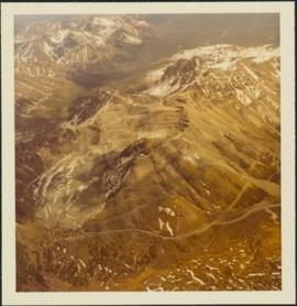
Photograph depicts the North peak of McDame mountain in the earlier stages of strip mining, South peak unmined in background. Quonset and other shops visible in left foreground, unknown building built into mountainside in right foreground.

Strip Mining, 1971
2000.1.1.3.13.14 · Item · 1971
Part of Cassiar Asbestos Corporation Ltd. fonds

Photograph depicts the Cassiar mine after extensive strip mining. It is believed that the North and South peak stand in background, and the West peak in foreground. Handwritten annotation on recto of photograph: "1971".

Strip Mining & Cirque Dump
2000.1.1.3.13.20 · Item · [ca. 1973]
Part of Cassiar Asbestos Corporation Ltd. fonds

Photograph depicts the Cassiar mine. North peak featured in left background, South peak in right background, and West peak in right foreground. Area to left of the mining pit and West peak was called the "cirque waste dump." Location of new mine garage can be seen just above the "#7 switchback" road in bottom right foreground.

Strip Mining & Cirque Dump
2000.1.1.3.13.21 · Item · [ca. 1973]
Part of Cassiar Asbestos Corporation Ltd. fonds

Photograph depicts the Cassiar mine. North peak featured in left background, South peak in right background, and West peak in right foreground. Area to left of the mining pit and West peak was called the "cirque waste dump." Mountain range visible in distance.

Strip Mining & Cirque Dump
2000.1.1.3.13.22 · Item · [ca. 1973]
Part of Cassiar Asbestos Corporation Ltd. fonds

Photograph depicts the Cassiar mine. North peak featured in left background, South peak in right background, and West peak in right foreground. Area to left of the mining pit and West peak was called the "cirque waste dump." Mountain range visible in distance.

Mine & Crusher Plant
2000.1.1.3.13.24 · Item · [ca. 1973]
Part of Cassiar Asbestos Corporation Ltd. fonds

Photograph depicts the Cassiar mine. North and South peak featured in background, and West peak in left foreground. Pit is being developed between South peak and West peak. Old mine garage is visible in lower centre of image, and crushing plant in right foreground. Mountain range in distance.

2000.1.1.3.13.42 · Item · 1978
Part of Cassiar Asbestos Corporation Ltd. fonds

Photograph depicts the Cassiar mine, switchback road in foreground, mountain range in background. Pit is visible behind the West peak. The new mine garage can be seen on West peak just above "#7 switchback" in centre of image. Photograph was taken from the air, portion of plane visible in top left of image.

2000.1.1.3.13.44 · Item · 1978
Part of Cassiar Asbestos Corporation Ltd. fonds

Photograph depicts the Cassiar mine, switchback road in foreground, mountain range in background. Pit is visible behind the West peak. The new mine garage can be seen on West peak just above "#7 switchback" in centre of image. Photograph was taken from the air, portion of plane visible in top left of image.

2000.1.1.3.13.45 · Item · 1978
Part of Cassiar Asbestos Corporation Ltd. fonds

Photograph depicts the Cassiar mine, switchback road in foreground, mountain range in background. Pit is visible to right of West peak. The new mine garage can be seen on West peak just above "#7 switchback" in centre of image.

2000.1.1.3.13.51 · Item · 1978
Part of Cassiar Asbestos Corporation Ltd. fonds

Photograph depicts the Cassiar mine in foreground, north east mountain range in background. Tramline station and crushing plant visible in foreground in front of pit. Photograph was taken from the air, portion of plane visible in top left of image.

2000.1.1.3.13.52 · Item · 1978
Part of Cassiar Asbestos Corporation Ltd. fonds

Photograph depicts the Cassiar mine in foreground, north east mountain range in background. Tramline station and crushing plant visible in foreground, west of pit. Photograph was taken from the air, portion of plane visible in top left of image.

2000.1.1.3.13.53 · Item · 1978
Part of Cassiar Asbestos Corporation Ltd. fonds

Photograph depicts the Cassiar mine above valley, north mountain range in background. Tramline station and crushing plant visible to west of pit. Photograph was taken from the air, portion of plane visible in top left of image.

West Peak from Airplane
2000.1.1.3.13.54 · Item · 1978
Part of Cassiar Asbestos Corporation Ltd. fonds

Photograph depicts the West peak of the Cassiar mine, pit partially visible below. Drill visible in left foreground at highest elevation of mine, north west mountain range in background.

West Peak from Airplane
2000.1.1.3.13.55 · Item · 1978
Part of Cassiar Asbestos Corporation Ltd. fonds

Photograph depicts the West peak of the Cassiar mine, pit partially visible below. Mining equipment barely visible in foreground at highest elevation of mine, north west mountain range stands in background, and mine valley crosses midground.

Pit & Crushing Plant
2000.1.1.3.13.60 · Item · [ca. 1975]
Part of Cassiar Asbestos Corporation Ltd. fonds

Photograph depicts a portion of the pit in foreground at the Cassiar mine. Crushing plant visible in centre below base of West peak. Footwall road in midground, mine valley in background. Building near trucks at top of pit was called the "shifter shack," where crews were relieved or dropped off for work.

Pit, West Peak, & Plant
2000.1.1.3.13.61 · Item · [ca. 1980]
Part of Cassiar Asbestos Corporation Ltd. fonds

Photograph depicts a portion of the Cassiar pit in right foreground. Crushing plant visible to left of pit, West peak visible in right background. Mountain range can be seen in distance.