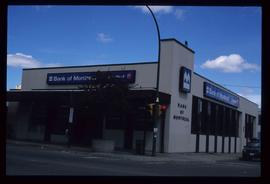
Image depicts the Salvation Army on Ospika Boulevard in Prince George, B.C. Map coordinates 53°55'02.6"N 122°47'41.6"W.
Image depicts Central Street West, parallel to Highway 97 in Prince George, B.C. looking north. Shown: Prince George Motors and other car dealerships, Burger King, Grama's Inn, and the Spruceland Shopping Mall sign. Map coordinates 53°54'42.1"N 122°46'53.1"W
Image depicts the Fraser River and the Yellowhead and Grand Trunk Railway Bridges from LC Gunn Park. Map coordinates 53°54'30.7"N 122°43'27.0"W
Image depicts the Northwood pulpmill in Prince George B.C.
Image depicts the Foothills Bridge over the Nechako river on the Foothills Boulevard in Prince George, B.C. Map coordinates 53°56'52.5"N 122°48'59.9"W
Image depicts the Grand Trunk Railway bridge across the Fraser River. Map coordinates 53°54'29.0"N 122°42'06.5"W
Image depicts Prince George, possibly with the Northwood Pulpmill in the background.
Image depicts the Prince George welcome and population sign, with a population of 71,086. Map coordinates 53°53'52.0"N 122°46'08.7"W
Image depicts Pineview on Buckhorn Lake Road, Prince George, B.C.
Image depicts a snow sculpted fire place and couch on a skating rink, possibly during the Winter City Conference, in Prince George, B.C. Taken at the Prince George Civic Center. Map coordinates 53°54'45.6"N 122°44'59.6"W
Image depicts a snow sculpture of the Mr. P.G. lounging on a couch, possibly during the Winter City Conference, in Prince George, B.C. Taken at the Prince George Civic Center. Map coordinates 53°54'45.6"N 122°44'59.6"W
Image depicts the Northwood Pulpmill in Prince George, B.C. taken from above the Nechako River looking east. Map coordinates 53°56'00.0"N 122°44'29.7"W
Image depicts the intersection of 5th Ave and Highway 97 looking northeast. Map coordinates 53°55'14.0"N 122°46'54.8"W
Image depicts Prince George City Hall. Map coordinates 53°54'46.3"N 122°44'41.9"W
Image depicts a view of Prince George from City Hall looking northeast along George Street. Includes a back view of the Prince George cenotaph. Map coordinates 53°54'46.3"N 122°44'41.9"W
Image depicts the Seymour Subdivision in Prince George, B.C.
Image depicts Prince George, with the picture looking North-Northeast from University Way.
Image depicts Prince George from University Way, with the P.G.I pulp mill in the distance.
Image depicts an old building with a sign labelled "Northern Rooms" in an uncertain location somewhere in Prince George, B.C.
Image depicts the south side of 3rd Ave in Prince George, B.C.
Image depicts the Europe Hotel on the south side of 3rd Ave in Prince George, B.C.
Image depicts the BC Liquor Store in Prince George, B.C.
Image depicts the demolition of the Europe Hotel in Prince George, B.C.
Image depicts a bridge in Prince George, B.C.
Image depicts a house in the process of being demolished in Prince George, B.C.
Image depicts a view of Prince George from an uncertain location.
Image depicts the Lheidli T'enneh Burial Grounds in Fort George Park.
Image depicts an unknown building under construction at the corner of 6th Avenue and Dominion Street in Prince George, B.C.
Image depicts the Bank of Montreal in Prince George, B.C.
Image depicts a few storage sheds somewhere in Prince George, B.C.
Image depicts a street of houses somewhere in Prince George, B.C.
Image depicts a street of businesses, possibly 3rd Avenue, in Prince George, B.C.
Image depicts the interior of the Ginter House in Prince George, B.C.
Image depicts the Ginter House in Prince George, B.C.
Image depicts what is possibly a train fuelling station at the GTP Roundhouse in Prince George, B.C.
Image depicts the Grand Trunk Pacific railway roundhouse in Prince George, B.C.
Image depicts machinery in the GTP roundhouse in Prince George, B.C.
Image depicts the GTP roundhouse in Prince George, B.C.
Image depicts a train in the interior of the GTP roundhouse in Prince George, B.C.
Image depicts the interior of the GTP roundhouse in Prince George, B.C.
Image depicts a number of small houses at Island Cache.
Image depicts two unknown children in a house somewhere in Island Cache.
Image depicts several old, ruined cars and an unknown individual in Island Cache.