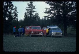
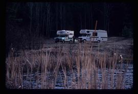
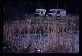
Image depicts a camper on the shore of what is possibly Melita Lake, near the Tseax Cone.
Image depicts the road leading to the historic Hat Creek Ranch site north of Ashcroft, B.C. Several individuals are sitting on the front porch of the Ranch house.
Image depicts an elevated view of a lake and a road located somewhere near Bralorne, B.C.
Image depicts a dirt road leading through a forest with what appears to be an area for turning around at the end.
Image depicts a dirt road leading through a forest.
Image depicts a car on a dirt road leading through a forest.
Image depicts a camper parked on the side of a narrow road along a cliff as another car approaches; located somewhere near Bralorne, B.C.
Image depicts a camper passing under an overhang as it drives along a narrow road near a cliff; located somewhere near Bralorne, B.C.
Image depicts the old, grown-over Cariboo Road at an uncertain location.
Image depicts the Cariboo Road at Hat Creek Ranch, near Highway 99 on the way to Lillooet.
Image depicts the Cariboo Road south of Williams Lake.
Image depicts the old Goat River Train Station in Goat River, B.C.
Image depicts the old Giscome Train Station in Giscome, B.C. It was demolished between 1976 and 1977.
Image depicts a freight wagon in Barkerville.
Image depicts the Cariboo Road passing through the Cottonwood House Historic Site.
Image depicts the CN rail station in Smithers B.C.
Image depicts the CN Rail station located in Kitwanga, B.C.
Image depicts the McBride CNR station.
Image depicts the Kwinitsa CNR station in Kwinitsa, along the Skeena River.
Image depicts the Kwinitsa CNR station, which is Prince Rupert's railway museum.
Image depicts the rail yards in Prince Rupert.
Image depicts a train track and several buildings in an unknown location.
Image depicts a group of people preparing to depart on a trip. Location is uncertain, though it is possibly in Prince George, B.C.
Image depicts a green canoe sitting in the water on the shore of Carp Lake.
Image depicts a building, possibly an office building, next to a set of rail road tracks in Leo Creek, B.C. An unknown individual is present, and a number of barrels and culverts are visible in the foreground.
Image depicts rail road tracks west of Takla Landing.
Image depicts a man standing in front of a helicopter; a waterfall is visible on the cliffs in the background. The slide itself is labelled "BC Parks Tour."
Image depicts the "Divides Lake Waterfall" as well as a man in front of a helicopter in the foreground.
Image depicts the hiking group packing their gear into two vans.
Image depicts two campers at an uncertain location, possibly somewhere near Meldrum Creek, B.C.
Image depicts a camper and a man and woman at an uncertain location, possibly somewhere near Meldrum Creek, B.C. The woman in the image is Sue Sedgwick.
Image depicts a ferry on a river, possibly the Fraser River in the Lillooet area.
Image depicts a red carriage labelled in yellow "B.C. Express Co. No. 20." It is possibly located in Kamloops, B.C.
Image depicts a close-up of the carriage step. It is possibly located in Kamloops, B.C.
Image depicts numerous docked boats in Kitimat, B.C.
Image depicts numerous docked boats, as well as many houses on the shore in the background; located in Kitimat, B.C.
Image depicts a harbour in Kitimat, B.C.
Image depicts a truck parked on the side of the Cassiar Highway.
Image depicts numerous vehicles and individuals outside a hotel in Likely, B.C.
Image depicts a hotel in Likely, B.C.
Image depicts a blue truck and a camper in the wooded area surrounding the townsite of Keithley Creek, B.C.
Image depicts the dirt road leading to Keithley Creek.
Image depicts the townsite of Keithley Creek, B.C.
Image depicts the Fraser River at Paddlewheel park, with a train on the other side of the river, in Prince George B.C.