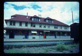
File contains slides depicting images of the Grand Trunk Pacific railway roundhouse in Prince George, B.C.
Image depicts what is possibly a train fuelling station at the GTP Roundhouse in Prince George, B.C.
Image depicts the Grand Trunk Pacific railway roundhouse in Prince George, B.C.
Image depicts machinery in the GTP roundhouse in Prince George, B.C.
Image depicts the GTP roundhouse in Prince George, B.C.
Image depicts a train in the interior of the GTP roundhouse in Prince George, B.C.
Image depicts the interior of the GTP roundhouse in Prince George, B.C.
Image depicts a truck parked on the side of the Cassiar Highway.
Image depicts numerous vehicles in the parking lot of a mall in Mackenzie, B.C.
Image depicts the gas station at Manson Creek, B.C.
Image depicts several ships on the water in Prince Rupert, B.C.
Image depicts a section of road running through the Bear River Gorge.
Image depicts a road and field somewhere near Grassy Plains, B.C.
Image depicts a turbine on the back of an industrial vehicle, located somewhere in Fort St. John, B.C. The slide is labelled "Site one dam; turbine prop. (Russian.)"
Image depicts the CN Station in Dome Creek, B.C.
Image depicts a strangely shaped orange vehicle somewhere in Dome Creek, B.C.
Image depicts Mile "0" of the Alaskan Highway in Dawson Creek, B.C.
Image depicts a tractor with a claw lifting logs at a saw mill in Prince George, B.C.
Image depicts the interior of the ferry at Southbank, B.C.
Image depicts a turbine on the back of an industrial vehicle, located somewhere in Fort St. John, B.C.
Image depicts a camper parked on the shore of Nation Lakes, south of Manson Creek, B.C.
Image depicts the road to Manson Creek, B.C.
Image depicts a helicopter in Germansen Landing, B.C.
Image depicts a man at a campsite somewhere near Murray Ridge.
Image depicts numerous docked boats in Prince Rupert, B.C.
Image depicts a fishing boat on the water somewhere near Prince Rupert, B.C. Only half of its name is visible: "spirit."
Image depicts a large vessel docked in Prince Rupert, B.C. The name on its side is "Star Capella." The slide itself is labelled "superport."
Image depicts what is possibly a train fueling station at the GTP Roundhouse in Prince George, B.C.
Image depicts a train in the GTP roundhouse in Prince George, B.C.
Image depicts the interior of the GTP roundhouse in Prince George, B.C.
Image depicts the CN rail station in Smithers B.C.
Image depicts two bridges in Telkwa, B.C. One is for trains.
Image depicts a train and a group of unknown individuals at the GTP roundhouse in Prince George, B.C.
Image depicts the Grand Trunk Pacific railway roundhouse in Prince George, B.C.
File consists notes and reproductions relating to the Dunster station and Mcbride station. Includes: "Re: Dunster Station - Grants, etc". typescript letter from Derek Trimmer, Heritage Advisory Committee, to Karen Craigue, Dunster Community Association (21 Apr. 1988) and "Proposal for the Acquisition, Restoration and use of the Dunster C.N.R. Station" typescript document prepared by Heritage Committee of Dunster Community Association (Feb. 1986). Also includes a photograph depicting the Dunster station (1980?).
Image depicts a vehicle on a gravel road somewhere near Tête Jaune Cache, B.C.
Image depicts a group of individuals who appear to be searching through the rocks near a railway track. It is possibly part of an educational trip.
Image depicts several unidentified individuals lying on a hill outside what is most likely the W.A.C. Bennett Dam in Hudson's Hope, B.C.
Image depicts the Peace Canyon Dam and generating station under construction on the Peace River.
Image depicts a set of railway tracks, and a building with a sign which reads: "Telegraphs." The location is uncertain, but possibly in the Peace River Region.
Image depicts several apartment buildings and the sign for a Gulf Gas Station in Mackenzie, B.C.
Image depicts a man and his family filling up their truck with gas at Manson Creek, B.C.
Image depicts a rail road bridge located somewhere near Terrace, B.C.
Image depicts a view of what is possibly a shipping yard in Prince Rupert, B.C. The slide is labelled "superport."
Image depicts the ferry to Alaska in the port of Prince Rupert, B.C.
Image depicts numerous boats docked by a buildings identified as the "Prince Rupert Fishermen's Co-operative Association."