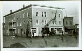
Photograph depicts two connected buildings; the building on the left is possibly the theatre, other building with sign that reads: "The Nechaco (sic?) General Stores." Boardwalk with people and unpaved street in foreground.
Photograph depicts street corner view of Hotel Fort George with people and utility pole in foreground.
Handwritten annotation on verso “Hotel Fort George Central Fort George 1913".
Railroad track, utility poles, field, small building and background hills are visible in image.
Water and dock in foreground, trees and cliffs in background.
Handwritten annotation on verso “’Boat Hammond at South Fort Geroge”.
Unidentified man can be seen walking on railroad tracks on far right. Utility poles, field, small building and background hills are visible in image.
Photograph depicts large crowd gathered in front of three story building.
Printed annotation on recto of photograph: "CARIBOO STAGE AT SOUTH FT. GEORGE B.C. OCT 19 -1911".
Photograph depicts tall building standing alone on street. Stage coach in left foreground, unidentified man in right foreground.
Handwritten annotation on recto: "BANK OF MONTREAL PRINCE GEORGE. B.C. PHOTO. I.B. GUEST.", on verso: “Bank of Montreal, 3rd & Quebec, Prince George. Built in 1919".
Photograph depicts two men standing in front of very small wood building with tarp-covered roof. Chair and paper documents can be seen in front of building, trees and rough cleared land in background.
Handwritten annotation on verso: “The first newspaper office, South Fort George 1910."
Image depicts a view of the Fraser-Nechako confluence from the Prince George cutbanks.
Image depicts a view of Prince George from the cutbanks.
Image depicts a view of Prince George from the cutbanks on the Nechako river.
Image depicts part of the McMillan Creek Trail in the McMillan Regional Park in Prince George, B.C.
Image depicts part of the McMillan Regional Park in Prince George, B.C.
Image depicts the McMillan Creek from Northwood Pulpmill Road, in Prince George, B.C.
Image depicts a farmhouse on Old Summit Road in Prince George, B.C.
Image depicts Prince George at night from the cutbanks.
Image depicts Prince George near the Airport Road.
Image depicts a clearing in Prince George, B.C.
Image depicts the Pearson Homestead.
Image depicts a view of Peden Hill in Prince George, B.C.
Image depicts the Canadian National Railway Yards in Prince George, B.C.
Image depicts a rural setting, most likely near the airport in Prince George, B.C.
Image depicts a few houses, most likely near the airport in Prince George, B.C.
Image depicts Tabor Mountain from the airport in Prince George, B.C.
Image depicts Prince George from the view of Peden Hill.
Image depicts a view of Prince George from Carney Hill.
Image depicts an agricultural field, most likely near Prince George, B.C.
Image depicts power lines east of the pulp mills in Prince George, B.C.
Image depicts natural meadows, possibly east of Prince Georg, B.C.
Image depicts the flows from a pulp mill in Prince George, B.C.
Image depicts an esker at the Foothills Boulevard in Prince George, B.C.
Image depicts an area undergoing logging somewhere in Prince George, B.C.
Image depicts the Tabor Lake Subdivision in Prince George, B.C.
Image depicts the Fraser River from Northwood Road in the Prince George area.
Image depicts a view of Tabor Mountain in Prince George, B.C.
Image depicts the Fraser River from the vantage point of the cutbanks in Prince George, B.C.
Image depicts a view of Prince George, from Gunn Point in the L.C. Gunn Park.
Image depicts a dog and dog house in the back of a pick-up somewhere near Prince George, B.C.
Image depicts a Bavarian style house at College Heights in Prince George, B.C.
Image depicts a Cariboo Ranch style house at College Heights in Prince George, B.C.
Image depicts the balcony of a log house, likely somewhere in or near Prince George B.C.
Image depicts a group of people in Cottonwood Park with an individual, possibly former mayor Elmer Mercier, making an announcement.
Image depicts an aerial view of Fort George Park.
Image depicts a subdivision of Prince George, B.C.
Image depicts trailer homes in Prince George, B.C.
Image depicts a neighbourhood on the Hart Highway in Prince George, B.C.
Image depicts a neighbourhood on North Meadows Road in Prince George, B.C.