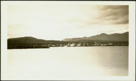
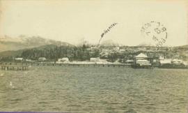
Showing 3218 results

Archival description
2011.3.2.13 · Item · 1921
Part of North Coast & Central BC Postcard Collection

Boardwalk in foreground, buildings and roads in mid ground, cut banks in background. Printed annotation on recto reads: “Prince George. B.C. 1921 by Moore”. Handwritten annotation in ink on verso reads: “The Netchaco river is between the mountain and the city and the C.N.R. runs along the river bank nearest the city. This picture is taken looking north.”

2011.3.1.10 · Item · 1907
Part of North Coast & Central BC Postcard Collection

View of pier, cluster of houses and trees with snow topped mountains in background. Handwritten annotation on verso reads: “Hospital” with an arrow pointing to the building. Postage cancelation stamp on verso reads: "PORT ESSINGTON B.C. JUL 7 07". Handwritten annotation on recto reads: “PORT SIMPSON. Mrs. Noble Port Essington B. C. Hope you are feeling better. I am doing splendidly have not felt so well for years. Dr. advises me to stay at least another month A.W.B.”

2009.7.1.066 · Item · [ca. 1873 - ca. 1920]
Part of Archdeacon W. H. Collison fonds

Photograph depicts buildings along shore; bridge and boardwalk cross forest in right foreground. Hills visible in distance.

Handwritten annotation below image reads: "Port Essington from bridge"; on verso: "Heading or full page Illustration Chapter XXIII No2".

2008.3.3.3.1 · Item · 26 May 1995
Part of Bridget Moran fonds

Photograph depicts road at University of Northern British Columbia. Library building stands in center background. Administration and cafeteria buildings can be seen in left background. Accompanying note from Maureen Faulkner: "Walking up to Canada's newest 'U' - ". Photo believed to have been taken on the day Bridget Moran received an Honourary Law Degree.

2006.45.17 · Item · [ca. 1897]
Part of Historical North Coast Photograph Album

View of town on shore, from above. Boats docked along piers and buildings. Hills visible on either side of water in background.

Handwritten photo captions with arrows pointing to sections of image read: "General Merchandise", "Fort Wrangell Hotel".

2011.3.2.05 · Item · 1913
Part of North Coast & Central BC Postcard Collection

Lofty view of South Fort George, river and treed hills in the background. Printed annotation on verso reads: “South Fort George - 1913.” Handwritten message on recto is addressed to “Ethel M. Heurris Norton Maps Bristol County" reads: "11-1-13 an excellent view of south Fort George taken recently. Power Station at cross near water. This does not give all the south residence view. Population approx 1500”.

2012.13.1.3.166 · Item · May 2001
Part of J. Kent Sedgwick fonds

Image depicts a view of Prince George from City Hall looking northeast along George Street. Includes a back view of the Prince George cenotaph. Map coordinates 53°54'46.3"N 122°44'41.9"W

2006.20.12.45 · Item · [ca. 1940]
Part of Northern BC Archives Historical Photograph Collection

Handwritten photo album caption below this photo reads: "Another view from Tower at Whitehorse." Photograph depicts various unidentified buildings, vehicles, and machinery behind dirt road in mid ground. Power poles in foreground; trees, river, and mountains in background.

Royal Canadian Air Force
View from City Hall
2012.13.1.3.045 · Item · Jan. 1978
Part of J. Kent Sedgwick fonds

Image depicts a view of Prince George from City Hall looking northeast with the pulp mills in the background. Map coordinates 53°54'46.3"N 122°44'41.9"W

Veteran House
2012.13.1.24.36 · Item · 2000
Part of J. Kent Sedgwick fonds

Image depicts a property given to the Veterans of the Second World War, located on the corner of 15th Avenue and Elm Street in Prince George, B.C.

Vanderhoof
2012.13.1.51.017 · Item · May 1972
Part of J. Kent Sedgwick fonds

Image depicts a barn with large, Harvestore Systems. It is possibly located on one of the many farms near Vanderhoof, B.C.

Valemount
2012.13.1.85.25 · Item · [1976?]
Part of J. Kent Sedgwick fonds

Image depicts a view of Valemount, with numerous mountains in the background.

Upper Fraser Road in Winter
2012.13.1.89.016 · Item · Feb. 1973
Part of J. Kent Sedgwick fonds

Image depicts several unidentified individuals walking along the snow-covered Upper Fraser Road with numerous buildings on either side. Map coordinates 54°07'05.7"N 121°56'38.9"W