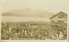
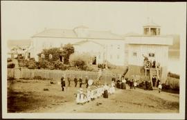
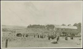
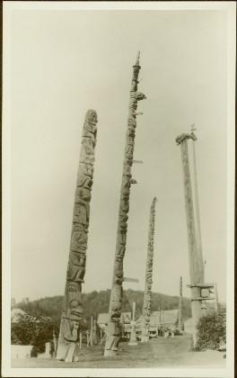
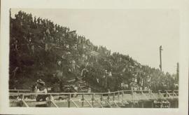
Affichage de 841 résultats

Archival description
Dominion Day celebration 1909
2009.7.1.257 · Pièce · 1 July 1909
Fait partie de Archdeacon W. H. Collison fonds

Photograph of a large crowd in formal wear gathered on a slope. Some spectators can be seen perched atop extremely high poles. Annotation on recto reads: "The Crowd at Prince Rupert's Dominion Day Celebration 1909. Allen Photo 1-7-09."

Street down to the shore
2009.7.1.284 · Pièce · 1907
Fait partie de Archdeacon W. H. Collison fonds

View of the road descending to the waterfront. Buildings and forested area are visible on either side of street. Annotation on recto reads: "Prince Rupert BC. '07."

2009.7.1.035 · Pièce · [ca. 1900]
Fait partie de Archdeacon W. H. Collison fonds

Group poses between two buildings, small dog visible behind. Wood piles and tree stumps can be seen on hill in background.

Handwritten annotation on verso reads: "Metlakatla BC / Back row - W.E. Collison, Fr. Hogan, ?, ? Canon Keen / Front row - ?, ?, Bishop Du Vernet, Archdeacon Laycock". See also item 2009.7.1.32 for image featuring Father Hogan, and 2009.7.1.29 for image featuring Bishop Du Vernet.

St. Andrew's Church in Sandwick, BC
2009.7.1.040 · Pièce · [ca. 1873 - ca. 1920]
Fait partie de Archdeacon W. H. Collison fonds

Church stands behind white fence, road and power lines in foreground.

Handwritten annotation on verso reads: "St. Andrew's Church, Sandwick, [?] Campbell River Rd (Maud Highway) The mother church in the '[?] District'."

View of street in Metlakatla, BC
2009.7.1.054 · Pièce · June 1911
Fait partie de Archdeacon W. H. Collison fonds

Photograph depicts a row of houses and fenced yards on right, separated from more buildings on left by grassy area.

Printed on image: "Metlakahtla Nr. Prince Rupert. Allen Photo June '11"; handwritten annotation on verso reads: "Metlakatla B.C. North West Coast of America / Collison".

Children gathered at Metlakatla Church
2009.7.1.056 · Pièce · [between 1874 and 1901]
Fait partie de Archdeacon W. H. Collison fonds

Several unidentified individuals can be seen on front steps of church and a group of small children in white stand in line below steps. Other community buildings are visible in background, white fence crosses foreground. Photograph depicts the first church built in Metlakatla, which was burned in a fire in 1901, and replaced in 1903.

Handwritten annotation on verso reads: "Church (of England) at Metlakahtla - British Columbia. Built by the people of the village - largest church then on the pacific coast."

Mission hospital in Metlakatla, BC
2009.7.1.060 · Pièce · [ca. 1873 - ca. 1920]
Fait partie de Archdeacon W. H. Collison fonds

Photograph depicts a large two-storey building with the sign: "CALEDONIA HOSPITAL". Fence crosses foreground, hills visible in background.

Handwritten annotation on verso reads: "Mission Hosp at Metlakatla B.C."

2009.7.1.062 · Pièce · [ca. 1873 - ca. 1910]
Fait partie de Archdeacon W. H. Collison fonds

Photograph depicts a group of children dressed in white walking in a line, and adults and other children watching from behind. Group of six man stand in line on left, one holding a flag, another a drum. Jail tower and large building stand behind fence in background.

Handwritten annotation on verso reads: "Old Mission House & jail at Metlakatla Before the fire."

Funeral party on beach at Metlakatla, BC
2009.7.1.063 · Pièce · [ca. 1873 - ca. 1920]
Fait partie de Archdeacon W. H. Collison fonds

Photograph depicts a group of men, women, and children walking across beach towards water. Buildings visible on shore in left background.

Handwritten annotation on verso reads: "Funeral party - en route to boat Metlakatla BC (Taking body over to Grave Island".

Eastern section of Port Simpson, BC
2009.7.1.067 · Pièce · [ca. 1873 - ca. 1920]
Fait partie de Archdeacon W. H. Collison fonds

Photograph depicts town buildings on opposite shore. Beach and dock can be seen in foreground.

Handwritten annotation on verso reads: "Chapter XXII, No 1. Eastern Section of Port Simpson as christianized."

2009.7.1.074 · Pièce · [ca. 1876 - ca. 1900]
Fait partie de Archdeacon W. H. Collison fonds

Photograph depicts many crest poles in front of wooden homes. An unidentified family can be seen sitting by house in centre. Wood pile and path in foreground.

Handwritten annotation on image reads: "Masset Queen Charlotte's Islands, Crest Poles / Masset with Totems."; on verso: "Chap. XIII. No. 1 This photo to be copied as an illustration on 1st page or I Chapt. 'Section of Massett, Haida Encampment showing Totems. Queen Charlotte's Islands.' For heading of page 2 of Trophies."

2009.7.1.092 · Pièce · [ca. 1876 - ca. 1900]
Fait partie de Archdeacon W. H. Collison fonds

Totem poles (crest poles?) stand in front of a line of houses. Blanketed canoes sit on beach in right foreground; forest in background.

Handwritten annotations on verso read: “skidegate village Queen Charlotte Islands as it appeared forty years ago"; "Rev W.E. Collison Prince Rupert"; "Hughes"; "1".

2009.7.1.108 · Pièce · [ca. 1878 - ca. 1915]
Fait partie de Archdeacon W. H. Collison fonds

Chief Gideon stands in suit and tie behind his wife who sits on the ground in front. Fence with chicken wire crosses midground, building visible in background.

Handwritten annotation on verso reads: "Chief Gideon & his wife on upper Nass River".

Mission house in Kincolith, BC
2009.7.1.115 · Pièce · [ca. 1878 - ca. 1919]
Fait partie de Archdeacon W. H. Collison fonds

Photograph depicts tall building, with long shorter section crossing midground in front. Path runs through garden in foreground.

Handwritten annotation on verso reads: "Back of Mission House Kincolith".

2009.7.1.124 · Pièce · [ca. 1880 - ca. 1920]
Fait partie de Archdeacon W. H. Collison fonds

Photograph depicts two unidentified men sitting on front steps of large church. Building materials are scattered in foreground, and scaffolding is visible on one tower.

Handwritten annotations above and below image read: "Dimensions of 73 Feet in length by 37 Feet in width exclusive of Porch and Buttresses. Destroyed by fire with 30 dwelling houses. The spire had been completed when burnt."; "Kincolith Church, Nth. W. Coast. British Columbia within 5 miles of the Alaskan Coast, was destroyed by fire"

2009.7.1.130 · Pièce · [ca. 1878 - ca. 1920]
Fait partie de Archdeacon W. H. Collison fonds

Photograph depicts two men standing beside beds of fish laid out to dry. More oolichan fish hang on tall structures in background.

Handwritten annotation on verso reads: "'Food for winter' Oolichans drying at Fishing Bay, Nass River".

2009.7.1.153 · Pièce · [ca. 1880 - ca. 1915]
Fait partie de Archdeacon W. H. Collison fonds

Group of eight men and seven children stand in front of crest pole on unidentified building.

Handwritten annotation below image reads: "[..?] Alaska. Indian Totem Pole, Eagle Crest South Eastern Alaska."; on verso: "Chapter XXI Illustrations No. 2. [Kinnanook?] Section of Indian Village showing Totem pole of Eagle crest."

View of Wrangell, Alaska
2009.7.1.158 · Pièce · 1877
Fait partie de Archdeacon W. H. Collison fonds

Photograph depicts community buildings on shoreline, water in foreground.

Handwritten annotation on image reads: "Wrangle, Alaska."; on verso: "Fort Wrangle, Alaska Territory. visited by W.H.Collison, C.M.S. 1877. Prior to the establishment of any mission, [...? illegible] 1875 - 1876. Presbyterian. Insert this illustration of Wrangle on Page 77 as marked."

Poling a canoe
2009.7.1.165 · Pièce · [ca. 1910]
Fait partie de Archdeacon W. H. Collison fonds

Three Indigenous men stand in a canoe poling their craft along a shoreline while one man sits and steers. An unidentified village is visible along the opposite shore.

First Nations village at Haida Gwaii
2009.7.1.177 · Pièce · [ca. 1920]
Fait partie de Archdeacon W. H. Collison fonds

Rocky shoreline featuring a small dwelling, totem pole, net rack, canoes pulled up to shore, barrels and boxes and a tent.

Handwritten annotation in pencil on verso reads: “Kunhalas [sic] at entrance to C--- Harbour”.

Giscome Community Hall
2012.13.1.87.160 · Pièce · [between 1975 and 1995]
Fait partie de J. Kent Sedgwick fonds

Image depicts the Giscome Community Hall in Giscome, B.C. Map coordinates 54°04'18.5"N 122°21'57.7"W