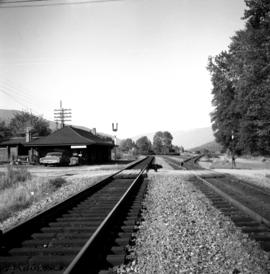
Affichage de 4046 résultats

Archival description
4046 résultats avec objets numériques Afficher les résultats avec des objets numériques
Giscome CN Station
2012.13.1.87.161 · Pièce · [between 1975 and 1995]
Fait partie de J. Kent Sedgwick fonds

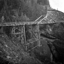
Image depicts the old CN station in Giscome, B.C. Map coordinates 54°04'20.7"N 122°22'01.1"W

Trains at Giscome Mill Site
2012.13.1.87.153 · Pièce · [between 1975 and 1995]
Fait partie de J. Kent Sedgwick fonds

Image depicts several trains at the Giscome mill site in Giscome, B.C. Map coordinates 54°04'19.7"N 122°22'04.7"W

Street in Giscome - After
2012.13.1.87.094 · Pièce · [between 1980 and 2000]
Fait partie de J. Kent Sedgwick fonds

Image depicts a street in Giscome. The store was previously located on the left. The church is in the background. Map coordinates 54°04'18.5"N 122°21'57.7"W

Employee Houses on Giscome Mill Site
2012.13.1.87.088 · Pièce · [between 1980 and 2000]
Fait partie de J. Kent Sedgwick fonds

Image depicts employee houses on mill site in Giscome, B.C. Tug boats are in the foreground on the right. Map coordinates 54°04'23.4"N 122°22'16.9"W

Giscome - Train Tracks - After
2012.13.1.87.087 · Pièce · [between 1975 and 1995]
Fait partie de J. Kent Sedgwick fonds

Image depicts the Giscome mill site in Giscome, B.C. The railroad tracks are in the foreground. Map coordinates 54°04'17.6"N 122°22'06.1"W

Giscome Houses and Railway Tracks
2012.13.1.87.078 · Pièce · [between 1975 and 1995]
Fait partie de J. Kent Sedgwick fonds

Image depicts the Giscome railway station and buildings remaining in townsite in Giscome, B.C. Map coordinates 54°04'18.0"N 122°22'04.7"W

Houses and Train in Giscome
2012.13.1.87.073 · Pièce · [between 1975 and 1995]
Fait partie de J. Kent Sedgwick fonds

Image depicts the Giscome B.C. townsite from across the railroad tracks looking southeast. Map coordinates 54°04'19.7"N 122°22'04.7"W

Upper Fraser Mill
2012.13.1.87.066 · Pièce · [between 1975 and 1995]
Fait partie de J. Kent Sedgwick fonds

Image depicts the Upper Fraser Road running through Upper Fraser, B.C. A newer style round burner is seen in the background. Map coordinates 54°07'05.7"N 121°56'38.9"W

Upper Fraser Mill
2012.13.1.87.063 · Pièce · [between 1975 and 1995]
Fait partie de J. Kent Sedgwick fonds

Image depicts the Upper Fraser mill yard with a CN train in Upper Fraser, B.C. Map coordinates 54°07'10.8"N 121°56'51.7"W

Upper Fraser Mill
2012.13.1.87.062 · Pièce · [between 1975 and 1995]
Fait partie de J. Kent Sedgwick fonds

Image depicts the entrance to the Upper Fraser mill yard in Upper Fraser, B.C. Map coordinates 54°07'10.8"N 121°56'51.7"W

Upper Fraser Mill
2012.13.1.87.061 · Pièce · [between 1975 and 1995]
Fait partie de J. Kent Sedgwick fonds

Image depicts the entrance to the Upper Fraser mill yard in Upper Fraser, B.C. Map coordinates 54°07'10.8"N 121°56'51.7"W

Upper Fraser Road in Upper Fraser, BC
2012.13.1.87.041 · Pièce · [between 1975 and 1995]
Fait partie de J. Kent Sedgwick fonds

Image depicts the Upper Fraser Road running through Upper Fraser, B.C. A beehive burner is seen in the background on the left and the mill office is seen on the right. Map coordinates 54°07'05.7"N 121°56'38.9"W

House in Upper Fraser, BC
2012.13.1.87.042 · Pièce · [between 1975 and 1995]
Fait partie de J. Kent Sedgwick fonds

Image depicts and old house and vehicle in Upper Fraser, B.C. Map coordinates 54°07'05.7"N 121°56'38.9"W

Boat on a Lake
2012.13.1.87.034 · Pièce · [between 1975 and 1995]
Fait partie de J. Kent Sedgwick fonds

Image depicts a riverboat on the Fraser River, possibly in Longworth, B.C.

Dirt Road
2012.13.1.87.025 · Pièce · [between 1975 and 1995]
Fait partie de J. Kent Sedgwick fonds

Image depicts a dirt road leading through numerous trees toward a mountain. The location is uncertain, likely on the way to Longworth, B.C.

Dirt Road
2012.13.1.87.024 · Pièce · [between 1975 and 1995]
Fait partie de J. Kent Sedgwick fonds

Image depicts a dirt road leading through numerous trees toward a mountain. The location is uncertain, likely on the way to Longworth, B.C.

Sinclair Mills Railway Tracks
2012.13.1.87.014 · Pièce · [between 1975 and 1995]
Fait partie de J. Kent Sedgwick fonds

Image depicts railway tracks and buildings with a beehive burner on the left. The location is likely Sinclair Mills, B.C. Map coordinates 54°01'17.4"N 121°40'53.0"W

Logs, Fraser River, and Mountains
2012.13.1.87.013 · Pièce · [between 1975 and 1995]
Fait partie de J. Kent Sedgwick fonds

Image depicts a pile of old logs on the bank of the Fraser River with mountains in the background. In the foreground, a set of railway tracks run through an uncertain location, likely Upper Fraser, B.C.

Hansard Railroad Bridge
2012.13.1.87.003 · Pièce · [between 1975 and 1995]
Fait partie de J. Kent Sedgwick fonds

Image depicts the Hansard railroad bridge looking west. Map coordinates 54°04'37.9"N 121°50'46.3"W

2012.13.1.87.004 · Pièce · [between 1975 and 1995]
Fait partie de J. Kent Sedgwick fonds

Image depicts several eighteen wheelers at the Pass Lake Road and Upper Fraser Road intersection with numerous houses and buildings in the background in McGregor, B.C. Map coordinates 54°04'38.1"N 121°50'00.1"W

Highway 97
2012.13.1.3.164 · Pièce · May 2001
Fait partie de J. Kent Sedgwick fonds

Image depicts a section of Highway 97 looking south. Map coordinates 53°55'10.3"N 122°46'54.9"W

Fifth Avenue Intersection
2012.13.1.3.163 · Pièce · May 2001
Fait partie de J. Kent Sedgwick fonds

Image depicts the intersection of 5th Ave and Highway 97 looking northeast. Map coordinates 53°55'14.0"N 122°46'54.8"W

CN Train Yard
2012.13.1.3.121 · Pièce · 12 Oct. 1989
Fait partie de J. Kent Sedgwick fonds

Image depicts a number of trains in the CNR train yard taken from River Road in Prince George, B.C. Map coordinates 53°54'51.5"N 122°43'29.6"W

CPR depot at Proctor, BC
2013.6.36.1.028.43 · Pièce · 16 Sept. 1970
Fait partie de David Davies Railway Collection

Photograph depicts the CPR depot at Proctor, located at mile 117.5 from Cranbrook on the Nelson Subdivision. David Davies notes: "The view is looking east and shows the spur at right leading to a barge slip on Kootenay Lake. The majority of the spur rails here are dated 1908-1910." An updated description provided by a subject expert suggests that this view is actually looking west.

Water car on the CPR line at Nelson
2013.6.36.1.028.42 · Pièce · 18 Sept. 1970
Fait partie de David Davies Railway Collection

Photograph depicts water car #415319 standing on a little used spur in Nelson. It consists of a locomotive tender mounted on a flat car. It could be used as a firefighting unit, but it is merely lettered "service."

2013.6.36.1.007.048 · Pièce · Oct. 1965
Fait partie de David Davies Railway Collection

Photograph depicts a C.P.R. eastbound freight train at passing loop at Illecillewaet, between Rogers Pass and Revelstoke. The April 25, 1965 CPR Employee timetable lists the mileage at Illecillewaet as 98.2 with a siding capacity of 85 cars. The view in this photograph is taken from a string of work cars on the siding.

2013.6.36.1.007.051 · Pièce · Oct. 1965
Fait partie de David Davies Railway Collection

Photograph depicts the C.P.R. westbound freight train at passing loop at Illecillewaet, between Rogers Pass and Revelstoke. The April 25, 1965 CPR Employee timetable lists the mileage at Illecillewaet as 98.2 with a siding capacity of 85 cars.

Forestry Boat at Giscome Portage, BC
2009.5.3.157 · Pièce · [ca. 1910]
Fait partie de Taylor-Baxter Family Photograph Collection

Photograph depicts men on river boat and small canoe floating just off shore. Men sit and stand on shore among square bales and large cut lumber. Forest in background. Handwritten annotations on recto of photograph: "Fort Fraser wooding up at Giscome Portage", "Chilco at Giscome Portage".

David Davies Railway Collection
2013.6 · Collection · [before 2020]

The David Davies Railway Collection encompasses all facets of railway history specifically in the province of British Columbia and the Yukon territory. The collection consists of research material accumulated over the course of more than fifty years, and includes monographs, periodicals, articles, clippings, railway timetables, photographs, maps and plans, and excerpts. Material covers public, tourist, and private (industrial) railways, including: CPR, KVR, E&N; CNR, CNoR, GTPR; and PGER, BCR. The collection excludes material regarding streetcar systems and rapid transit, but includes long distance electric interurbans.

Boston Bar in the Fraser Canyon
2013.6.36.1.001.94 · Pièce · [May 1966]
Fait partie de David Davies Railway Collection

Photograph depicts the North Bend Ferry (Aerial Cage) at Boston Bar in the Fraser Canyon. The capacity of the aerial cage is 1 car or truck, or 40 passengers. Vehicle height clearance: 12 feet. Load-limit: 3 tons gross. Schedule: On call 24 hours. Rates: Car with driver, 25 cents; truck with driver, 50 cents; passenger, 5 cents.

Bridge over Similkameen River
2013.6.36.1.001.88 · Pièce · [May 1966]
Fait partie de David Davies Railway Collection

Photograph depicts bridge over the Similkameen River between Hedley and Keremeos. The bridge leads to Ashnola and the photograph taken from the northwest looking south.

Bridge over south Thompson River
2013.6.36.1.001.90 · Pièce · [May 1966]
Fait partie de David Davies Railway Collection

Photograph depicts the bridge over the south Thompson River at Squilax where the road connects Squilax Village with a First Nations reservation on the north bank (photo background). The overhead truss in the center span was created to give clearance to paddle sternwheelers.