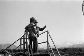
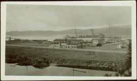
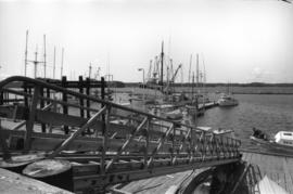
Photograph depicts a ramp and boats at the Prince Rupert marina, including the "Northern Dawn".
Subseries consists of documents and correspondence regarding the Department of Energy, Mines and Resources and issues about mining, energy generation, and pipelines in northern British Columbia. Includes correspondence about the state of energy in Canada; wind, solar, and other forms of alternative energy; conservation of energy; use of nuclear power, coal, oil, and natural gas in Canada; and general inquiries about the oil and gas industry. Also includes correspondence regarding proposed mining projects, particularly in northern BC; the development of pipelines in Canada; the environmental impacts of mining and pipelines; and inquiries and statements of opinion about proposed pipelines such as the Kitimat-Edmonton pipeline, the Mackenzie Delta pipeline, and the Alaska Alcan pipeline. Supplemental records accompany much of the correspondence and include reference material, newspaper articles, and informational reports.
Photo of entire ship building plant, including several vessels in the foreground. Hills are visible in the background. Annotation on recto reads: "Prince Rupert Ship Repair and Ship Building Plant. Prince Rupert BC. Frank E Kirby, William T Donnelly, Engineers. 17 Battery Place. NYC."
Photograph of a half-demolished building attached to a large dock. A large group is milling around the damage. Debris litters the water. Annotation on recto reads: "Undesired result of big blast at Prince Rupert. August 13 1908. Allen Photo."
Wide angle photograph of a crowd milling around railroad tracks. A large pile of rubble and various buildings are visible on the right side. Annotation on recto reads: "After the Blast 21 Jan 1914 McRae Bros Photo."
Photograph of a train traveling through Prince Rupert. Several people are gathered on the dock and around various buildings. Two small vessels are docked in the harbour. Annotation on recto reads: "Prince Rupert, Waterfront. Allen Photo May '4."
This photograph collection consists of 53 photographs featuring primarily Giscome with a few of Prince George. Subjects include the Eagle Lake Sawmill, Eagle Lake, Giscome townsite (including specific buildings and general road perspectives), Giscome School, Division II class photos (1950-51), and the Giscome School teacherage.
Overhead photograph of Giscome with the Eagle Lake Sawmill's beehive burner clearly visible in left foreground. Handwritten annotation in pen on verso reads: “Part of our community. school * ”
Photograph depicts Iona Campagnolo and an unknown man looking over the sawmill owned by Rim Forest Products in Hazelton.
Photograph depicts Iona Campagnolo talking with four unknown men wearing hardhats and standing by vehicles at a sawmill owned by Rim Forest Products in Hazelton.
Photograph depicts Iona Campagnolo speaking with an unknown man wearing a hard hat and holding a package at a sawmill owned by Rim Forest Products in Hazelton.
Photograph depicts a large ship behind dock buildings. Railroad crosses foreground, hills visible on shore in background.
Handwritten annotation on verso reads: "Ship in Pr. Rupert dry dock during Great War 1915?".
Photograph depicts a large ship behind dock buildings. Railroad crosses foreground, hills visible on shore in background.
Handwritten annotation on verso reads: "Pr. Rupert Drydock".
Photograph depicts an empty canoe floating beside a canoe full of fish. Hills visible on opposite shore in distance.
Handwritten annotation on verso reads: "Loaded with fish - Nass River".
Tugboat appears to be towing a long line of small boats.
Handwritten annotation on verso reads: "Fishing fleet coming home Nass River B.C."
Series consists of large format maps and plans relating to railways in British Columbia and Canada. Also includes oversize documents.
Map depicts south eastern British Columbia, with highlighted annotations by Davies to emphasize location of rail lines.
Map depicts railway lines in the state of Washington, including those crossing over the border into British Columbia.
Map depicts the province of British Columbia. Includes rail lines and historical notes about the province.
Map depicts the city of Vancouver and its railways.
Map depicts the CNR system in Canada and the United States and all of its connecting lines, including the Central Vermont Railway, the Grand Trunk Western Railroad, and the Duluth Winnipeg & Pacific Railway.
Map depicts the Cowichan Lake area, including rail trackage for the Western Forest Industries Logging Railway, the Canadian National Railway, and the BC Forest Products Logging Railway.
Architectural block plan depicts a proposed addition to the CNR roundhouse in Kamloops.
Architectural plan depicts a proposed standard 10 stall engine house with annex for machine shop and boiler room to be erected at Kamloops, BC.
Map depicts the cities of Summerland, Penticton, and Naramata. Annotated by Davies to emphasize the rail lines in the area.
Plan depicts a section, profile, and contour plan of the fill of the Lyon Creek Trestle bridge in the Clearwater CNR subdivision.
Plan depicts the location of the Lyon Creek Bridge and borrow pit on the CNR Clearwater subdivision.
Subseries consists of prints and negatives depicting railways in British Columbia, as well as a small selection of other subjects such as historical ships, buildings, vehicles, and bridges. All photographs created by David Davies.
Photograph depicts a small coal tram at Tsable coal pit near Fanny Bay on Vancouver Island.
Photograph depicts a log boom probably in the Lower Mainland or on Vancouver Island.
Photograph depicts dumping logs at Gold River on the west coast of Vancouver Island.
Photograph depicts a baby seal at C.N. log drop at Cowichan Lake on Vancouver Island.
Photograph depicts a lumber mill probably in the Lower Mainland.
Photograph depicts pole climbing in logger sports probably at Squamish, B.C.
Photograph depicts logger sports at Squamish, B.C.
Photograph depicts a logging museum in Ladysmith on Vancouver Island.
Photograph depicts a steam donkey beside a mill pond of a shingle mill at Sappho or Tyee, on the Olympic Peninsula. It is steam fed from the main plant boiler.
Photograph depicts a beehive burner at Brownsville Sawmills Ltd. On Olson St. in south Westminster, Surrey. It is on the banks of the Fraser River just below the Patullo Bridge.
Photograph depicts a small sawmill on the Old Yale Rd., near the intersection of Robson Rd. in South Westminster, Surrey.
Photograph depicts a log on an old trailer bed.
Photograph depicts a general view of the Horne Bros. shingle mill on #305 West Esplanade Rd. in North Vancouver.
Photograph depicts a steam crane in the yard of the Lions Gate Lumber Co. on the foot of Lloyd St. in the North Vancouver. It has been freshly painted with a yellow exterior, white interior, and black boiler.
Photograph depicts a lumber yard on the north side of Porpoise Bay in Sechelt on the Sechelt Peninsula. The tank in the photograph is about 8 to 10 feet in diameter.
Photograph depicts logging on a side road on the Sechelt Peninsula about 2 miles southeast of Halfmoon Bay.
Photograph depicts a mineral ore (lead or zinc?) mines near the ghost town of Sandon, on the road between Kaslo and New Denver.
Photograph depicts Moyie Lake, 15 miles south of Cranbrook, and Moyie Station. The tailings are from a lead and zinc mine directly to the right of the photograph on the hillside. The view is looking north.
Photograph depicts a 10 ton Wallis & Stevens Ltd. #7985 steam roller. It was built at Basingstoke, England from about 1925 to 1927. It is located at 6110 Curtis St. in Burnaby, BC
Photograph depicts the Hedley Gold Mine, 26 miles east of Princeton. Crusher workings.