Showing 2245 results

Archival description
950 results with digital objects Show results with digital objects
2012.13.1.3.168 · Item · Mar. 2003
Part of J. Kent Sedgwick fonds

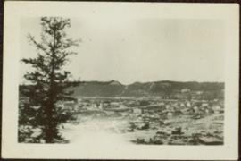
Image depicts an aerial view of a Prince George residential section between Highway 97, Carney Street and 10th Ave looking north. Map coordinates 53°54'54.0"N 122°46'00.4"W

Prince George Sawmill
2012.13.1.3.158 · Item · Nov. 2000
Part of J. Kent Sedgwick fonds

Image depicts Prince George Sawmill taken from across the Nechako River looking southwest. Map coordinates 53°56'00.0"N 122°44'29.7"W

Prince George Sawmill
2012.13.1.3.159 · Item · Nov. 2000
Part of J. Kent Sedgwick fonds

Image depicts Prince George Sawmill taken from across the Nechako River looking southwest. Map coordinates 53°56'00.0"N 122°44'29.7"W

Prince George Sign
2012.13.1.3.139 · Item · 6 Sept. 1993
Part of J. Kent Sedgwick fonds

Image depicts the Prince George welcome and population sign, with a population of 71,086. Map coordinates 53°53'52.0"N 122°46'08.7"W

2012.13.2.18 · Subseries · 1979-2010
Part of J. Kent Sedgwick fonds

Subseries contains material collected and created by Kent Sedgwick for research regarding various areas surrounding Prince George. Includes materials on the Crooked River area; Summit Lake; Ferguson Lake; Chief Lake; Salmon Valley; Mud River; Beaverly; Buckwater; Chilako River; Indian Reserve no. 4; Blackburn; Pineview; Stone Creek; Red Rock; Woodpecker; and Hixon. The files primarily consist of research notes and photographs depicting the communities.

Prince George to Tete Jaune
2011.3.4.14 · Item · [ca. 1901-1915]
Part of North Coast & Central BC Postcard Collection

Stern wheeler in river. Handwritten annotation in pencil on verso reads: “Prince George to Tete Jaune” Hand written message in ink on verso is addressed to “Mademoiselle Elisabeth Joliet, Terrguy – Les Dijore Cote a Or France”

2006.5 · Fonds · 1972 - 1996

Collection consists of records created, received, and collected by the Prince George Women's Centre, the Prince George Women's Collective, the Prince George Women's Equal Rights Association, the Prince George Women's Resource Centre, and the Prince George Women's Connection. This collection also features some materials on the Daughters of Lilith organization.

Prince George Women's Organizations
1994.1.1.5.2.353 · Item · 2005
Part of UNBC Office of External Relations

Videotape contains footage of: 11-May-05 - Prince Rupert - harbour cruise II / 12-May-05 - Prince Rupert - shots of Ridley Island terminals / 12-May-05 - Prince Rupert - oil and gas research reports / 13-May-05 - Prince Rupert - resource communities in transition course - Summerville, Tracy / 14-May-05 - Prince Rupert - city shots including statue of Charles Hays

2000.13.1.115.1 · Item · 1958.
Part of Ray Williston fonds

Item is a photograph of Princess Margaret arriving by Canadian Air Forces jet at Prince George. Lieutenant-Governor Frank Ross is walking beside the Princess.

Originally mounted on a poster with photographs 115, 115.2, 115.3.

2000.13.1.115.2 · Item · 1958.
Part of Ray Williston fonds

Item is a photograph of Princess Margaret arriving by Canadian Air Forces jet at Prince George. Lieutenant-Governor Frank Ross is walking beside the Princess.

Originally mounted on a poster with photographs 115, 115.2, 115.3.

Princess Margaret on a train
2000.13.1.115.3 · Item · 1958.
Part of Ray Williston fonds

Item is a photograph of Princess Margaret on the back deck of the Royal train's caboose just prior to her departure from Prince George during her 1958 visit to British Columbia.

Originally mounted on a poster with photographs 115, 115.2, 115.3.

2000.13.1.25 · Item · 1958
Part of Ray Williston fonds

Item is a photograph of Princess Margaret on July 17, 1958 at an event staged in the Prince George railway yards. Alex Moffat dressed as a prospector demonstrates panning for previously salted gold nuggets, which were later given to the Princess.

Private rail/road bridge
2013.6.36.1.153.04 · Item · [June 1996]
Part of David Davies Railway Collection

Photograph depicts a private rail/road bridge built to serve Northwood Pulp and Timber, Ltd. Crossing Fraser River. Looking west, towards the mill. On private Northwood trackage.

2012.13.2.21.01 · File · 1983-1991
Part of J. Kent Sedgwick fonds

File consists of records created or collected by Kent Sedgwick relating to various community projects associated with river parks. Example projects included in the file are a proposed Carrier village at Hudson Bay Slough, a Cottonwood Island park, proposed commercial boat tours on the Nechako and Fraser River, and the Quesnel Paddlewheel Park. Includes a project proposal document by the Fort George Band entitled "Establishing a Permanent Carrier Village in Prince George" (1990); a 1991 meeting package of the Nechako and Fraser River Valleys Committee (regarding the Cottonwood Island property and development of the Heritage River Trails System); a 1991 memorandum entitled "Prince George River Runners - Proposed commercial boat tours on the Nechako and Fraser River"; a 1983 "Submission to Rivers Committee Public Hearings by Heritage Advisory Committee, City of Prince George" describing the various river-adjacent heritage sites in Prince George; and documentation from the Quesnel Paddlewheel Association.

Prominent Figures
2012.13.2.10 · Subseries · 1970-2010
Part of J. Kent Sedgwick fonds

Subseries consists of materials collected and created by Kent Sedgwick for research on prominent individuals within Prince George and northern/central British Columbia. These individuals include various photographers, John Warren Meyer, Fannie Kinney, Father Adrien Morice, Henry Spencer Palmer, and Bridget Moran. The files also contain various other obituaries and materials regarding prominent individuals in Prince George.

2009.6.13.45.27 · Item · [between 1974 and 1979]
Part of The Honourable Iona Campagnolo fonds

Promotional map of Prince George includes an annotated line drawn down the Nechako River, along Central st., 5th Avenue, Carney St., 15th Avenue, and Highway 16, which can be assumed to be the electoral district line. Annotations in pen note the electoral districts of "Fort Nelson-Peace River" and "Prince George-Bulkley Valley".

2009.6.13.45.04 · Item · [between 1974 and 1979]
Part of The Honourable Iona Campagnolo fonds

Map depicts the proposed electoral districts of British Columbia, including: Burnaby, Capilano, Cariboo-Chilcotin, Comox-Powell River, Cowichan-Malahat-The Islands, Esquimalt-Saanich, Fort Nelson-Peace River, Fraser Valley East, Fraser Valley West, Kamloops-Shuswap, Kootenay East, Kootenay West, Mission-Port Moody, Nanaimo-Alberni, New Westminster-Coquitlam, North Vancouver-Burnaby, Okanagan North, Okanagan-Similkameen, Prince George-Bulkley Valley, Richmond-South Delta, Skeena, Surrey-White Rock-North Delta, Vancouver Centre, Vancouver East, Vancouver Kingsway, Vancouver Quadra, Vancouver South, and Victoria.

1994.1.1.5.2.323 · Item · 2004
Part of UNBC Office of External Relations

Videotape contains footage of: 21-Jan-04 - Prototypical Week students attend class at UNBC - DeSousa, Natasha (Kitimat) / 22-Jan-04 - Northern Health Sciences Centre construction - medical building / 10-Feb-04 - NUGSS students on prospect of rising tuition - Sweet, Tamara / 10-Feb-04 - Winter campus shots / 12-Feb-04 - English professor launches online literary journal - Horne, Dee

Publications
1994.1.1.4 · Series · [after 1990]
Part of UNBC Office of External Relations

Series consists of pamphlets, posters, guides, reports, and other publications created by the UNBC Office of Communications.

Publications
1994.1.2.3 · Series · [after 1990]
Part of UNBC Office of External Relations

Series consists of brochures, reports, and other publications collected or created by the UNBC Office of Development.