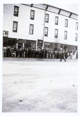
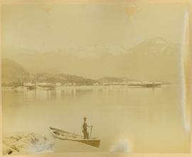
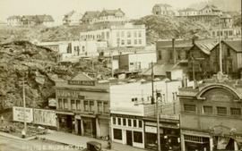
Postcard overview of several identifiable storefronts built amongst the rocky outcrops of Prince Rupert. Printed annotation on recto reads: "Prince Rupert BC."
Postcard overview of the Bulkley River running closely past the village of Telkwa. Handwritten annotation in pen on verso reads: "Don Choracy [?] Prince Rupert, B.C. c/o Wrathall's Photo Shop. Aug. 9 Lake Kaetlyn. We had to drive all the way to Telkwa the other nite for postcards, imagine. We were sure glad and surprised to see Jack & Dick drive in at 7 to-nite. Just like being home. We are having so much fun. The boys are out on Lake to-nite, went to visit Dr. Macdonald's me thinks. I have bad head cold so have to stay home first nite at home I've since we came, Dieks is taking me on Lake tomorrow I hope, Love Bea-P."
Photograph features a sign in the middle of a field at the Royal Canadian Air Force base in Whitehorse, YT that reads: "Taking Photographs Prohibited". Handwritten photo album caption below this photo reads: "Our Authority". See also items 2006.20.12.39 & 2006.20.12.43.
Sem títuloPhotograph depicts three men (two in uniform) in front of a military plane with the number "7632" on its side. Handwritten photo album caption below this photo reads: "OUR CENIAL CREW OF "32". It is believed this photograph was taken at the military base in Whitehorse, YT.
Sem títuloPhotograph depicts military plane landed in Grande Prairie airstrip. One man is semi-visible behind left wing. Land rollers, other unidentified equipment, and flat horizon in background. Handwritten photo album caption beside this photo reads: "32".
Sem títuloPhotograph depicts group of buildings at Grande Prairie airstrip. The foremost building has the sign "YUKON SOUTHERN" on its roof, and the tower and admin building can be seen behind. Power poles, large trucks, and other large unidentified machinery are lined up in background on right.
Sem títuloPhotograph depicts man in uniform reclining on the ground against what appears to be the tarp of a tent, with eyes closed and bottled beverage in hand. A second man is semi-visible in background behind tent. Handwritten photo album caption above and below this photo reads: "Our Cpt, Dreaming of his Third Stripe."
Sem títuloHandwritten photo album caption below this photo reads: “Ready for Work”. Photograph depicts two unidentified men in uniform, standing in front of military plane with the number "...53" on its side. Luggage in foreground, including two suitcases with red cross symbol on side.
Sem títuloHandwritten photo album caption below this photo reads: "Scene on the Apron, 'Any Day' Fort Nelson, Our 'Lodestar' in the foreground." Photograph depicts three planes on apron, surrounded by various unidentified men and trucks. Pavement in foreground, trees in background.
Sem títuloHandwritten photo album caption below this photo reads: "Waiting for the Plane at 'Watson'" Photograph depicts unidentified man standing on ice and holding a fish. The ice in the area behind him has been broken, creating a small pond in the frozen lake. Second man sitting behind pond area. Trees on opposite shore in background.
Sem títuloHandwritten photo album caption below this photo reads: "Above the Rockies at 12 000 feet." Photograph depicts the Rocky Mountains from a distance. As the photograph was taken from the inside of an airplane, the plane's wing tip can be seen on the far right of the image. A sun circle is also visible in the top center.
Sem títuloHandwritten photo album caption below this photo reads: "The above ship, after 'doing' a barrel-roll 50 feet above the runway." Photograph depicts three men in uniform bent over wreckage of plane crash in airstrip believed to be at Whitehorse, YT. Large group of men and vehicles in background on right, trees and hillside in background on left.
Sem títuloHandwritten photo album caption below this photo reads: "Barracks at Watson Lake". Photograph depicts long building built in U shape. Wood piles and miscellaneous items can be seen in foreground.
Sem títuloPhotograph depicts baseball game, batter in mid-swing,and buildings visible in background. Handwritten annotation on recto of mounted slide reads: "Base ball game in Lejac". See also items 2006.20.1.199 - 2006.20.1.202 for images featuring similar content.
Photograph depicts a game of horseshoes in foreground. Fence crosses midground in front of water, and hills can be seen on opposite shore in background. Handwritten annotation on recto of mounted slide reads: "Playing horse [shoes?] in Legac".
Photograph depicts two boys standing on platform extending into lake. Buildings and fenced areas can be seen on shore in background. Handwritten annotation on recto of mounted slide reads: "boys playing on the lake / Legac".
Group stands in foreground on what appears to be a wooden teeter totter. Fence crosses midground in front of water, and hills can be seen on opposite shore in background. Handwritten annotation on recto of mounted slide reads: "play ground in Legak [sic]".
Paddlewheeler
Japanese (?) Man standing in a canoe
Photograph depicts glacier in valley below mountains. Handwritten annotation on negative: "K. Glacier [...illegible]".
Image is one of 65 photos documenting a survey of the Canada-Alaska Boundary, Taku River area, May 23 to Oct. 15, 1906.
This particular photo is one of 13 found in original enclosure with the following handwritten annotation: "Kopoka River - river scenes Aug 29 to Oct. 9 [19]06". See also items 2006.20.3.1 - 2006.20.3.13.
Photograph depicts tent among trees, hills visible in background.
Image is one of 65 photos documenting a survey of the Canada-Alaska Boundary, Taku River area, May 23 to Oct. 15, 1906.
This particular photo is one of 13 found in original enclosure with the following handwritten annotation: "Kopoka River - river scenes Aug 29 to Oct. 9 [19]06". See also items 2006.20.3.1 - 2006.20.3.13.
Photograph depicts river and rocky shores, glacier visible on mountain in background. Handwritten annotation on negative: "Glacier [?] Kopoka".
Image is one of 65 photos documenting a survey of the Canada-Alaska Boundary, Taku River area, May 23 to Oct. 15, 1906.
This particular photo is one of 13 found in original enclosure with the following handwritten annotation: "Kopoka River - river scenes Aug 29 to Oct. 9 [19]06". See also items 2006.20.3.1 - 2006.20.3.13.
Photograph depicts two unidentified men standing and sitting at campfire by large fallen trees. Forest and mountains in background. Handwritten annotation on negative: "[?] Taken Near Kopoka".
Image is one of 65 photos documenting a survey of the Canada-Alaska Boundary, Taku River area, May 23 to Oct. 15, 1906.
This particular photo is one of 8 found in original enclosure with the following handwritten annotation: "From main camp up Kopoka River. Scenes with persons in." See also items 2006.20.3.14 - 2006.20.3.21.
Photograph depicts unknown man standing in water while pulling loaded canoe by rope. Rocky shore in foreground, mountains in background. Handwritten annotation visible on negative: "[?] hauling canoe. Big [?], Kopoka".
Image is one of 65 photos documenting a survey of the Canada-Alaska Boundary, Taku River area, May 23 to Oct. 15, 1906.
This particular photo is one of 8 found in original enclosure with the following handwritten annotation: "From main camp up Kopoka River. Scenes with persons in." See also items 2006.20.3.14 - 2006.20.3.21.
Photograph depicts three unknown men standing in water while pulling loaded canoe by rope. Rocky shore and hills in background. Illegible handwritten annotation visible on negative: "...[K. River]?" (Kopoka?)
Image is one of 65 photos documenting a survey of the Canada-Alaska Boundary, Taku River area, May 23 to Oct. 15, 1906.
This particular photo is one of 8 found in original enclosure with the following handwritten annotation: "From main camp up Kopoka River. Scenes with persons in." See also items 2006.20.3.14 - 2006.20.3.20.
Photograph depicts man [Gilroy?] sitting with small tin cup. Canoe lies upside down in foreground. Water and opposite shore visible in background. Handwritten annotation visible on negative: "Camp. [Gilroy?] on way up from trail. 9 pm".
Image is one of 65 photos documenting a survey of the Canada-Alaska Boundary, Taku River area, May 23 to Oct. 15, 1906.
This particular photo is one of 13 found in original enclosure with the following handwritten annotation: "SOME OTHERS." See also items 2006.20.3.22 - 2006.20.3.34.
Photograph depicts two unidentified men standing to right of flag mounted in rock pile.
Image is one of 65 photos documenting a survey of the Canada-Alaska Boundary, Taku River area, May 23 to Oct. 15, 1906.
This particular photo is one of 13 found in original enclosure with the following handwritten annotation: "SOME OTHERS." See also items 2006.20.3.22 - 2006.20.3.34.
Photograph depicts unknown men standing with walking sticks, carrying large bundles on their backs. Water and opposite shore in background, mountains visible in distance. Handwritten annotation visible on negative: "Billy [Gilroy?] & [?] packed for [?]".
Image is one of 65 photos documenting a survey of the Canada-Alaska Boundary, Taku River area, May 23 to Oct. 15, 1906.
This particular photo is one of 13 found in original enclosure with the following handwritten annotation: "SOME OTHERS." See also items 2006.20.3.22 - 2006.20.3.34.
Photograph depicts two men standing on mountain with walking sticks, carrying bundles on their backs. Valley and mountains visible in background below. Handwritten annotation visible on negative: "[?] Climbing [?] Sta - K. River" (Kopoka?).
Image is one of 65 photos documenting a survey of the Canada-Alaska Boundary, Taku River area, May 23 to Oct. 15, 1906. This particular photo is one of 7 found in original enclosure with the following handwritten annotation: "Around River Taku and main camp on same." See also items 2006.20.3.35 - 2006.20.3.41.
Icebergs can be seen in foreground, opposite shore crosses midground, mountains stand in background.
Image is one of 65 photos documenting a survey of the Canada-Alaska Boundary, Taku River area, May 23 to Oct. 15, 1906. This particular photo is one of 7 found in original enclosure with the following handwritten annotation: "Around River Taku and main camp on same." See also items 2006.20.3.35 - 2006.20.3.41.
Water spans foreground, trees on shore can be seen on far left, mountains stand in background.
Image is one of 65 photos documenting a survey of the Canada-Alaska Boundary, Taku River area, May 23 to Oct. 15, 1906. This particular photo is one of 7 found in original enclosure with the following handwritten annotation: "Around River Taku and main camp on same." See also items 2006.20.3.35 - 2006.20.3.40.
View of snowy mountain range.
Image is one of 65 photos documenting a survey of the Canada-Alaska Boundary, Taku River area, May 23 to Oct. 15, 1906. This particular photo is one of 5 found in original enclosure with the following handwritten annotation: "Boundary No.2 camera Sta. Twin Lake & Glacier.” See also items 2006.20.3.43 - 2006.20.3.46.
Water spans foreground, cliffs cross midground, mountains stand in background.
Image is one of 65 photos documenting a survey of the Canada-Alaska Boundary, Taku River area, May 23 to Oct. 15, 1906. This particular photo is one of 5 found in original enclosure with the following handwritten annotation: "Boundary No.2 camera Sta. Twin Lake & Glacier.” See also items 2006.20.3.42 - 2006.20.3.46.
Photograph depicts mountain range, river or glacier visible below.
Image is one of 65 photos documenting a survey of the Canada-Alaska Boundary, Taku River area, May 23 to Oct. 15, 1906. This particular photo is one of 10 found in original enclosure with the following handwritten annotation: "From [Wahut?]-Azmuth and Koshu.” See also items 2006.20.3.47 - 2006.20.3.56.
Photograph depicts small tent set up in bushes, fallen trees in foreground.
Image is one of 65 photos documenting a survey of the Canada-Alaska Boundary, Taku River area, May 23 to Oct. 15, 1906. This particular photo is one of 10 found in original enclosure with the following handwritten annotation: "From [Wahut?]-Azmuth and Koshu.” See also items 2006.20.3.47 - 2006.20.3.56.
Photograph depicts river or glacier in valley bellow mountains. Handwritten annotation visible on negative: "From No. 2 Cam. Sta. [?] Taku River [?]".
Image is one of 65 photos documenting a survey of the Canada-Alaska Boundary, Taku River area, May 23 to Oct. 15, 1906. This particular photo is one of 10 found in original enclosure with the following handwritten annotation: "From [Wahut?]-Azmuth and Koshu.” See also items 2006.20.3.47 - 2006.20.3.56.
Photograph depicts river or glacier in valley bellow mountains, flat snowy area in foreground.
Image is one of 65 photos documenting a survey of the Canada-Alaska Boundary, Taku River area, May 23 to Oct. 15, 1906. This particular photo is one of 10 found in original enclosure with the following handwritten annotation: "From [Wahut?]-Azmuth and Koshu.” See also items 2006.20.3.47 - 2006.20.3.56.
Photograph depicts group of six men standing and sitting in forest in front of tent structure with log base. Handwritten annotation visible on negative: "[Myself?] Main Camp".
Image is one of 65 photos documenting a survey of the Canada-Alaska Boundary, Taku River area, May 23 to Oct. 15, 1906. This particular photo is one of 9 found in original enclosure with the following handwritten annotation: "Pictures of different members of ‘our’ party.” See also items 2006.20.3.57 - 2006.20.3.65.
Photo description on accompanying photo album page: " 'Yonge Street' at Teslin Lake, Yukon. The centre tent was used by the radio men. Teslin, 130 miles south of Whitehorse, is the site of one of the aircraft radio stations on the new Edmonton-Whitehorse circuit, paralleling the Alaska Highway."
Photograph depicts men on sternwheeler in river, opposite shore in background.
Printed annotation on recto reads: “S.S. “Charlotte,” Quesnel. B.C.” Handwritten message on verso is addressed to “Mr. O. Winter 1016 V Park St. Victoria B.C.” Cancellation stamp on Canadian 1 cent stamp reads: "ASHCROFT B.C. JUN [10?] 11".
Photograph features paddle of sternwheeler with the word "CONVEYOR" visible above paddle. Snow on ground, forest on hill in background.
Handwritten annotation on verso in pencil reads: “Tete Jaune B.C.”
Postcard photograph depicts sternwheeler in river, trees on opposite shore in background.
Printed annotation on recto reads: “Operator 1913, Prince George, B.C. Canada”, handwritten in pencil on verso: “Operator 1913”.
View of snow capped mountains in the distance, vast rolling treed hills in mid ground and a gravel road in the foreground. Road sign indicating severe curve in road situated at the right of the gravel road. Handwritten annotation on verso in pen reads: “Cassiar – Stewart highway”
Five logging trucks parked side by side, their drivers standing beside them. Handwritten annotation on bottom recto of photograph: "Logging Trucks - Halfway River, B.C. 1936".
Overview of Giscome, BC showing built and natural landscape.
Handwritten annotation in pencil on verso: "Bunkhouse & Dining Room / Giscome BC".
Handwritten annotation in pencil on verso: "Daily Capacity 100,000 f.b.m. sawmill in foreground planer mill and lumber yard in background.”