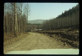
Image depicts a van on a narrow road, likely the Kettle Valley Trail.
Image depicts an unknown figure standing inside a tunnel from the old Kettle Valley Rail Road.
Image depicts the old Kettle Valley Rail Road.
Image depicts a tunnel from the old Kettle Valley Rail Road.
Image depicts a woman standing inside a tunnel from the old Kettle Valley Rail Road.
Image depicts several unknown individuals standing on the old Kettle Valley Rail Road.
Image depicts the Okanagan Kettle Valley, with the Kettle Rail Road faintly visible among the trees
Image depicts the trail of the old Kettle Valley Rail Road.
Image depicts a woman standing inside a tunnel from the old Kettle Valley Rail Road.
Image depicts the mouth of a tunnel from the Kettle Valley Rail Road.
Image depicts a woman standing on the old Kettle Valley Rail Road.
Image depicts several boats on what appears to be a river, and an old beehive burner in Penny, B.C.
Image depicts the CN Station in Penny B.C.
Image depicts the CN Station in Penny B.C. A woman, possibly Sue Sedgwick, is sitting against the outside wall.
Image depicts the CN Station in Penny B.C.
Image depicts the "Divides Lake Waterfall" as well as a man in front of a helicopter in the foreground.
Image depicts a man standing in front of a helicopter; a waterfall is visible on the cliffs in the background. The slide itself is labelled "BC Parks Tour."
Image depicts a number of trains in the CNR train yard taken from River Road in Prince George, B.C. Map coordinates 53°54'51.5"N 122°43'29.6"W
Image depicts the Kwinitsa CNR station in Kwinitsa, along the Skeena River.
Image depicts the Kwinitsa CNR station, which is Prince Rupert's railway museum.
Image depicts a ferry on a river, possibly the Fraser River in the Lillooet area.
Image depicts a close-up of the carriage step. It is possibly located in Kamloops, B.C.
Image depicts the McBride CNR station.
Image depicts a red carriage labelled in yellow "B.C. Express Co. No. 20." It is possibly located in Kamloops, B.C.
Image depicts the road leading to the historic Hat Creek Ranch site north of Ashcroft, B.C. Several individuals are sitting on the front porch of the Ranch house.
Image depicts the McBride CNR station.
Image depicts a ferry entering Horseshoe Bay in the Howe Sound region.
Image depicts two campers at an uncertain location, possibly somewhere near Meldrum Creek, B.C.
Image depicts a camper and a man and woman at an uncertain location, possibly somewhere near Meldrum Creek, B.C. The woman in the image is Sue Sedgwick.
Image depicts the W.A.C. Bennett Dam on the Peace River in Hudson's Hope, B.C.
Image depicts two trains in Prince George, B.C.
Image depicts a road somewhere in Tumbler Ridge, B.C. There are three bush planes in the image.
Image depicts numerous campers and other vehicles in Tumbler Ridge, B.C.
Image depicts a road somewhere in Tumbler Ridge, B.C. There are numerous construction vehicles present.
Image depicts numerous campers and other vehicles in Tumbler Ridge, B.C.
Image depicts a camper on the shore of what is possibly Melita Lake, near the Tseax Cone.
Image depicts several individuals seated on a ferry as it possibly departs from a dock somewhere in Prince Rupert, B.C. It is most likely headed for Haida Gwaii, B.C.
Image depicts numerous boats docked by the Prince Rupert Fishermen's Co-operative Association from the deck of a ferry, possibly as it's leaving Prince Rupert, most likely for Haida Gwaii.
Image depicts the train tracks at the old Dunster Station in Dunster, B.C.
Image depicts a man attaching a logging trailer to a crane on a wooden structure to stack the trailer on the truck. A Crestbrook Forest Industries sawmill is located in the background.
Image depicts a logging truck with its trailer being attached on top of it. A Crestbrook Forest Industries sawmill is located in the background.
Image depicts a ferry docked at Haida Gwaii, B.C.
Image depicts a vehicled parked on the side of the road, with a view of the coast of Haida Gwaii in the background.
Image depicts a harbour in Kitimat, B.C.
Image depicts numerous vehicles and individuals outside a hotel in Likely, B.C.
Image depicts the townsite of Keithley Creek, B.C.
Image depicts a view of Giscome with a train passing through.
Image depicts numerous docked boats, as well as many houses on the shore in the background; located in Kitimat, B.C.