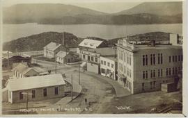
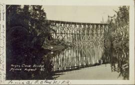
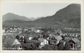
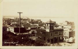
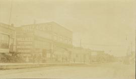
Street view photograph of several commercial buildings on an unidentified dirt road in Prince Rupert, BC. Foreground is primarily a shot of "Wallace's Dry Goods."
Slightly elevated street view of buildings and sidewalks being constructed in Prince Rupert, BC. Printed annotation on recto reads: "Photo by McRae Bros. Third Ave Prince Rupert, BC." Handwritten annotation on verso reads: "Dear Florence you better [illegible] will try and answer it in a few day I am well I will try and send you some cards I will stay here till in Dec Write[??] me and send me some cards I am 15 mile in the mountains Write your Bro LS Bill." Postcard is addressed to: "Miss Florence Wilson P.O. Box 1178 Worcester Mass U.S.A." A 2 cent Canadian stamp is affixed on verso. Postmark reads: "Prince Rupert BC Jul 1 10."
Elevated street view of Fulton Street in Prince Rupert, BC. City Hall is in the left foreground. Hills and water are visible in the background. Printed annotation on recto reads: "Fulton St. Prince Rupert. B.C. W.W.W."
Elevated street view of Fulton Street in Prince Rupert, BC. City Hall is in the left foreground. Hills and water are visible in the background. Printed annotation on recto reads: "Prince Rupert. B.C."
Photograph of a large explosion next to a huge pile of debris. Buildings are visible on either side and railroad track can be seen in the foreground. Printed annotation on recto reads: "The Last Big Blast, Prince Rupert BC 21 Jan 1914 McRae Bros. Photo"
Photograph of a large explosion on a rocky shoreline. A bridge is visible in the foreground and a body of water is partially visible in the background. Printed annotation on recto reads: "McRae Bros Moving Mountains at Prince Rupert BC Apr 24th" Handwritten annotation on verso reads: "Rupert. July 17 1913. Dear [illegible]. Just a card for that album if you've got any room left by now. This is one of the blasts for the clearing of the drydock up here. [Illegible] W.M." Postcard is addressed to: "Miss C.M. Ranip[??] 931 Northlane Av.[sic] Seattle Wash." Two Canadian one cent stamps are affixed on verso. Postmark reads: "Prince Rupert BC. PM Jul 17 13."
Photograph of a large explosion on what appears to be a shoreline. Printed annotation on recto reads: "'Big Blast' Prince Rupert. B.C."
Photograph of a bridge along a rocky shoreline. Printed annotation reads: "Colloway Rapids Bridge Prince Rupert Highway W.W.W." Handwritten annotation on verso is heavily obscured by residual album paper and reads: "PO Box 777 Prince Rupert BC. [Illegible] Lal. This[??] is a piece of our new bridge which [obscured] neats our Island with the mainland. We have had picnics on the other side & [illegible] is open for [illegible] to [illegible]ve ours this side of the [obscured] our stuff to the little [obscured] patronize[??]. Mrs. [illegible] are back again in Rupert [obscured] Kamloops office closed down [obscured] was no chance of transfer. Have not."
Dock in foreground, ship in water, mountain in background. Unidentified men partially visible in foreground. Printed annotation on recto reads: “Launching of Canadian Scottis –CGM.M. 5500, ton ship at Prince Rupert B.C.”
Photograph of a large wooden bridge across Hayes Creek, Prince Rupert, BC. Printed annotation on recto reads: "Hayes Creek Bridge Prince Rupert BC." Handwritten annotation on recto reads: "Dear Mary. Why don't you and my letter hyp[illegible] old [illegible] Louisa A./ P.O. Box 32./ P.R." Handwritten address on verso reads: "Miss Mary Wonoghue Prideaux St., Nanaimo. B.C." Postcard is affixed with a one cent Canadian stamp. Postmarks on verso read: "Prince Rupert B.C. PM Jun 18 11." and "Nanaimo B.C. 18 Jun 21 11."
Street view of Third Avenue in Prince Rupert, BC. Several cars are visible parked along the sides of the paved street. Printed annotation on recto reads: "Third Ave. W Prince Rupert- BC."
Overhead view of a residential area in Prince Rupert, BC. Printed annotation on recto reads: "Prince Rupert, BC Photo by J.W."
Overhead view of many commercial buildings in Prince Rupert, BC. Printed annotation reads: "Prince Rupert, BC."
File contains slides depicting places along the Skeena River on the way to Prince Rupert, B.C.
Image depicts Highway 16 en route to Prince Rupert, B.C.
Image depicts the Skeena River alongside Highway 16 en route to Prince Rupert, B.C.
Image depicts the Skeena River somewhere near Prince Rupert, B.C.
Image depicts a road leading to Prince Rupert, B.C.
File contains slides depicting places in and around Prince Rupert, B.C.
Image depicts several ships on the water in Prince Rupert, B.C.
Image depicts a view of Prince Rupert, B.C.
Image depicts a view of the port in Prince Rupert, B.C. The slide is labelled "superport."
Image depicts a view of what is possibly a shipping yard in Prince Rupert, B.C. The slide is labelled "superport."
Image depicts numerous docked boats in Prince Rupert, B.C.
Image depicts the BC Packers Ltd. cannery in Prince Rupert, B.C.
Image depicts numerous houses on the cliff-sides in Prince Rupert, B.C.
Image depicts a view of the downtown core of Prince Rupert, B.C.
Image depicts Metlakatla, located near Prince Rupert, B.C.
Image depicts a fishing boat on the water somewhere near Prince Rupert, B.C. Only half of its name is visible: "spirit."
Image depicts the ferry to Alaska in the port of Prince Rupert, B.C.
Image depicts a large vessel docked in Prince Rupert, B.C. The name on its side is "Star Capella." The slide itself is labelled "superport."
Image depicts a boat docked inside what appears to be a type of boathouse, possibly located in Metlakatla near Prince Rupert, B.C.
Image depicts numerous boats docked by a buildings identified as the "Prince Rupert Fishermen's Co-operative Association."
Image depicts a grain elevator in Prince Rupert, B.C.
Image depicts the Hecate Strait near Prince Rupert, B.C.
Image depicts a dock in Prince Rupert, B.C.
Image depicts numerous docked boats somewhere in Prince Rupert, B.C.
Image depicts a large building with numerous vehicles in the foreground.
Image depicts numerous buildings and a small dock somewhere in Prince Rupert, B.C. One of the buildings is labelled "Fishermen's Supply."
Image depicts a view of Prince Rupert, B.C.
Image depicts the main street of Prince Rupert, B.C.
Image depicts the City Hall of Prince Rupert, B.C.
Image depicts an old building on the main street of Prince Rupert, B.C. Only half of the business name is visible: "Skeena Color [sic]."
Image depicts the Bank of Nova Scotia located on "Besner Block" in Prince Rupert, B.C.
Image depicts the Pride O' the North shopping mall in Prince Rupert, B.C.
Image depicts numerous houses in Prince Rupert, B.C.
Image depicts several houses in Prince Rupert, B.C.