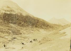
Photograph depicts a pack horse train in the foreground walking through a mountain valley. In the background forested foothills are visible with a mountain peak rising from the background.
Photograph depicts the top of a mountain ridge situated next to an alpine lake. The photograph location is the Mt. Petrie area from the north and northwest.
Handwritten caption below this photo reads: "Finlay River Rapids. - 1930."
A small peninsula extends into river in left midground, rapids in foreground, trees and hills on opposite shore in background.
Close view of bridge built with wooden planks, poles, and wires, braced from below, with triangles built into its frame. The bridge crosses Hagwilget Canyon on the Bulkley River, five kilometres from its confluence with the Skeena River. This is one of the many bridge structures that have crossed this location since at least 1859. Photograph was taken from one side of canyon, near bridge. Opposite canyon wall in background. Typed annotation glued to verso of photograph: "HAGWILGET - 'the gentle or quiet people'."
Photograph depicts two men and a horse on a bridge built with wooden planks, poles, and wires, braced from below, with triangles built into its frame. The bridge crosses Hagwilget Canyon on the Bulkley River, five kilometres from its confluence with the Skeena River. This is one of the many bridge structures that have crossed this location since at least 1859. Photograph was taken from a distance. Rocky riverbank in foreground, opposite shore in background behind bridge. Typed annotation in red ink on verso of photograph: "INDIAN BRIDGE, NEAR HAZELTON, B.C."
Photograph depicts many swallows' nests under eaves of unidentified building, window visible beneath.
Photograph depicts power plant by waterfall. Extensive construction materials and structures can be seen scattered to left of plant. River in foreground, forest and hills in background. Typed annotation on verso of photograph: "Northern B.C. Power Co. Falls River Plant Prince Rupert B.C."
Photograph depicts dry creek bed, tall banks on either side. Hills and lake cross midground, mountains visible in background. Handwritten annotation on verso of photograph: "Looking down McKee Creek across Atlin Lake Towards Taku Glacier 6/27/37."
Photograph depicts the Atlin townsite, forest in foreground, hills in background. Town stands on edge of lake located in left midground. Handwritten annotation on verso of photograph: "Atlin City B.C., Sept. 3rd 1899. Copyrighted by S.A. Smythe Atlin, B.C."
Photograph depicts men and haul trucks visible in distance on snowy road in tree-covered hills.
Photograph depicts an unidentified building in snowy area, trees on hill in background.
Photograph depicts a car, bulldozer, and tractor speculated to be involved in road construction. Rough dirt road runs left of machinery, forest and hills in background.
Photograph depicts lumber and brush piles, forest in background. Crane semi-visible on left, small boat semi-visible on right.
Photograph depicts three men panning in stream, sluiceway behind them. Rocky banks in foreground, forest in background.
Photograph depicts man standing in front of large streams of water spraying from pipe into mining area, hills in background.
Photograph depicts sluice trunk in mining area, men on tall structure in background.
Photograph depicts young fruit trees planted in fenced area with small wind mill, hills in background. Handwritten annotation on recto of photograph: "This is part of the fruit trees if you place it along side of the other one you can see the location the farm buildings are on the other side I didn't get one of them."
Photograph features iceberg floating in water, mountains on shore in background.
Image is one of 65 photos documenting a survey of the Canada-Alaska Boundary, Taku River area, May 23 to Oct. 15, 1906. This particular photo is one of 7 found in original enclosure with the following handwritten annotation: "Around River Taku and main camp on same." See also items 2006.20.3.35 - 2006.20.3.41.
Photograph depicts valley in snowy mountain range. Handwritten annotation visible on negative: "Pan. From Camera Sta no w. looking at [?] Glacier."
Image is one of 65 photos documenting a survey of the Canada-Alaska Boundary, Taku River area, May 23 to Oct. 15, 1906. This particular photo is one of 5 found in original enclosure with the following handwritten annotation: "Boundary No.2 camera Sta. Twin Lake & Glacier.” See also items 2006.20.3.42 - 2006.20.3.46.
Water spans foreground, trees can be seen in water, trunks submerged. Opposite shore and mountains in background.
Image is one of 65 photos documenting a survey of the Canada-Alaska Boundary, Taku River area, May 23 to Oct. 15, 1906. This particular photo is one of 5 found in original enclosure with the following handwritten annotation: "Boundary No.2 camera Sta. Twin Lake & Glacier.” See also items 2006.20.3.42 - 2006.20.3.45.
Water spans foreground, mountains of opposite shore stand in background.
Image is one of 65 photos documenting a survey of the Canada-Alaska Boundary, Taku River area, May 23 to Oct. 15, 1906. This particular photo is one of 10 found in original enclosure with the following handwritten annotation: "From [Wahut?]-Azmuth and Koshu.” See also items 2006.20.3.47 - 2006.20.3.56.
River flows through rocky area, mountains visible in background.
Image is one of 65 photos documenting a survey of the Canada-Alaska Boundary, Taku River area, May 23 to Oct. 15, 1906. This particular photo is one of 9 found in original enclosure with the following handwritten annotation: "Pictures of different members of ‘our’ party.” See also items 2006.20.3.58 - 2006.20.3.65.
Man driving a two horse cart in front of beehive burner, cart is full of bark presumably sawed off the logs.
Handwritten annotation in pencil on verso: "Mill Burner".
Six men visible on hillside and wood plank roadway, working together to roll cut logs down the hill and load them onto the truck.
Handwritten annotation in pencil on verso read: “logs up to 32 feet in length.”
Fully loaded logging truck driving along a switchback, wood plank logging road.
Handwritten annotation in pencil on verso reads: “Truck Logging / Giscome BC.”
Fully loaded logging truck driving along a wood plank logging road. Another road under construction is also visible through forest in background.
Handwritten caption beside this photo reads: "Cookhouse in Winter". Photograph depicts top of building semi-visible behind large snow pile. Treetops can be seen in background.
Handwritten caption beside this photo reads: "Cutting Fire Wood". Photograph depicts two men on either side of large log using chain saw in wood clearing. A small snow-covered building can be seen in background.
Photograph depicts the excavation area in forest where dragline cranes had been operating.
Photograph depicts the load and main hook block of a dragline crane operating in excavation area of forest.
Handwritten caption beside this photo reads: "Fred Youngstron [sic?]" "Foreman spotting for operator." Photograph depicts one man seated on D8 Caterpillar operating a haulback rig, and a second man (Fred?) standing behind him on Caterpillar. Image quality is poor and faces are not visible. Dirt and debris in foreground, forest in background. It is believed this rig is operating in a long-line skidding system.
Handwritten caption beside this photo reads: "Earth Cut". Photograph depicts a man in distance at top of steep slope of man-made embankment, trees in background. Tracks made my machinery are visible in dirt of the cut.
Handwritten caption above this photo reads: "Earth Cut". Photograph depicts the steep slope of man-made embankment, trees in background. Tracks made my machinery are visible in dirt of the cut.
Photograph depicts a close-up view of a snake.
Photograph depicts a baby seal at C.N. log drop at Cowichan Lake on Vancouver Island.
Photograph depicts a dogwood tree in front of the garden at 1057 Beach Ave. in Vancouver. The photo is taken looking northeast.
Photograph depicts a view of Indian Arm, looking south from Granite Falls.
Five woman and one young girl pose on grass in front of palm trees.
Group of seven men and women stands in front of car in dirt road, forest in background. Sarah Glassey stands on far left. Similar group also featured in items 2009.5.2.275 - 2009.5.2.294.
Glassey stands with dog by tall pile of logs built for unknown purpose, hills and cliffs in background. Handwritten annotation on recto of photograph: "Hullat, B.C."
Photograph depicts two men standing in front of a short tent. Cooking supplies are scattered throughout campsite. Trees cross midground, and snow-covered mountains stand in background. Handwritten annotation on recto of photograph: "POTT FALLS ON REDDEER RIVER. A Plate of Beans before Lunch. ON THE RIGHT Bob - Potts. Sampling his own Cooking."
Photograph depicts men standing on shore in front of tents, forest trees in background. Photograph was taken from a boat; portion of boat and oar are visible in foreground. Handwritten annotation on recto of photograph: "View of all four tents."
Photograph depicts seven men and one dog sitting in forest, trees standing in background. It is speculated that chef Bob Potts may be seated third from left (see also items 2009.5.3.32 - 2009.5.3.34).
Photograph depicts glacier and snow in mountains. Handwritten annotation on verso of photograph reads: "Glacier, Moose River. B.C."
Photograph depicts tree stumps in forest clearing of the railway right-of-way.
Riverboat floats in midground, canoes float by shore. Trees and hillside on opposite shore in background. Poor image quality.
Photograph depicts a small pass through an island or peninsula on the Fraser River. Photo is believed to have been taken near Stone Creek, south of South Fort George. Annotation on verso of photograph reads: "FORT GEORGE CANYON. CANOE PASS. J. HEAY. PHOTO."
Photograph depicts three small children (Henry, Charlie and Mary) standing at Sand Creek settlement. A dog stands beside them pulling a small wagon of firewood. Tent and wood buildings in background, including a cafe on far right. Hillside can be seen in distance. Handwritten annotation on recto of photograph reads: "Houghtaling Sand Creek Bourchier 1912".
Photograph depicts lane in front of tent buildings flooded with water, and a man standing near doorway to first building. It is believed that this photograph may depict the Island Cache in flood, at Prince George, BC.