Showing 485 results

Archival description
434 results with digital objects Show results with digital objects
2012.13.1.3.108 · Item · 12 Oct. 1989
Part of J. Kent Sedgwick fonds

Image depicts 4th Ave at Quebec St, showing the following businesses: The Yarn Barn, Golden Chalice Jewellers, Dandy Lines, Ultrasport, and Saveco. Map coordinates 53°54'58.6"N 122°44'47.5"W

Beehive Burner
2012.13.1.3.089 · Item · 12 Oct. 1989
Part of J. Kent Sedgwick fonds

Image depicts a Beehive Burner along the Nechako on River Road. Map coordinates 53°55'34.1"N 122°44'58.0"W.

Beehive Burner
2012.13.1.3.088 · Item · 12 Oct. 1989
Part of J. Kent Sedgwick fonds

Image depicts a Beehive Burner along the Nechako on River Road. Map coordinates 53°55'34.1"N 122°44'58.0"W

Downtown Prince George
2012.13.1.3.082 · Item · May 1984
Part of J. Kent Sedgwick fonds

Image depicts downtown Prince George taken from City Hall looking north. Map coordinates 53°54'46.2"N 122°44'43.9"W

Downtown Prince George
2012.13.1.3.081 · Item · May 1984
Part of J. Kent Sedgwick fonds

Image depicts downtown Prince George taken from City Hall looking northwest. Map coordinates 53°54'46.2"N 122°44'43.9"W

Downtown Prince George
2012.13.1.3.080 · Item · May 1984
Part of J. Kent Sedgwick fonds

Image depicts downtown Prince George taken from City Hall looking north. Map coordinates 53°54'46.2"N 122°44'43.9"W

Downtown Prince George
2012.13.1.3.079 · Item · May 1984
Part of J. Kent Sedgwick fonds

Image depicts downtown Prince George taken from City Hall looking northwest. Map coordinates 53°54'46.2"N 122°44'43.9"W

Prince George
2012.13.1.3.078 · Item · May 1984
Part of J. Kent Sedgwick fonds

Image depicts a view of Prince George from City Hall looking northeast along George Street. Map coordinates 53°54'46.3"N 122°44'41.9"W

Prince George
2012.13.1.3.077 · Item · May 1984
Part of J. Kent Sedgwick fonds

Image depicts downtown Prince George looking northwest. Map coordinates 53°54'48.7"N 122°44'45.6"W

Downtown Prince George
2012.13.1.3.076 · Item · May 1984
Part of J. Kent Sedgwick fonds

Image depicts a view of Prince George from City Hall looking northeast with the pulp mills in the background. Map coordinates 53°54'46.3"N 122°44'41.9"W

Prince George
2012.13.1.3.042 · Item · Nov. 1977
Part of J. Kent Sedgwick fonds

Image depicts downtown Prince George looking northwest across Dominion Street. Map coordinates 53°54'48.7"N 122°44'45.6"W

Woodwards
2012.13.1.3.029 · Item · Oct. 1975
Part of J. Kent Sedgwick fonds

Image depicts Parkwood Place taken from Connaught Hill looking west with the hospital in the background. Map coordinates 53°54'39.9"N 122°45'02.5"W

Trailers for Sale
2012.13.1.3.027 · Item · Oct. 1975
Part of J. Kent Sedgwick fonds

Image depicts mobile homes for sale on Cowart Road looking northeast with Simon Fraser Bridge in background. Map coordinates 53°52'39.3"N 122°46'13.1"W

Highway 97
2012.13.1.3.022 · Item · Oct. 1975
Part of J. Kent Sedgwick fonds

Image depicts Highway 97 at 15th Ave. looking north. Map coordinates 53°54'42.1"N 122°46'53.1"W

Highway 97
2012.13.1.3.021 · Item · Oct. 1975
Part of J. Kent Sedgwick fonds

Image depicts Highway 97 at 15th Ave. looking north. Map coordinates 53°54'36.0"N 122°46'55.5"W

2002.1 · Collection · 1887-1999

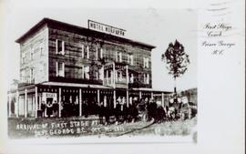
The Prince George Railway & Forestry Museum Society Collection consists primarily of textual, photographic, and cartographic records related to the regional developments of the railway industry in Northern BC. A predominant portion of the collection is made up of material from the Canadian National Railway; other railways represented include the Pacific Great Eastern Railway, the British Columbia Railway (BC Rail), the Grand Trunk Pacific Railway, the Grand Trunk Railway, the Intercolonial Railway, and the Okanagan Express. Significant geographical areas covered include Prince George, the Peace River Region, Terrace, Bulkley Valley, Hazelton and Prince Rupert.

The forestry industry is represented in the collection with operational and financial records from Fyfe Lake Sawmill Ltd., which operated southwest of Prince George in the 1950s.

The collection has been organized into series according to creator, each of which also has been arranged to subseries, file and item level, where applicable. This collection consists of eight series, as follows:

1) Canadian National Railway
2) Grand Trunk Railway
3) Pacific Great Eastern Railway
4) British Columbia Railway (BC Rail)
5) Canadian Pacific Railway (CPR)
6) Intercolonial Railway
7) Fyfe Lake Sawmill ltd.
8) PGRFM
9) Photographs

Trelle Morrow Collection
2007.47 · Collection · [2007]

Includes an audiocassette and a CD copy of an interview conducted by Kent Sedgwick with Trelle Morrow on the history of architectural design in Prince George.

Morrow, Trelle
Flooded Railway Camp
2009.5.3.96 · Item · [1936?]
Part of Taylor-Baxter Family Photograph Collection

Photograph depicts lane in front of tent buildings flooded with water, forest trees in background. Photograph taken from canoe, portion of canoe visible in foreground. It is believed that this photograph may depict the Island Cache in flood, at Prince George, BC.

Flooded Railway Camp
2009.5.3.97 · Item · [1936?]
Part of Taylor-Baxter Family Photograph Collection

Photograph depicts lane in front of tent buildings flooded with water. Tree in midground, forest trees in background. A man can be seen between first and second row of tent buildings. Photograph taken from canoe, portion of canoe visible in right foreground. It is believed that this photograph may depict the Island Cache in flood, at Prince George, BC.

Millar Addition
2012.13.1.024 · Subseries · [between 1979 and 2000]
Part of J. Kent Sedgwick fonds

File contains slides depicting the Millar Addition suburb in Prince George, B.C.

2009.6.1.592 · Item · 17 August 2004
Part of The Honourable Iona Campagnolo fonds

Photograph taken in front of the 'icebergs' at the University of Northern British Columbia in Prince George, B.C. Campagnolo stands in middle row, third from right.

Card accompanying photograph reads: “UNBC’s 10th Anniversary, 08/17/04, With the compliments of Charles J. Jago, President and Vice-Chancellor”.

2009.6.1.591 · Item · 2000
Part of The Honourable Iona Campagnolo fonds

Photograph taken in front of the 'icebergs' at the University of Northern British Columbia in Prince George, B.C.

Label affixed to verso reads: “Interim Governing Council 2000: Back Row: Tom Steadman, Hans Wagner, Charlie Lasser, Murray Sadler, Bruce Strachan, Front Row: John Chapman, Margaret Warcup (Dediluke), Anne Martin, Walter Harwood”.

Prince George Postcard
2006.20.11.1 · Item · ca. 1940
Part of Northern BC Archives Historical Photograph Collection

Postcard image depicts streetview looking west along 3rd Ave in Prince George, B.C. Storefronts and period automobiles are visible. Handwritten annotation on photographic negative, now visible along bottom of print image reads: "3rd Ave, Prince George B.C. Looking West. HND 41".

2006.20.9.28 · Item · ca. 1954
Part of Northern BC Archives Historical Photograph Collection

Postcard featuring a photograph of a photograph of the arrival of the first stage coach at the Hotel Northern in South Fort George, BC on 19 October 1911. Handwritten annotation on recto of photograph reads: “Arrival of first stage at So. Ft. George B.C. Oct. 19, 1911. 28” Printed caption on the recto of the postcard reads: “First stage coach Prince George, B.C.” Handwritten annotation in pen on verso of postcard reads: “Mrs. C. Morris, Box 925, Penticton, BC. Thurs. 6pm, Dear Mother. Arr. Safely, good trip (bad pen!) Lovely weather. Hope all are well. Bia (?) Mary & Ed”

Animal Pen?
2012.13.1.22.28 · Item · 1970
Part of J. Kent Sedgwick fonds

Image depicts what appears to be an animal pen in Island Cache. There is a goat and numerous chickens in the image, as well as a pile of miscellaneous material.

Houses
2012.13.1.22.30 · Item · 1970
Part of J. Kent Sedgwick fonds

Image depicts a few houses in Island Cache. There are two unknown individuals present.