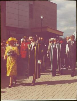
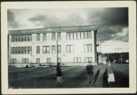
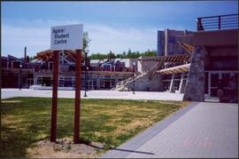
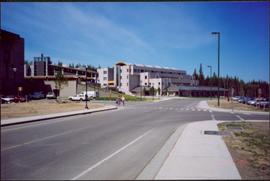
Photograph depicts road at University of Northern British Columbia. Library building stands in center background. Administration and cafeteria buildings can be seen in left background. Accompanying note from Maureen Faulkner: "Walking up to Canada's newest 'U' - ". Photo believed to have been taken on the day Bridget Moran received an Honourary Law Degree.
Photograph depicts the Agora center at the University of Northern British Columbia in Prince George, B.C. Sign in foreground reads "Agora/Student Centre". Unidentified individuals can be seen in red blankets on upper walkway in background, above the Winter Garden. Accompanying note from Maureen Faulkner: "The first nations people, in button blankets, gather". Photo believed to have been taken on the day Bridget Moran received an Honourary Law Degree.
Lofty view of Fort George, B.C., river and paddle wheeler on right. Treed hills can be seen in background. Printed annotation on verso reads: “Fort George B. C.”
Six men stand on boardwalk in front of theatre.
Street view photograph of a large brick with a vehicle parked in front. Printed annotation on recto reads: "C.N.R. Station Prince George, B.C."
Overhead view of downtown Prince George with a forested area in the background. Printed annotation on recto reads: "South Fort George- 1914."
Street view of many vehicles parked in front of the Hotel Northern. Printed annotation on recto reads: "Hotel Northern, South Fort George."
Street level photo of George Street in Prince George, Visible businesses include the "Prince George Hotel" and "Ford" dealership. Printed annotation on recto reads: "George St. Looking North Prince George, B.C. N&D."
Winter scene with buildings, street, and utility poles. Hill in background.
Handwritten annotation on verso: “South Ft. George 1912”.
Winter landscape taken from behind railroad track. Cleared land in foreground, buildings in midground, low hills in background.
Handwritten annotation on recto: “PRINCE GEORGE 3-15-14”.
Winter landscape taken from behind railroad track. Cleared land in foreground, buildings in midground, low hills in background.
Handwritten annotation on recto: “PRINCE GEORGE 3-15-14”.
Row of buildings with path and poles. Rough cleared land in foreground, men visible in far left background.
Photograph depicts street corner view of Hotel Fort George with people and utility pole in foreground.
Handwritten annotation on verso “Hotel Fort George Central Fort George 1913".
Photograph depicts large crowd gathered in front of three story building.
Printed annotation on recto of photograph: "CARIBOO STAGE AT SOUTH FT. GEORGE B.C. OCT 19 -1911".
Photograph taken at the University of Northern British Columbia in Prince George, B.C. Campagnolo and Weller wear full regalia, and RCMP officers can be seen in crowd.
Photograph taken in front of the 'icebergs' at the University of Northern British Columbia in Prince George, B.C.
Label affixed to verso reads: “Interim Governing Council 2000: Back Row: Tom Steadman, Hans Wagner, Charlie Lasser, Murray Sadler, Bruce Strachan, Front Row: John Chapman, Margaret Warcup (Dediluke), Anne Martin, Walter Harwood”.
Photograph depicts bridge over Nechako River. Sloped cutbanks on opposite shore in background. Buildings and railroad tracks can be seen on town shore in right foreground.
Photograph depicts crowd of people in foreground near log fence. More crowds can be seen in distance at base of ski jump on either sides of the run. Jump visible at top of tree-covered hill in background. It is believed that this photograph was taken near the current location of City Hall.
Photograph depicts railway crossing in front of tent buildings. Dirt road in foreground, forest trees in background. Photograph speculated to have been taken in a construction camp at Prince George.
Photograph depicts lane in front of tent buildings flooded with water, forest trees in background. Photograph taken from canoe, portion of canoe visible in foreground. It is believed that this photograph may depict the Island Cache in flood, at Prince George, BC.
Photograph depicts lane in front of tent buildings flooded with water. Tree in midground, forest trees in background. A man can be seen between first and second row of tent buildings. Photograph taken from canoe, portion of canoe visible in right foreground. It is believed that this photograph may depict the Island Cache in flood, at Prince George, BC.
Photograph depicts a young man standing between two young women in front of three-story elementary school in Prince George, B.C. Power lines, buildings, and trees on hillside in background. Handwritten annotation on recto of photograph: "Em Joyce + Barb."
Fred stands smiling on far left, Alan wears a white shirt seventh from left in first standing row. Bushes and hedges stand behind them in midground. Large school building stands in background on left, power poles on right. Handwritten annotation on recto of photograph: "DIVISION. 9. KING GEORGE V ELEMENTARY SCHOOL. PRINCE GEORGE. B.C. SEPTEMBER. 144. PHOTO BY BRIDGMAN VANCOUVER. B.C."
Overhead photograph of Prince George, BC ca. 1950 with hills in background. Annotation on recto reads: "Prince George, B.C."
Image depicts a farmhouse on Old Summit Road in Prince George, B.C.
Image depicts the Fraser River and the Grand Trunk Pacific Bridge from Cottonwood Island Park.
Image depicts Highway 97 at 15th Ave. looking north. Map coordinates 53°54'36.0"N 122°46'55.5"W
Image depicts the Canadian National Railway Yards in Prince George, B.C.
Image depicts a few houses, most likely near the airport in Prince George, B.C.
Image depicts a view of Prince George from Cranbrook Hill looking east.
Image depicts 3rd Ave at Brunswick Street in -35 degree weather. Map coordinates 53°55'03.0"N 122°44'51.7"W
Image depicts a dog and dog house in the back of a pick-up somewhere near Prince George, B.C.
Image depicts a Cariboo Ranch style house at College Heights in Prince George, B.C.
Image depicts a view of Prince George from City Hall looking northeast with the pulp mills in the background. Map coordinates 53°54'46.3"N 122°44'41.9"W
Image depicts downtown Prince George taken from City Hall looking north. Map coordinates 53°54'46.2"N 122°44'43.9"W
Image depicts downtown Prince George taken from City Hall looking northwest. Map coordinates 53°54'46.2"N 122°44'43.9"W
Image depicts a Beehive Burner along the Nechako on River Road. Map coordinates 53°55'34.1"N 122°44'58.0"W
Image depicts the Prince George Public Library (Bob Harkins Branch). Map coordinates 53°54'44.6"N 122°45'01.7"W
Image depicts a neighbourhood on North Meadows Road in Prince George, B.C.
Image depicts Parkside Intermediate Care Home on Ospika Boulevard in Prince George. Map coordinates 53°55'02.6"N 122°47'41.6"W
Image depicts the Fort George Regional Museum in Prince George, B.C. Map coordinates 53°54'18.6"N 122°44'09.8"W
Image depicts 3rd Ave at Victoria St. Map coordinates 53°55'03.9"N 122°44'54.8"W
Image depicts the Salvation Army on Ospika Boulevard in Prince George, B.C. Map coordinates 53°55'02.6"N 122°47'41.6"W
Image depicts a view of Prince George.
Image depicts the Lakeland Sawmill in Prince George, B.C, identified by the beehive burners; the one with white smoke belonged to Pas Lumber Co. which was bought out by Lakeland in 1987.
Image depicts the Lakeland Sawmill in Prince George, B.C.
Image depicts Prince George, B.C.
Image depicts a snow sculpture of a man with a shovel, possibly during the Winter City Conference, in Prince George, B.C. Taken at the Prince George Civic Center. Map coordinates 53°54'45.6"N 122°44'59.6"W
Image depicts the Northwood Bridge in Prince George, B.C.