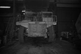
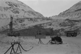
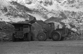
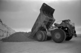
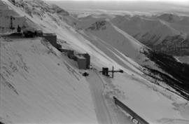
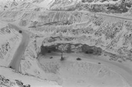
Photograph depicts the Cassiar mine on McDame Mountain. Blasthole drills and ore haulage trucks visible below in open pit and on switchback road.
Photograph depicts blasthole drill on left, bulldozer in centre, and shovel loading ore haulage truck in background. Second haul truck is semi-visible on far right. Hose equipment can be seen in foreground.
Photograph depicts a shovel loading what appears to be a Euclid ore haulage truck in excavation area of mine.
Photograph depicts a Euclid ore haulage truck dumping material on pile in left foreground.
Photograph depicts crusher buildings in left foreground, located west of mine on McDame Mountain. Southeast mountain range in background.
Photograph depicts what appears to be a Euclid ore haulage truck at entrance of building speculated to be the truck dumping station at crusher plant in mine.
Photograph depicts ore cars on cables running between tramline towers on left. Road in right foreground, building and McDame mountain in background. Tramline ran through mine valley, between loading station in mine and dump station at mill on plantsite.
Plant buildings stand in midground. Conveyor believed to be leading to tailings pile can be seen in foreground. Valley and mountains in background.
Photograph depicts pallets of fibre bags in shipping area (believed to be in mill building).
Photograph depicts unidentified man operating forklift. Pallets of asbestos fibre sit on trailer in background. Believed to have been taken in shipping area of mill building.
A black and white photographic print of Iona Campagnolo in the Cassiar mill wearing a ‘VISITOR’ hard hat and overalls. Two unidentified workers provide a tour of the mill and show sample of the asbestos fibres.
Item is a photograph of two men swede sawing a log.
Item is a photograph of from left, Ralph Robbins and Jack Paine of the BC Forest Service, Ray Williston, Chief Forester for Canadian Forest Products Tom Wright, Deputy Minister of Forests Finley McKinnon, Canadian Forest Products Vice-President in Charge of Development John Liersch, and BC Chief Forester John Stokes investigating small wood in an area near Prince George.
Item is a photograph of Ray Williston and John Liersch in a small wood area southwest of Prince George.
Photograph depicts Red Mountain Lumber Company mill owned by Roy Spurr in Penny, BC in 1929. Scattered all around the mill are the remnants of the previous coniferous forest that was destroyed in the Penny Fire that occurred 2 years earlier.
Caption describing photograph: "Bark habit at mid-bole."
Caption describing photograph: "Small area of transplants on West side of clearing, established Spring 1966. Note thrifty stand of aspend with Spruce understory, typical of stands on this soil type and history of burning."
Caption describing photograph: "Foreground cultivated in readiness for establishment of seed or transplant beds. Backgroun is transplant area est. Spring 1966."
Caption describing photograph: "Condition after hand pulling, piling and burning, and rough clearing. Note roots in soil. Northwest Cor of present clearing."
No caption provided with photograph. Similar photograph has the following caption: "View of transplant and seed bed areas, established Spring 1966. Buildings moved from Forest Service warehouse site on 15 Ave."
Caption describing photograph: "Female flowers of White Spruce. Davie Lake, prior to pollenation. June 16/1968."
Caption describing photograph: "First year female strobilus on Lodgepole Pine."
Caption describing photograph: "Top Pruning of 1 1/2 + 1 1/2 Lodgepole Pine at Red Rock Nursery. Block No. 3. Pruned to 8". Control."
Caption describing photograph: "Pulpwood Logging Operations on P.T.S. X91960, Swamp Lake, Prince George Pulp and Paper Ltd."
Item is a 3.5" floppy labelled "Aleza Lake Stem Map Data – AutoCAD Release 14 – Northline 1998". Floppy contains the following file: mofcopy.dwg.
Photograph is one of six relating to Plot 108. Multiple copies of the photographs exist.
Map of Timber Sale X9696 shows the area for the TSX with the location of plots, roads, traverse posts, and the Forest Branch cabin. Location is 4 miles from the Myra Station of the Kettle Valley Railway.
Map of Timber Sale X9696 shows topography for the area. Location is 4 miles from the Myra Station of the Kettle Valley Railway.
Photographer's photo number R880. Caption on back of photograph states: "Taken from near S.E. corner (most easterly corner) of Plot 15. Exp. Plot 160. X9696. See sketch of plot."
Photographer's photo number R882. Caption on back of photograph states: "Photo no. 1. Subplot 13. X-9696. Exp. Plot 160. See sketch of plot for location of photo."
Caption on back of photograph states: "Facing N on Sub Plot 16 showing [Reproduction] coming up"
Caption on back of photograph states: "Facing N.W. on Sub Plot 10 showing patch of small timber left after logging still intact."
Floppy contains the following files: AL94ENV.DAT, AL94VEG.DAT, ALZZ95.DOC, GISDAT.XLS.