908 results with digital objects
Show results with digital objects
2011.3.2.17
·
Item
·
1921
Part of North Coast & Central BC Postcard Collection
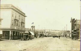
Photograph of George Street in Prince George B.C. Cars, people, and signage are visible. Printed annotation on recto reads: “George St. Prince George B.C. 1921 R7 by Moore” There is an “X” in ink over the fire hall. Handwritten annotation in ink on verso reads: “This view is also looking north and where I have put the X is the one and only fire hall and you can see the fire engine in the street. This is the main street.”
2010.13.04
·
Item
·
1922
Part of Prince George Historical Photograph Collection
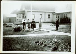
Photograph depicts two women with flowers and three men standing on grass and boardwalk in foreground, large building in background.
Handwritten annotation on verso: “Government Agency at S. Fort George 1922."

2011.3.2.12
·
Item
·
1924
Part of North Coast & Central BC Postcard Collection
River in foreground, railroad and city in mid ground and hill in background. Printed annotation on recto reads: “Prince George. B.C. 1924”

2011.3.2.32
·
Item
·
1924
Part of North Coast & Central BC Postcard Collection
Wide angle photograph of a forested area with Prince George in the distance. Printed annotation on recto reads: "Prince George, B.C. 1924."
2010.13.01
·
Item
·
1927
Part of Prince George Historical Photograph Collection
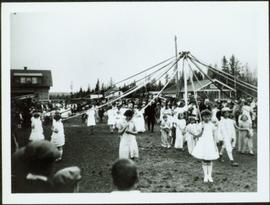
Crowd gathered around young girls holding ribbons anchored to top of pole in centre of image. Buildings stand in background.
Annotation on verso: “Maypole Dance 1927, Prince George."
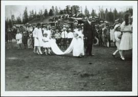
2010.13.02
·
Item
·
1927
Part of Prince George Historical Photograph Collection
Photograph depicts young girls dressed in white, walking in front of crowd. One girl holding bouquet wears a long train carried by smaller girls, and is escorted by older man wearing suit. Buildings and decorations can be seen in background.
Handwritten annotation on verso: “The May Queen, Maude Renwich attendants and Mayor Patterson".

2010.13.8
·
Item
·
1936
Part of Prince George Historical Photograph Collection
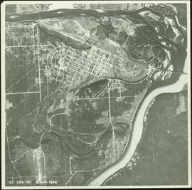
Aerial view of Prince George featuring roadways and the confluence of the Fraser and Nechako rivers.
Annotation on verso: “Prince George from air 1936”.

2020.05.42
·
Item
·
1936
Part of Gordon Wyness Album
Photograph depicts two surveyors (Jack Lee, Gordon Wyness, or Philip Monckton) taking bearings from Pineview Station tower east of Prince George. Their surveying transit and telescope are visible in the image.

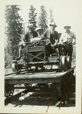
2020.05.25
·
Item
·
[Sept. or Oct. 1936]
Part of Gordon Wyness Album
Photograph depicts a view of the city of Prince George looking west from the east hill. The confluence of the Fraser River and Nechako River is visible to the right. The Grand Trunk Pacific Railway bridge is visible at centre. The current location of where this photograph may have been taken is likely somewhere near where Highway 16 rises on the hill past the correctional centre (jail).

2020.05.23
·
Item
·
[Sept. or Oct. 1936]
Part of Gordon Wyness Album
Photograph depicts (from left to right) Jack Lee, Gordon Wyness, and Lavender Monckton standing in front of a wooden moose. The wooden moose was located on top of a hill to the east of Prince George. The wooden moose was an advertisement for John A. Lestin's taxidermy business on Third Avenue in Prince George.

2020.05.28
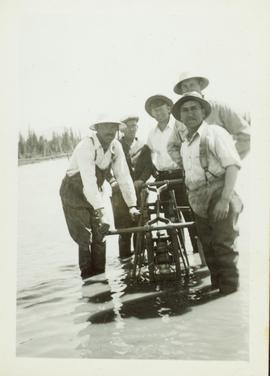
·
Item
·
[Sept. or Oct. 1936]
Part of Gordon Wyness Album
Photograph depicts (from left to right) Philip Monckton, Gordon Wyness, and Lavender Monckton at the Beaverly Geodetic Station, 7 miles west of Prince George. Surveying equipment (tripod, theodolite, and wire) are stationed at centre.

2020.05.24
·
Item
·
[Sept. or Oct. 1936]
Part of Gordon Wyness Album
Photograph depicts (from left to right) Jack Lee, Gordon Wyness, and Lavender Monckton sitting on their 1930 Buick Series 40 car in front of their temporary cabin lodgings in Prince George. This photograph was taken before the group left Prince George to head to 6 Mile Lake or Tabor Lake.
2002.1.9.2.013
·
Item
·
[ca. 1937]
Part of Prince George Railway & Forestry Museum Collection
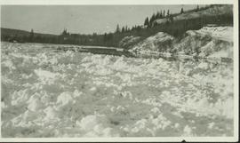
2002.1.9.2.010
·
Item
·
[ca. 1937]
Part of Prince George Railway & Forestry Museum Collection
2002.1.9.2.012
·
Item
·
[ca. 1937]
Part of Prince George Railway & Forestry Museum Collection
The road north to Salmon River is visible in the upper right corner.
2002.1.9.2.014
·
Item
·
[ca. 1937]
Part of Prince George Railway & Forestry Museum Collection
2002.1.9.2.017
·
Item
·
[ca. 1937]
Part of Prince George Railway & Forestry Museum Collection
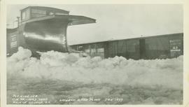
2002.1.9.2.021
·
Item
·
[ca. 1937]
Part of Prince George Railway & Forestry Museum Collection
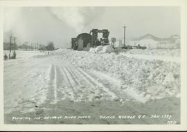
2002.1.9.2.022
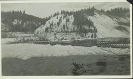
·
Item
·
[ca. 1937]
Part of Prince George Railway & Forestry Museum Collection
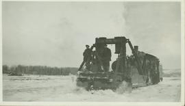
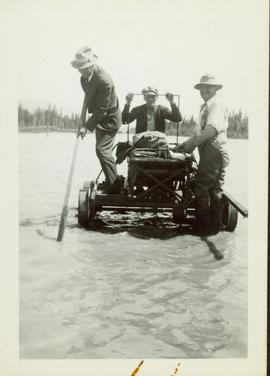
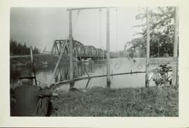
In 1936 a flood covered CN tracks in the Prince George area.
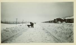
2002.1.9.2.023
·
Item
·
[ca. 1937]
Part of Prince George Railway & Forestry Museum Collection
Man in suit and hat is believed to be R.A. Harlow
2002.1.9.2.011
·
Item
·
[ca. 1937]
Part of Prince George Railway & Forestry Museum Collection
2002.1.9.2.018
·
Item
·
[ca. 1937]
Part of Prince George Railway & Forestry Museum Collection
2002.1.9.2.019
·
Item
·
[ca. 1937]
Part of Prince George Railway & Forestry Museum Collection
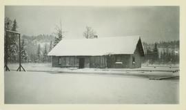
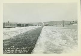
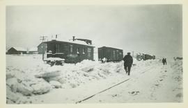
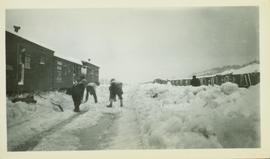
2002.1.9.2.008
·
Item
·
[ca. 1937]
Part of Prince George Railway & Forestry Museum Collection
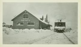
2002.1.9.2.009
·
Item
·
[ca. 1937]
Part of Prince George Railway & Forestry Museum Collection
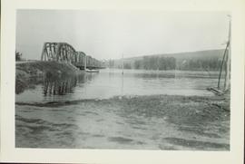
Photo taken in the late spring of 1936 at the west end of the CNR bridge when flood waters had covered up what was then known as the "tourist camp".
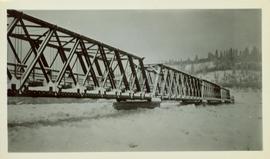
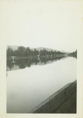
2002.1.9.2.015
·
Item
·
[ca. 1937]
Part of Prince George Railway & Forestry Museum Collection
The Nechako Bridge is also known as the Cameron Street Bridge
2002.1.9.2.016
·
Item
·
[ca. 1937]
Part of Prince George Railway & Forestry Museum Collection
2002.1.9.2.020
·
Item
·
[ca. 1937]
Part of Prince George Railway & Forestry Museum Collection
2009.5.2.326
·
Item
·
May 1938
Part of Taylor-Baxter Family Photograph Collection
Banquet was held for Visiting Officers and Delegates to the B.P.O.E. Provincial Convention in Prince George, B.C. May 25-27, 1938. The banquet was held in the Elks’ Hall on Thursday May 26, 1938. Menu features food courses, toast list and dance programme.
2010.13.14
·
Item
·
[ca. 1940 - 1950]
Part of Prince George Historical Photograph Collection
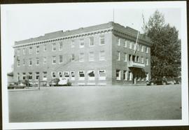
Photograph depicts large three story building, road and parked cars in foreground.
Annotation on verso: “Court House and Prov. Govt. offices at Pr. George. Once used to be 'Alexandra Hotel' now site occupied by Kresge’s. Alexander Hotel. Opened Sept 25, 1915."
2001.1.086
·
Item
·
2 Sept. 1943
Part of NBCA Document and Ephemera Collection
Pennock, W.B. RIVER CROSSING EXERCISE. Prince George, B.C. 2 SEP 43. Presented to Major-General H.N. Ganong G.O.C. 8 CDN. DIV. by Lt-Col. W.B. Pennock C.R.C.E. 8 CDN. DIV. 1943. Oblong 4to. 24pp of text, color maps, one showing the proposed crossing of Nechako River. 20 b/w snapshot photos, mounted with corners, each with captions + Appendix A, B and C of facts and figures. A large folding contemporary map of Vernon is laid in, with one of the training zones (?) highlighted on the map in a red square box. Fabricoid spine and corners.
The original typescript for a (presumably confidential and secret) document listing the preparations for defensive manoeuvres in the event of war with Japan taking place in Northern British Columbia. This document describes a simulation of what events and defences could take place, including how to conduct river crossings; when in the war game, the author imagines what would happen should the Japanese invade Prince Rupert as a starting point for the invasion of Canada.
An important document providing insight into the thinking of the Canadian military while preparing for the possibility of Japan extending its war into the North Pacific Theatre during World War II.
2009.5.4.59
·
Item
·
Aug. 1943
Part of Taylor-Baxter Family Photograph Collection
This Prize List, which was published by the Prince George Agricultural and Industrial Association incorporated with Prince George Horticultural Society, outlines the August 1943 Fall Fair rules and regulations, the prizes to be awarded; as well as a list of prize donors.
2001.1.057
·
Item
·
28 Dec. 1945
Part of NBCA Document and Ephemera Collection
Item is a program for a "welcome home banquet in honor of our soldier men and women" in Prince George on December 28, 1945. Includes a menu and a programme of events, including a welcome from Mayor Jack Nicholson.
2000.13.1.186
·
Item
·
1946.
Part of Ray Williston fonds
Item is a photograph of Prince George taken from the air.
2000.13.1.15
·
Item
·
1946
Part of Ray Williston fonds
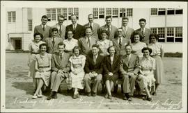
Item is a photograph of Mr. Williston with the teaching staff of the Prince George Junior Senior High School in 1946. Mr. Williston is seated front row centre.
2000.13.1.16
·
Item
·
1949
Part of Ray Williston fonds
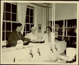
Item is a photograph of Mr. Williston washing dishes with Mrs. Evelyn Yost, Dormitory Matron, and Mrs. Houghtaling, Chief Cook, in the kitchen of the renovated army barracks which became the Prince George School’s first dormitory. The dormitory was the first of its kind in B.C.
2001.1.060
·
Item
·
[1949]
Part of NBCA Document and Ephemera Collection
This promotional map of the city of Prince George describes the city as "the hub of our northwest empire". Includes a printed map drawn by Hammond that shows significant locations in Prince George, including the Prince George Citizen office, civic arena, bus depot, civic centre, city hall, city hospital, CNR station, fire hall, government building, post office, provincial library, and the junior-senior high school. Includes numerous handwritten annotations of other locations including the women's provincial jail, old army buildings, power house, armories, bowling alley, Connaught Hill, and "The Cache".
2002.1.9.2.005
·
Item
·
1950
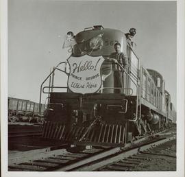
Part of Prince George Railway & Forestry Museum Collection
Man stands on the front of a PGE train next to a sign that reads: "Hello! Prince George We're Here". This photo was taken after the arrival of the first PGE train from Squamish to Prince George.

2011.12.01
·
Item
·
ca. 1950
Part of Giscome, BC Historical Photograph collection
Photo depicts a street perspective of Third Ave., in Prince George, BC, ca. 1950. Handwritten annotation in pen on verso of postcard reads: “You will undoubtedly notice that there are no tall buildings. I don’t think that there is one building in Prince George that is even five stories tall.”
2002.1.9.2.007
·
Item
·
1950
Part of Prince George Railway & Forestry Museum Collection
The CN Rail Bridge is a truss bridge over the Fraser River. It was built in 1914 by the Grand Trunk Pacific Railway and is therefore also known as the "GTP Bridge". The Canadian National (CN) Railway Company took over the Grand Trunk Pacific Railway in 1919.

2011.12.03
·
Item
·
ca. 1950
Part of Giscome, BC Historical Photograph collection
Photo depicts a street perspective cars lining Third Avenue, in Prince George, BC, ca. 1950. Annotation recto reads: "3rd Ave Prince George BC Photo J. Wrathall." Handwritten annotation in pen on verso of postcard reads: “This is the equivalent of our Granville Street. Both theatres are located here as well as Hudson Bay Co., banks, library & stores.”

2011.12.04
·
Item
·
ca. 1950
Part of Giscome, BC Historical Photograph collection
Overhead photograph of Prince George, BC ca. 1950 with hills in background. Annotation on recto reads: "Prince George, B.C."
2001.1.075
·
Item
·
[before 1975]
Part of NBCA Document and Ephemera Collection
This photocopied typescript entitled "Early Automobiles in Prince George" by Albert Bell Porter gives anecdotes and accounts relating to early automobile ownership in Prince George circa 1900-1920.
2002.1.29.2.006
·
Item
·
1950
Part of Prince George Railway & Forestry Museum Collection
The CN Rail Bridge is a truss bridge over the Fraser River. It was built in 1914 by the Grand Trunk Pacific Railway and is therefore also known as the "GTP Bridge". The Canadian National (CN) Railway Company took over the Grand Trunk Pacific Railway in 1919.
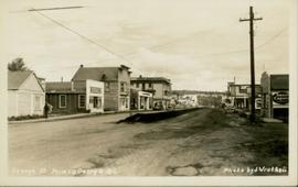
2011.12.02
·
Item
·
ca. 1950
Part of Giscome, BC Historical Photograph collection
Photo depicts a street perspective of George St., in Prince George, BC, ca. 1950. Annotation recto reads: "George St. Prince George BC Photo by J Wrathall." Handwritten annotation in pen on verso of postcard reads: “This is the Hastings Street of Prince George. This & 3rd Streets are the main thoroughfares.”
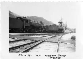
2002.1.9.3.005
·
Item
·
[ca. 1951]
Part of Prince George Railway & Forestry Museum Collection
Photograph depicts 2 steam locomotives, handwritten annotations on recto read, "59 & 161 at North Yard P.G.E. R."
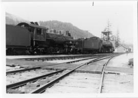
2002.1.9.3.006
·
Item
·
[ca. 1951]
Part of Prince George Railway & Forestry Museum Collection
Photograph depicts 2 steam locomotives, handwritten annotations on recto read, "59 & 161 at North Yard P.G.E. R."
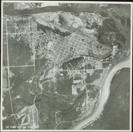
2000.13.1.187
·
Item
·
1951.
Part of Ray Williston fonds
Item is a photograph of Prince George taken from the air.
2000.8.3.18
·
Item
·
1951
Part of Ferry family fonds
Item is a photograph of the “Caribou Bench and Bar”, a group of nineteen men and one woman taken on September 7, 1951 at a dinner in honour of Peter Wilson’s 40th birthday.